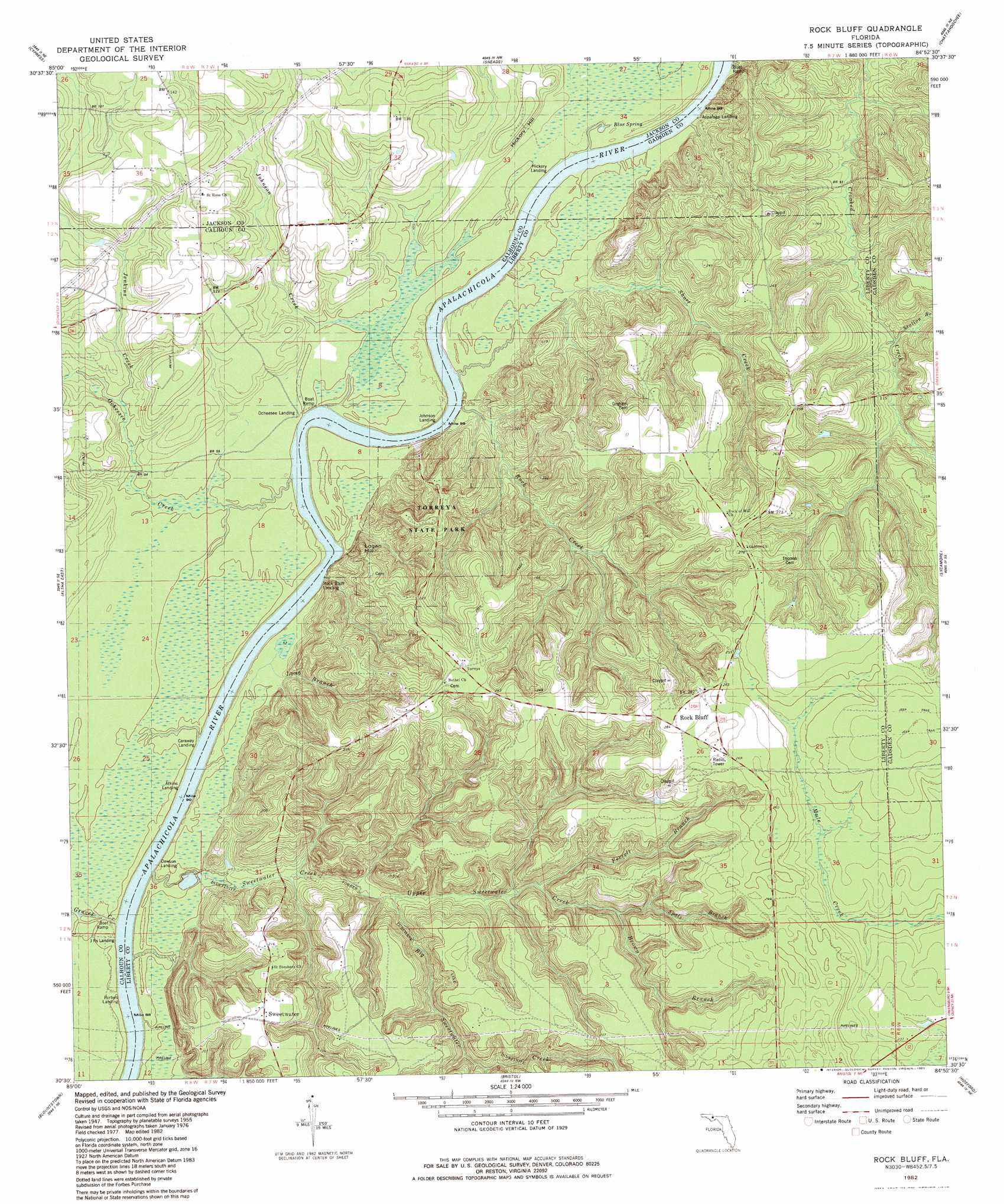
Rock Bluff Topo Map Florida
To zoom in, hover over the map of Rock Bluff
USGS Topo Quad 30084e8 - 1:24,000 scale
| Topo Map Name: | Rock Bluff |
| USGS Topo Quad ID: | 30084e8 |
| Print Size: | ca. 21 1/4" wide x 27" high |
| Southeast Coordinates: | 30.5° N latitude / 84.875° W longitude |
| Map Center Coordinates: | 30.5625° N latitude / 84.9375° W longitude |
| U.S. State: | FL |
| Filename: | O30084E8.jpg |
| Download Map JPG Image: | Rock Bluff topo map 1:24,000 scale |
| Map Type: | Topographic |
| Topo Series: | 7.5´ |
| Map Scale: | 1:24,000 |
| Source of Map Images: | United States Geological Survey (USGS) |
| Alternate Map Versions: |
Rock Bluff FL 1955, updated 1956 Download PDF Buy paper map Rock Bluff FL 1955, updated 1972 Download PDF Buy paper map Rock Bluff FL 1982, updated 1983 Download PDF Buy paper map Rock Bluff FL 2012 Download PDF Buy paper map Rock Bluff FL 2015 Download PDF Buy paper map |
1:24,000 Topo Quads surrounding Rock Bluff
Marianna |
Dellwood |
Fairchild |
Reynoldsville |
Faceville |
Oakdale |
Cypress |
Sneads |
Chattahoochee |
Mount Pleasant |
Altha West |
Altha East |
Rock Bluff |
Sycamore |
Gretna |
Clarksville |
Blountstown |
Bristol |
Hosford |
Bloxham |
Frink |
Estiffanulga |
Woods |
Telogia |
Ward |
> Back to 30084e1 at 1:100,000 scale
> Back to 30084a1 at 1:250,000 scale
> Back to U.S. Topo Maps home
Rock Bluff topo map: Gazetteer
Rock Bluff: Airports
Able Airpark elevation 41m 134′Rock Bluff: Parks
Torreya State Park elevation 81m 265′Rock Bluff: Populated Places
Hyhappo (historical) elevation 35m 114′Ocheesee Landing elevation 23m 75′
Rock Bluff elevation 92m 301′
Sweetwater elevation 60m 196′
Rock Bluff: Springs
Blue Spring elevation 29m 95′Rock Bluff: Streams
Big Sweetwater Creek elevation 35m 114′Brown Branch elevation 39m 127′
Ferrell Branch elevation 47m 154′
Graves Creek elevation 9m 29′
Jenkins Creek elevation 30m 98′
Johnson Creek elevation 24m 78′
Long Branch elevation 33m 108′
Ocheesee Creek elevation 9m 29′
Rock Creek elevation 33m 108′
Short Creek elevation 32m 104′
Spots Branch elevation 40m 131′
Station Branch elevation 39m 127′
Sweetwater Creek elevation 24m 78′
Upper Sweetwater Creek elevation 33m 108′
Rock Bluff: Summits
Hickory Hill elevation 40m 131′Rock Bluff digital topo map on disk
Buy this Rock Bluff topo map showing relief, roads, GPS coordinates and other geographical features, as a high-resolution digital map file on DVD:
Gulf Coast (LA, MS, AL, FL) & Southwestern Georgia
Buy digital topo maps: Gulf Coast (LA, MS, AL, FL) & Southwestern Georgia
 & Southwestern Georgia map DVD")