Steam Mill Topo Map Georgia
To zoom in, hover over the map of Steam Mill
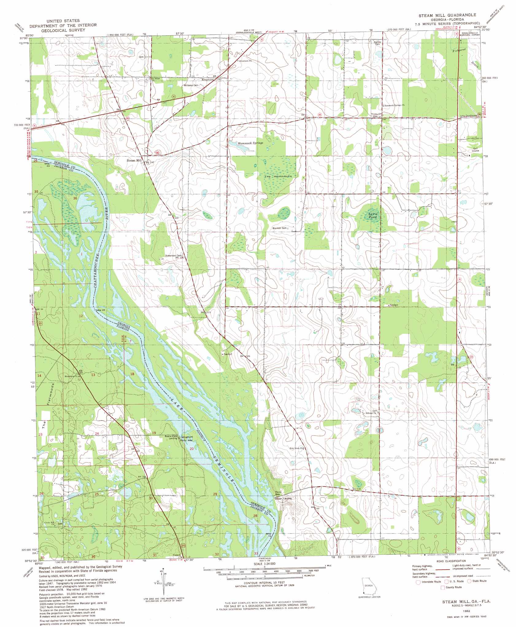
USGS Topo Quad 30084h8 - 1:24,000 scale
| Topo Map Name: | Steam Mill |
| USGS Topo Quad ID: | 30084h8 |
| Print Size: | ca. 21 1/4" wide x 27" high |
| Southeast Coordinates: | 30.875° N latitude / 84.875° W longitude |
| Map Center Coordinates: | 30.9375° N latitude / 84.9375° W longitude |
| U.S. States: | GA, FL |
| Filename: | o30084h8.jpg |
| Download Map JPG Image: | Steam Mill topo map 1:24,000 scale |
| Map Type: | Topographic |
| Topo Series: | 7.5´ |
| Map Scale: | 1:24,000 |
| Source of Map Images: | United States Geological Survey (USGS) |
| Alternate Map Versions: |
Steam Mill GA 1954, updated 1955 Download PDF Buy paper map Steam Mill GA 1954, updated 1971 Download PDF Buy paper map Steam Mill GA 1982, updated 1983 Download PDF Buy paper map Steam Mill GA 1994, updated 1998 Download PDF Buy paper map Steam Mill GA 2011 Download PDF Buy paper map Steam Mill GA 2014 Download PDF Buy paper map |
1:24,000 Topo Quads surrounding Steam Mill
Ashford |
Gordon |
Lucile |
Donalsonville Ne |
Colquitt |
Grangeburg |
Saffold |
Donalsonville West |
Donalsonville East |
Boykin |
Malone |
Bascom |
Steam Mill |
Desser |
Brinson |
Marianna |
Dellwood |
Fairchild |
Reynoldsville |
Faceville |
Oakdale |
Cypress |
Sneads |
Chattahoochee |
Mount Pleasant |
> Back to 30084e1 at 1:100,000 scale
> Back to 30084a1 at 1:250,000 scale
> Back to U.S. Topo Maps home
Steam Mill topo map: Gazetteer
Steam Mill: Lakes
Lewis Pond elevation 41m 134′Steam Mill: Populated Places
Green Acres Subdivision elevation 40m 131′Riverturn elevation 51m 167′
Steam Mill elevation 44m 144′
Steam Mill: Springs
Hammock Springs elevation 41m 134′Steam Mill: Swamps
The Hammocks elevation 45m 147′Steam Mill digital topo map on disk
Buy this Steam Mill topo map showing relief, roads, GPS coordinates and other geographical features, as a high-resolution digital map file on DVD:
Gulf Coast (LA, MS, AL, FL) & Southwestern Georgia
Buy digital topo maps: Gulf Coast (LA, MS, AL, FL) & Southwestern Georgia
 & Southwestern Georgia map DVD")