Kennedy Creek Topo Map Florida
To zoom in, hover over the map of Kennedy Creek
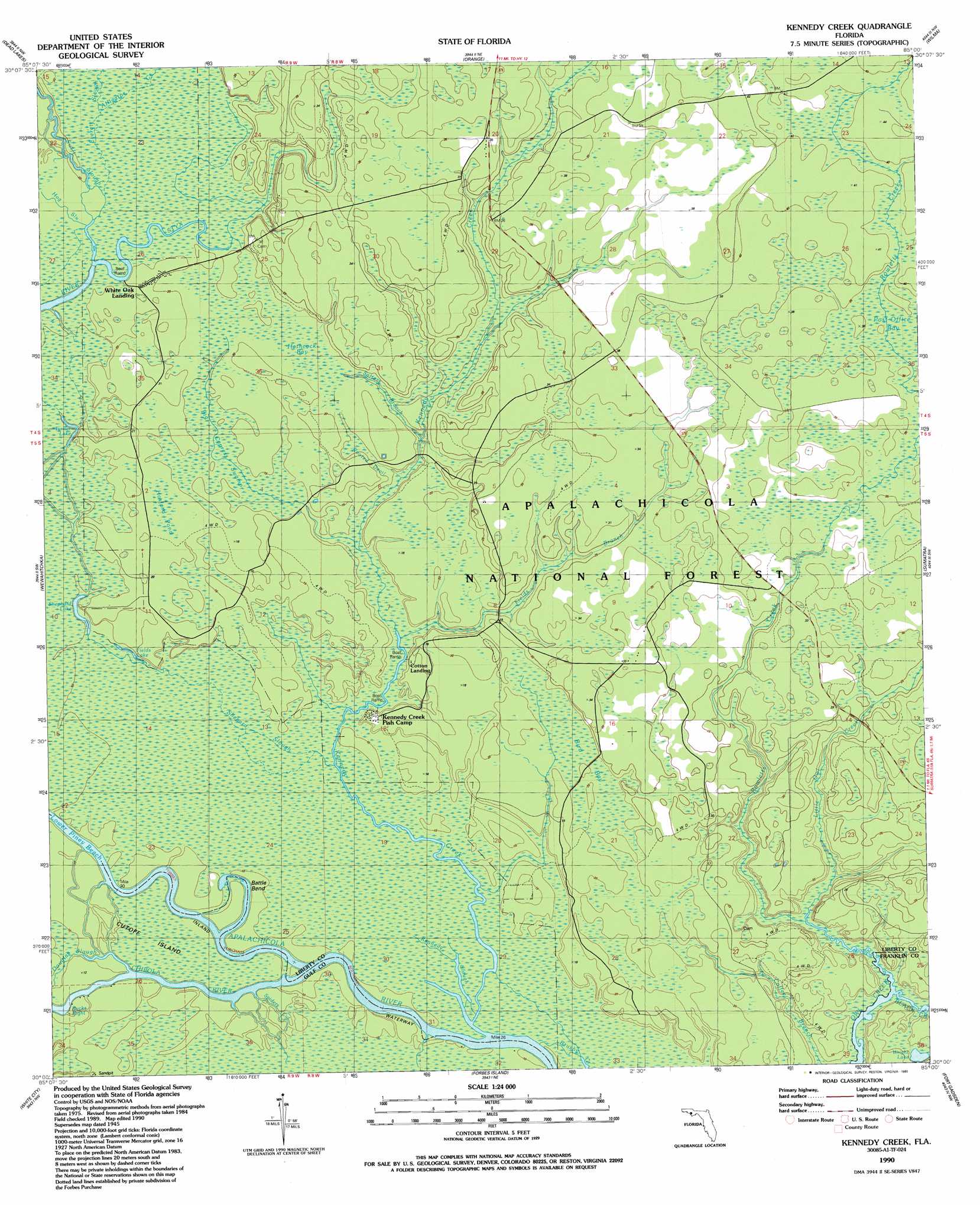
USGS Topo Quad 30085a1 - 1:24,000 scale
| Topo Map Name: | Kennedy Creek |
| USGS Topo Quad ID: | 30085a1 |
| Print Size: | ca. 21 1/4" wide x 27" high |
| Southeast Coordinates: | 30° N latitude / 85° W longitude |
| Map Center Coordinates: | 30.0625° N latitude / 85.0625° W longitude |
| U.S. State: | FL |
| Filename: | O30085A1.jpg |
| Download Map JPG Image: | Kennedy Creek topo map 1:24,000 scale |
| Map Type: | Topographic |
| Topo Series: | 7.5´ |
| Map Scale: | 1:24,000 |
| Source of Map Images: | United States Geological Survey (USGS) |
| Alternate Map Versions: |
Kennedy Creek FL 1945, updated 1960 Download PDF Buy paper map Kennedy Creek FL 1945, updated 1973 Download PDF Buy paper map Kennedy Creek FL 1990, updated 1990 Download PDF Buy paper map Kennedy Creek FL 2012 Download PDF Buy paper map Kennedy Creek FL 2015 Download PDF Buy paper map |
| FStopo: | US Forest Service topo Kennedy Creek is available: Download FStopo PDF Download FStopo TIF |
1:24,000 Topo Quads surrounding Kennedy Creek
Broad Branch |
Frink |
Estiffanulga |
Woods |
Telogia |
Tenmile Swamp |
Dead Lake |
Orange |
Wilma |
Queens Bay |
Wetappo Creek |
Wewahitchka |
Kennedy Creek |
Sumatra |
Owens Bridge |
Overstreet |
White City |
Forbes Island |
Fort Gadsden |
Tates Hell Swamp |
Port Saint Joe |
Lake Wimico |
Jackson River |
Beverly |
Green Point |
> Back to 30085a1 at 1:100,000 scale
> Back to 30084a1 at 1:250,000 scale
> Back to U.S. Topo Maps home
Kennedy Creek topo map: Gazetteer
Kennedy Creek: Bends
Battle Bend elevation 3m 9′Bucks Bight elevation 2m 6′
Kennedy Creek: Channels
Lower Piney Reach elevation 2m 6′Rooted Devil elevation 5m 16′
Kennedy Creek: Guts
Shephard Slough elevation 3m 9′Spiders Gut elevation 3m 9′
Swift Slough elevation 6m 19′
Kennedy Creek: Lakes
Fields Lake elevation 3m 9′Shephard Lake elevation 2m 6′
Solomon Lake elevation 3m 9′
Turner Lake elevation 3m 9′
Wright Lake elevation 4m 13′
Kennedy Creek: Populated Places
Escambia (historical) elevation 9m 29′Owl Landing elevation 6m 19′
White Oak Landing elevation 6m 19′
Kennedy Creek: Streams
Alligator Creek elevation 5m 16′Black Creek elevation 5m 16′
Chipola River elevation 2m 6′
Douglas Slough elevation 3m 9′
Fields Branch elevation 3m 9′
Kennedy Creek elevation 3m 9′
Kennedy Slough elevation 2m 6′
Little Owl Creek elevation 3m 9′
Rowletts Creek elevation 2m 6′
Salters Branch elevation 3m 9′
Salty Branch elevation 2m 6′
Kennedy Creek: Swamps
Big Cypress Swamp elevation 4m 13′Bird Bay elevation 6m 19′
Hathcock Bay elevation 5m 16′
Hosford Pond elevation 5m 16′
Kennedy Creek digital topo map on disk
Buy this Kennedy Creek topo map showing relief, roads, GPS coordinates and other geographical features, as a high-resolution digital map file on DVD:
Gulf Coast (LA, MS, AL, FL) & Southwestern Georgia
Buy digital topo maps: Gulf Coast (LA, MS, AL, FL) & Southwestern Georgia
 & Southwestern Georgia map DVD")