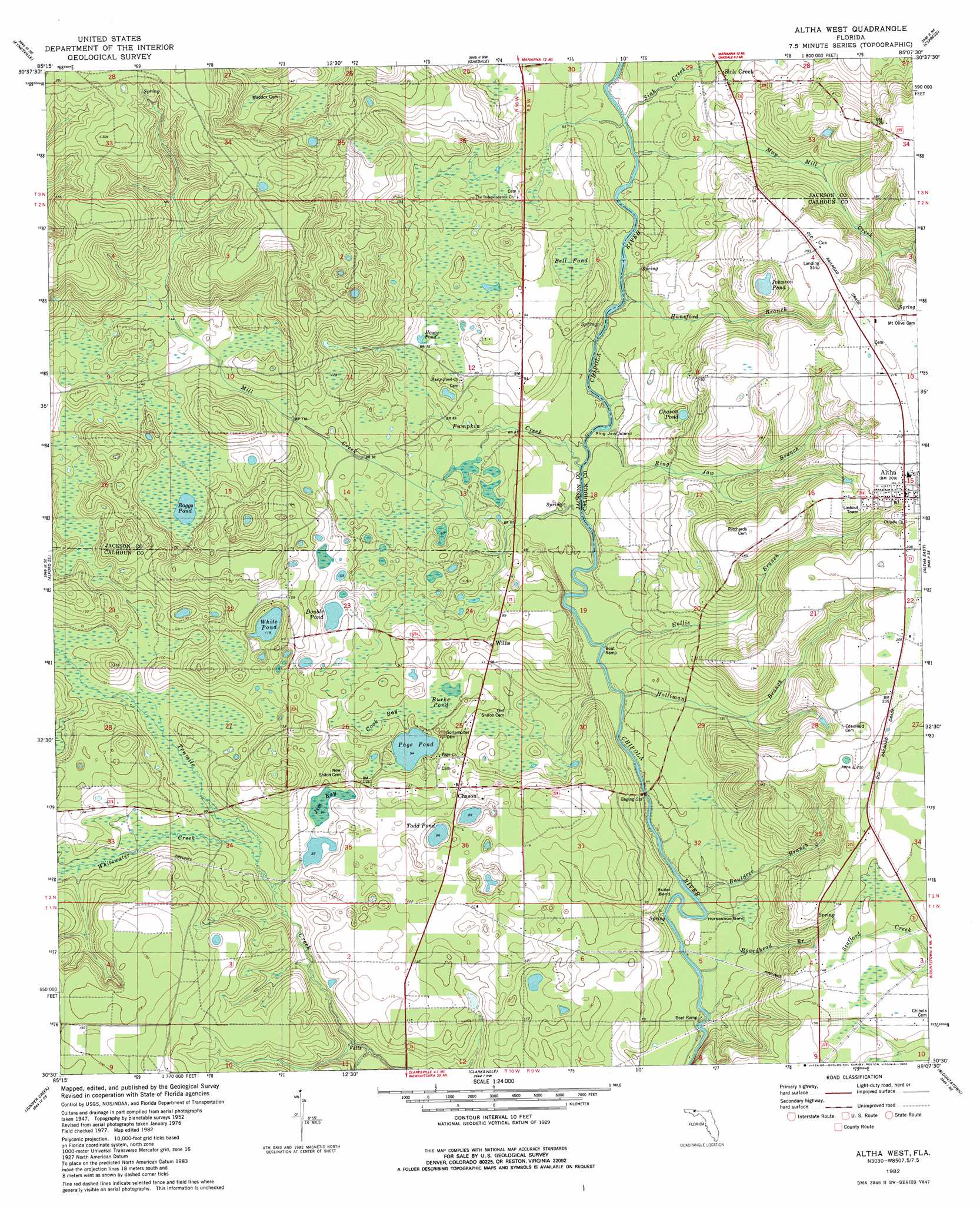
Altha West Topo Map Florida
To zoom in, hover over the map of Altha West
USGS Topo Quad 30085e2 - 1:24,000 scale
| Topo Map Name: | Altha West |
| USGS Topo Quad ID: | 30085e2 |
| Print Size: | ca. 21 1/4" wide x 27" high |
| Southeast Coordinates: | 30.5° N latitude / 85.125° W longitude |
| Map Center Coordinates: | 30.5625° N latitude / 85.1875° W longitude |
| U.S. State: | FL |
| Filename: | O30085E2.jpg |
| Download Map JPG Image: | Altha West topo map 1:24,000 scale |
| Map Type: | Topographic |
| Topo Series: | 7.5´ |
| Map Scale: | 1:24,000 |
| Source of Map Images: | United States Geological Survey (USGS) |
| Alternate Map Versions: |
Altha West FL 1952, updated 1953 Download PDF Buy paper map Altha West FL 1982, updated 1983 Download PDF Buy paper map Altha West FL 1994, updated 1998 Download PDF Buy paper map Altha West FL 2012 Download PDF Buy paper map Altha West FL 2015 Download PDF Buy paper map |
1:24,000 Topo Quads surrounding Altha West
Cottondale West |
Cottondale East |
Marianna |
Dellwood |
Fairchild |
Alford |
Kynesville |
Oakdale |
Cypress |
Sneads |
Compass Lake |
Alford Se |
Altha West |
Altha East |
Rock Bluff |
Fountain |
Juniper Creek |
Clarksville |
Blountstown |
Bristol |
Youngstown |
Broad Branch |
Frink |
Estiffanulga |
Woods |
> Back to 30085e1 at 1:100,000 scale
> Back to 30084a1 at 1:250,000 scale
> Back to U.S. Topo Maps home
Altha West topo map: Gazetteer
Altha West: Airports
Cattle Creek Ranch Airport elevation 37m 121′Farm Air Service Airport elevation 61m 200′
Altha West: Bays
Cook Bay elevation 30m 98′Gem Bay elevation 29m 95′
Altha West: Bends
Bullet Bend elevation 12m 39′Horseshoe Bend elevation 12m 39′
Altha West: Islands
Ring Jaw Island elevation 11m 36′Altha West: Lakes
Bell Pond elevation 22m 72′Boggs Pond elevation 37m 121′
Burke Pond elevation 29m 95′
Chason Pond elevation 30m 98′
Double Pond elevation 28m 91′
Johnson Pond elevation 40m 131′
Page Pond elevation 28m 91′
Todd Pond elevation 25m 82′
White Pond elevation 35m 114′
Altha West: Populated Places
Altha elevation 62m 203′Chason elevation 37m 121′
Cox elevation 61m 200′
Sink Creek elevation 23m 75′
Willis elevation 35m 114′
Altha West: Streams
Bauldree Branch elevation 11m 36′Boardhead Branch elevation 10m 32′
Hansford Branch elevation 11m 36′
Holliman Branch elevation 10m 32′
Hollis Branch elevation 10m 32′
May Mill Creek elevation 14m 45′
Mayo Mill Branch elevation 14m 45′
Mill Creek elevation 12m 39′
Pumpkin Creek elevation 12m 39′
Ring Jaw Branch elevation 11m 36′
Sink Creek elevation 15m 49′
Whitewater Creek elevation 22m 72′
Altha West: Swamps
Hasty Pond elevation 22m 72′Jim Bay elevation 28m 91′
Altha West digital topo map on disk
Buy this Altha West topo map showing relief, roads, GPS coordinates and other geographical features, as a high-resolution digital map file on DVD:
Gulf Coast (LA, MS, AL, FL) & Southwestern Georgia
Buy digital topo maps: Gulf Coast (LA, MS, AL, FL) & Southwestern Georgia
 & Southwestern Georgia map DVD")