Oakdale Topo Map Florida
To zoom in, hover over the map of Oakdale
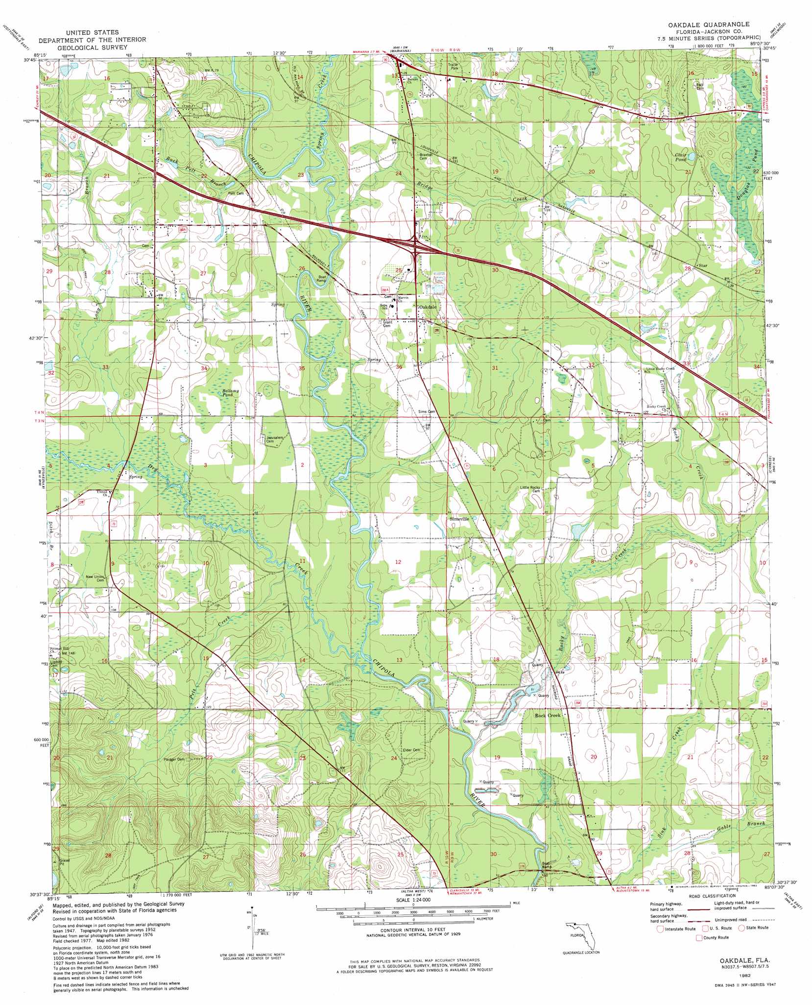
USGS Topo Quad 30085f2 - 1:24,000 scale
| Topo Map Name: | Oakdale |
| USGS Topo Quad ID: | 30085f2 |
| Print Size: | ca. 21 1/4" wide x 27" high |
| Southeast Coordinates: | 30.625° N latitude / 85.125° W longitude |
| Map Center Coordinates: | 30.6875° N latitude / 85.1875° W longitude |
| U.S. State: | FL |
| Filename: | O30085F2.jpg |
| Download Map JPG Image: | Oakdale topo map 1:24,000 scale |
| Map Type: | Topographic |
| Topo Series: | 7.5´ |
| Map Scale: | 1:24,000 |
| Source of Map Images: | United States Geological Survey (USGS) |
| Alternate Map Versions: |
Oakdale FL 1952, updated 1953 Download PDF Buy paper map Oakdale FL 1982, updated 1982 Download PDF Buy paper map Oakdale FL 1994, updated 1998 Download PDF Buy paper map Oakdale FL 2012 Download PDF Buy paper map Oakdale FL 2015 Download PDF Buy paper map |
1:24,000 Topo Quads surrounding Oakdale
Campbellton |
Sills |
Malone |
Bascom |
Steam Mill |
Cottondale West |
Cottondale East |
Marianna |
Dellwood |
Fairchild |
Alford |
Kynesville |
Oakdale |
Cypress |
Sneads |
Compass Lake |
Alford Se |
Altha West |
Altha East |
Rock Bluff |
Fountain |
Juniper Creek |
Clarksville |
Blountstown |
Bristol |
> Back to 30085e1 at 1:100,000 scale
> Back to 30084a1 at 1:250,000 scale
> Back to U.S. Topo Maps home
Oakdale topo map: Gazetteer
Oakdale: Guts
Maddox Slough elevation 33m 108′Oakdale: Lakes
Clair Pond elevation 46m 150′Oakdale: Populated Places
Oakdale elevation 27m 88′Rock Creek elevation 24m 78′
Simsville elevation 27m 88′
Star elevation 39m 127′
Oakdale: Streams
Bridge Creek elevation 17m 55′Buck Pelt Branch elevation 19m 62′
Dry Creek elevation 16m 52′
Gable Branch elevation 21m 68′
Little Rocky Creek elevation 22m 72′
Long Branch elevation 20m 65′
Pelt Creek elevation 18m 59′
Rocky Creek elevation 16m 52′
Spring Creek elevation 21m 68′
Oakdale: Swamps
Bellamy Pond elevation 24m 78′Douglas Pond elevation 37m 121′
Oakdale digital topo map on disk
Buy this Oakdale topo map showing relief, roads, GPS coordinates and other geographical features, as a high-resolution digital map file on DVD:
Gulf Coast (LA, MS, AL, FL) & Southwestern Georgia
Buy digital topo maps: Gulf Coast (LA, MS, AL, FL) & Southwestern Georgia
 & Southwestern Georgia map DVD")