Wausau Topo Map Florida
To zoom in, hover over the map of Wausau
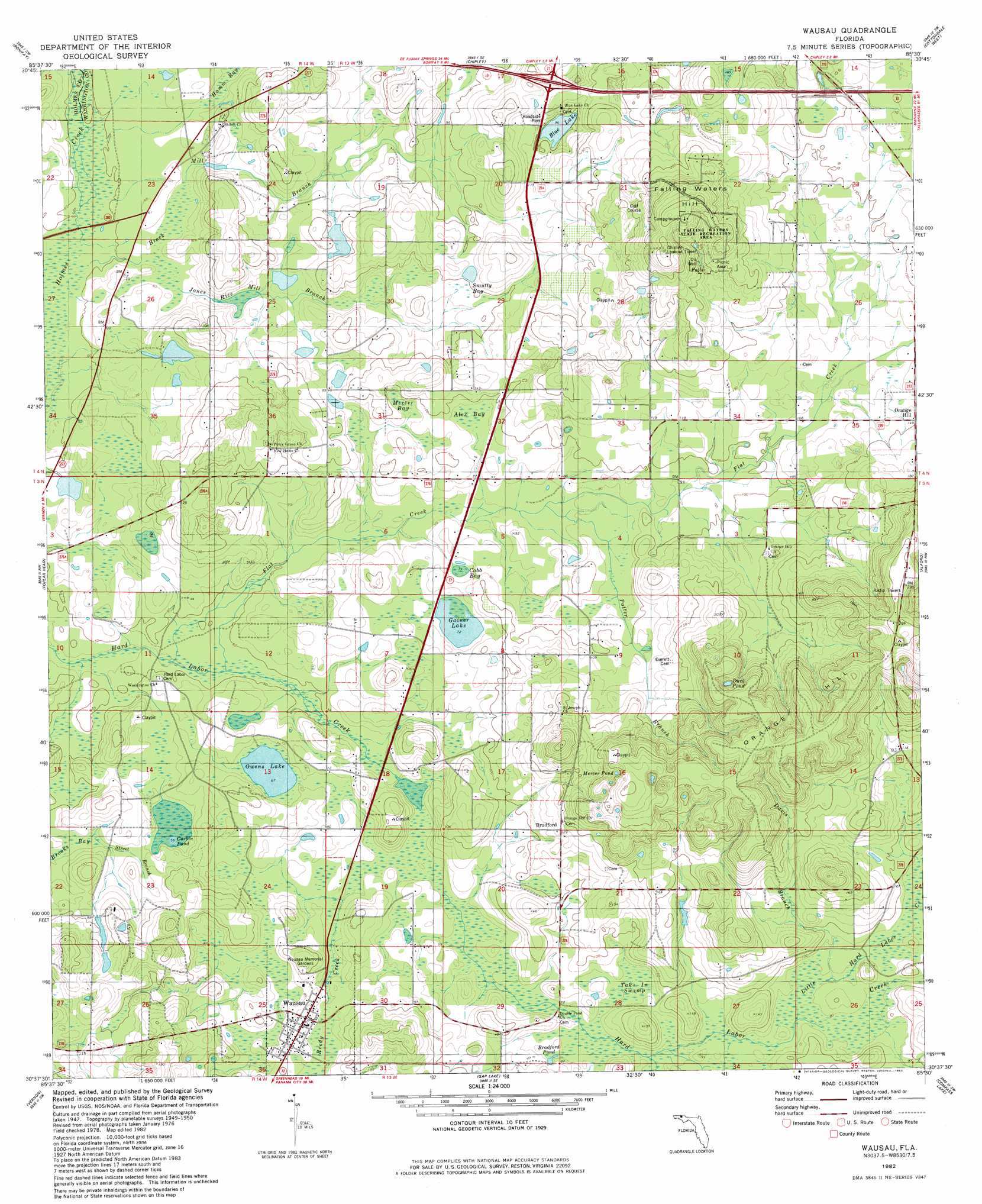
USGS Topo Quad 30085f5 - 1:24,000 scale
| Topo Map Name: | Wausau |
| USGS Topo Quad ID: | 30085f5 |
| Print Size: | ca. 21 1/4" wide x 27" high |
| Southeast Coordinates: | 30.625° N latitude / 85.5° W longitude |
| Map Center Coordinates: | 30.6875° N latitude / 85.5625° W longitude |
| U.S. State: | FL |
| Filename: | O30085F5.jpg |
| Download Map JPG Image: | Wausau topo map 1:24,000 scale |
| Map Type: | Topographic |
| Topo Series: | 7.5´ |
| Map Scale: | 1:24,000 |
| Source of Map Images: | United States Geological Survey (USGS) |
| Alternate Map Versions: |
Wausau FL 1950, updated 1968 Download PDF Buy paper map Wausau FL 1951 Download PDF Buy paper map Wausau FL 1982, updated 1983 Download PDF Buy paper map Wausau FL 1994, updated 1998 Download PDF Buy paper map Wausau FL 2012 Download PDF Buy paper map Wausau FL 2015 Download PDF Buy paper map |
1:24,000 Topo Quads surrounding Wausau
Izagora |
Esto |
Graceville |
Campbellton |
Sills |
Caryville |
Bonifay |
Chipley |
Cottondale West |
Cottondale East |
Hinsons Crossroads |
Poplar Head |
Wausau |
Alford |
Kynesville |
Millers Ferry |
Vernon |
Gap Lake |
Compass Lake |
Alford Se |
Red Head |
Crystal Lake |
Bennett |
Fountain |
Juniper Creek |
> Back to 30085e1 at 1:100,000 scale
> Back to 30084a1 at 1:250,000 scale
> Back to U.S. Topo Maps home
Wausau topo map: Gazetteer
Wausau: Airports
Orange Hill Airport elevation 72m 236′Wausau: Falls
Falling Water elevation 55m 180′Wausau: Lakes
Bells Mill Pond elevation 22m 72′Blue Lake elevation 28m 91′
Bradford Pond elevation 24m 78′
Cobb Bay Pond elevation 24m 78′
Corbin Pond elevation 16m 52′
Duck Pond elevation 59m 193′
Earnest Owen Pond elevation 20m 65′
Lake L Rancho elevation 22m 72′
Mercer Pond elevation 68m 223′
Owens Lake elevation 19m 62′
Wausau: Parks
Falling Waters State Park elevation 73m 239′Wausau: Populated Places
Bells Mill elevation 17m 55′Bradford elevation 39m 127′
Wausau elevation 29m 95′
Wausau: Streams
Brock Mill Branch elevation 14m 45′Davis Branch elevation 24m 78′
Flat Creek elevation 13m 42′
Jones Rice Mill Branch elevation 17m 55′
Little Hard Labor Creek elevation 22m 72′
Potter Branch elevation 23m 75′
Reedy Creek elevation 16m 52′
Street Branch elevation 17m 55′
Wausau: Summits
Falling Water Hill elevation 97m 318′Orange Hill elevation 87m 285′
Wausau: Swamps
Alex Bay elevation 27m 88′Brooks Bay elevation 16m 52′
Cobb Bay elevation 24m 78′
Gainer Lake elevation 22m 72′
Hamm Bay elevation 18m 59′
Harper Creek elevation 25m 82′
Mercer Bay elevation 26m 85′
Sand Hill Bay elevation 22m 72′
Smutty Bay elevation 30m 98′
Take in Swamp elevation 22m 72′
Wausau digital topo map on disk
Buy this Wausau topo map showing relief, roads, GPS coordinates and other geographical features, as a high-resolution digital map file on DVD:
Gulf Coast (LA, MS, AL, FL) & Southwestern Georgia
Buy digital topo maps: Gulf Coast (LA, MS, AL, FL) & Southwestern Georgia
 & Southwestern Georgia map DVD")