Dellwood Topo Map Florida
To zoom in, hover over the map of Dellwood
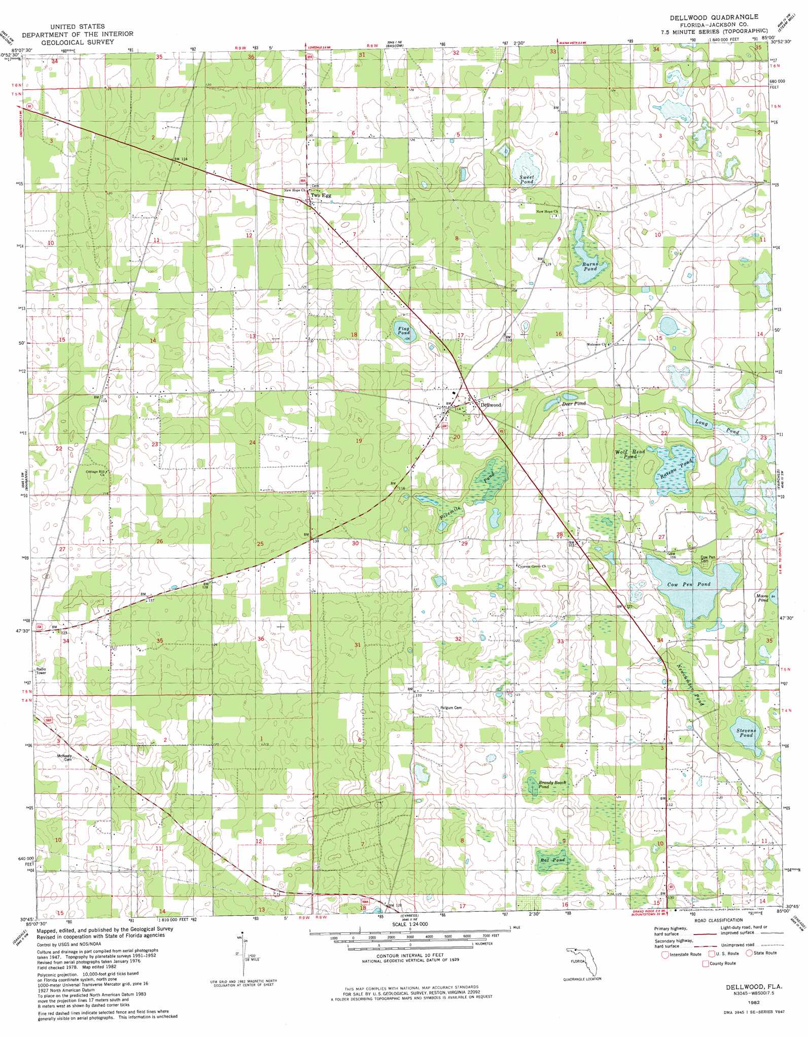
USGS Topo Quad 30085g1 - 1:24,000 scale
| Topo Map Name: | Dellwood |
| USGS Topo Quad ID: | 30085g1 |
| Print Size: | ca. 21 1/4" wide x 27" high |
| Southeast Coordinates: | 30.75° N latitude / 85° W longitude |
| Map Center Coordinates: | 30.8125° N latitude / 85.0625° W longitude |
| U.S. State: | FL |
| Filename: | O30085G1.jpg |
| Download Map JPG Image: | Dellwood topo map 1:24,000 scale |
| Map Type: | Topographic |
| Topo Series: | 7.5´ |
| Map Scale: | 1:24,000 |
| Source of Map Images: | United States Geological Survey (USGS) |
| Alternate Map Versions: |
Dellwood FL 1952, updated 1953 Download PDF Buy paper map Dellwood FL 1982, updated 1983 Download PDF Buy paper map Dellwood FL 1994, updated 1998 Download PDF Buy paper map Dellwood FL 2012 Download PDF Buy paper map Dellwood FL 2015 Download PDF Buy paper map |
1:24,000 Topo Quads surrounding Dellwood
Cottonwood |
Grangeburg |
Saffold |
Donalsonville West |
Donalsonville East |
Sills |
Malone |
Bascom |
Steam Mill |
Desser |
Cottondale East |
Marianna |
Dellwood |
Fairchild |
Reynoldsville |
Kynesville |
Oakdale |
Cypress |
Sneads |
Chattahoochee |
Alford Se |
Altha West |
Altha East |
Rock Bluff |
Sycamore |
> Back to 30085e1 at 1:100,000 scale
> Back to 30084a1 at 1:250,000 scale
> Back to U.S. Topo Maps home
Dellwood topo map: Gazetteer
Dellwood: Lakes
Burns Pond elevation 25m 82′Deer Pond elevation 26m 85′
Flag Pond elevation 31m 101′
Long Pond elevation 27m 88′
Stevens Pond elevation 25m 82′
Sweet Pond elevation 30m 98′
Dellwood: Populated Places
Dellwood elevation 32m 104′Two Egg elevation 40m 131′
Dellwood: Swamps
Bateau Pond elevation 25m 82′Brandy Beach Pond elevation 37m 121′
Cow Pen Pond elevation 25m 82′
Fivemile Pond elevation 30m 98′
Newcumber Pond elevation 27m 88′
Rat Pond elevation 38m 124′
Wolf Head Pond elevation 26m 85′
Dellwood digital topo map on disk
Buy this Dellwood topo map showing relief, roads, GPS coordinates and other geographical features, as a high-resolution digital map file on DVD:
Gulf Coast (LA, MS, AL, FL) & Southwestern Georgia
Buy digital topo maps: Gulf Coast (LA, MS, AL, FL) & Southwestern Georgia
 & Southwestern Georgia map DVD")