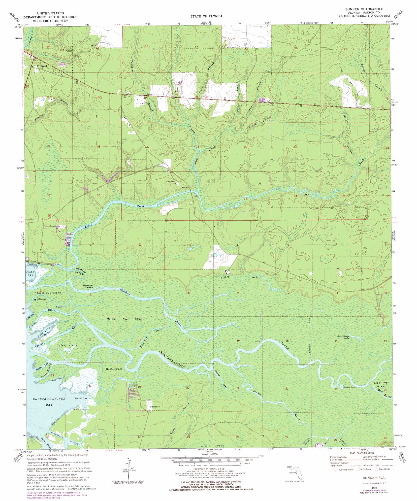
Bunker Topo Map Florida
To zoom in, hover over the map of Bunker
USGS Topo Quad 30086d1 - 1:24,000 scale
| Topo Map Name: | Bunker |
| USGS Topo Quad ID: | 30086d1 |
| Print Size: | ca. 21 1/4" wide x 27" high |
| Southeast Coordinates: | 30.375° N latitude / 86° W longitude |
| Map Center Coordinates: | 30.4375° N latitude / 86.0625° W longitude |
| U.S. State: | FL |
| Filename: | O30086D1.jpg |
| Download Map JPG Image: | Bunker topo map 1:24,000 scale |
| Map Type: | Topographic |
| Topo Series: | 7.5´ |
| Map Scale: | 1:24,000 |
| Source of Map Images: | United States Geological Survey (USGS) |
| Alternate Map Versions: |
Bunker FL 1970, updated 1972 Download PDF Buy paper map Bunker FL 1970, updated 1977 Download PDF Buy paper map Bunker FL 2012 Download PDF Buy paper map Bunker FL 2015 Download PDF Buy paper map |
1:24,000 Topo Quads surrounding Bunker
Mossy Head |
De Funiak Springs West |
De Funiak Springs East |
Ponce De Leon |
Hinsons Crossroads |
Niceville Se |
Portland |
Rock Hill |
Redbay |
Millers Ferry |
Choctaw Beach |
Freeport |
Bunker |
Bruce |
Red Head |
Miramar Beach |
Grayton Beach |
Point Washington |
Seminole Hills |
West Bay |
Laguna Beach |
Panama City Beach |
> Back to 30086a1 at 1:100,000 scale
> Back to 30086a1 at 1:250,000 scale
> Back to U.S. Topo Maps home
Bunker topo map: Gazetteer
Bunker: Bays
Bunker Cove elevation 0m 0′Duck Lake elevation 0m 0′
Bunker: Islands
Nancys Cut Island elevation 0m 0′Opossum Island elevation 1m 3′
Bunker: Lakes
Inside Lake elevation 0m 0′Muddy Lake elevation 1m 3′
Smokehouse Lake elevation 1m 3′
Bunker: Parks
Eden Gardens State Park elevation 1m 3′Bunker: Populated Places
Bunker elevation 2m 6′Old Bay View elevation 1m 3′
Bunker: Streams
Bells Leg elevation 0m 0′Black Creek elevation 1m 3′
Camp Creek elevation 0m 0′
Choctawhatchee River elevation 0m 0′
Cypress River elevation 0m 0′
East River elevation 0m 0′
Gardner Run elevation 1m 3′
Indian River elevation 0m 0′
Joyce Branch elevation 2m 6′
Live Oak Cutoff elevation 0m 0′
McIver Branch elevation 1m 3′
Mitchell River elevation 0m 0′
Pate Branch elevation 1m 3′
Reedy Branch elevation 1m 3′
Roaring Creek elevation 1m 3′
Rushing Cutoff elevation 0m 0′
Silcox Branch elevation 2m 6′
Sister River elevation 1m 3′
South Mouth elevation 0m 0′
Tenmile Branch elevation 0m 0′
Tucker Bayou elevation 0m 0′
Turnpike Branch elevation 2m 6′
Walker Branch elevation 2m 6′
Williams Lake elevation 0m 0′
Bunker: Swamps
Bishop Lake elevation 1m 3′Bunker Island elevation 1m 3′
Indian Island elevation 0m 0′
Mitchell River Island elevation 1m 3′
Bunker digital topo map on disk
Buy this Bunker topo map showing relief, roads, GPS coordinates and other geographical features, as a high-resolution digital map file on DVD:
Gulf Coast (LA, MS, AL, FL) & Southwestern Georgia
Buy digital topo maps: Gulf Coast (LA, MS, AL, FL) & Southwestern Georgia
 & Southwestern Georgia map DVD")