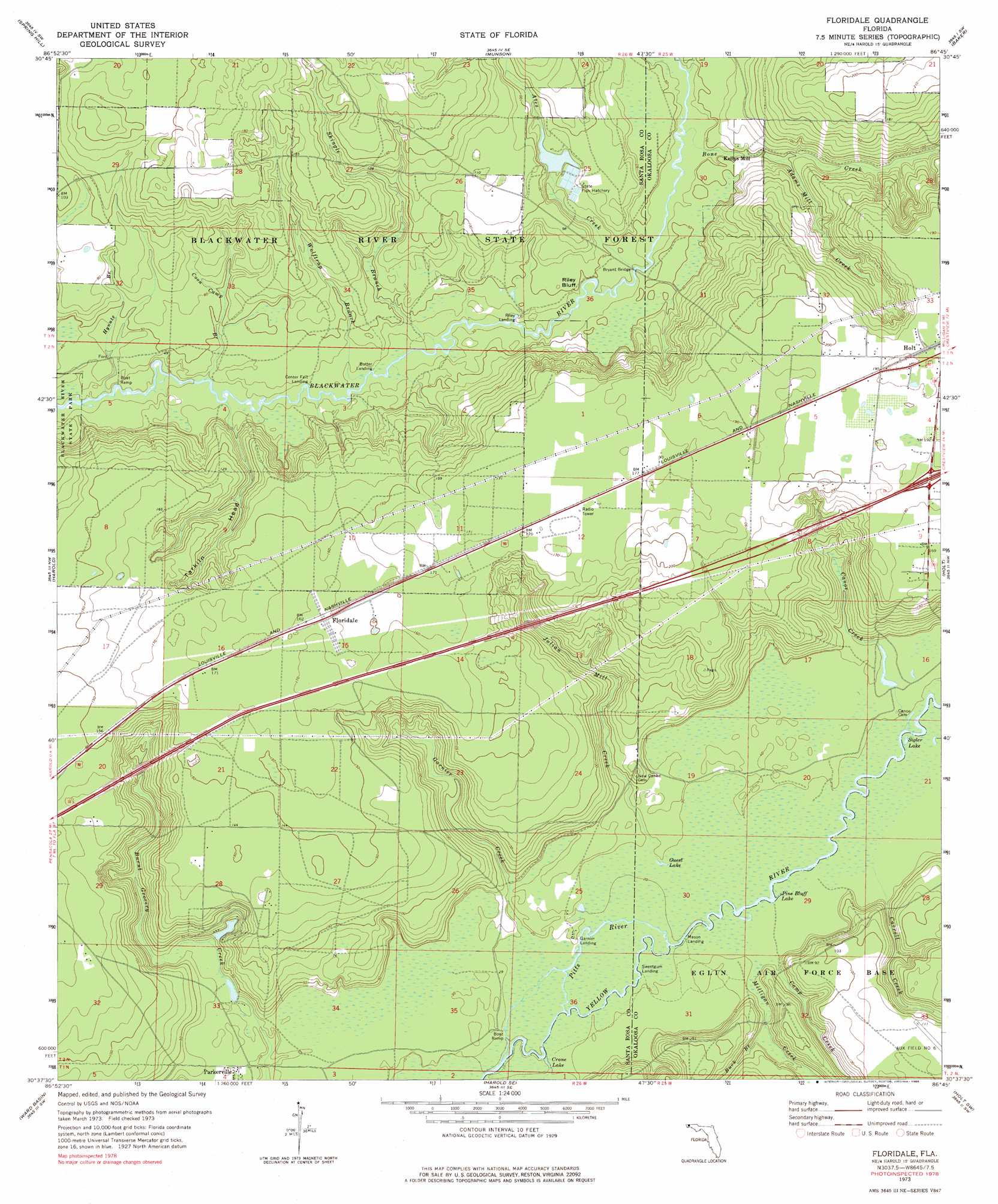
Floridale Topo Map Florida
To zoom in, hover over the map of Floridale
USGS Topo Quad 30086f7 - 1:24,000 scale
| Topo Map Name: | Floridale |
| USGS Topo Quad ID: | 30086f7 |
| Print Size: | ca. 21 1/4" wide x 27" high |
| Southeast Coordinates: | 30.625° N latitude / 86.75° W longitude |
| Map Center Coordinates: | 30.6875° N latitude / 86.8125° W longitude |
| U.S. State: | FL |
| Filename: | O30086F7.jpg |
| Download Map JPG Image: | Floridale topo map 1:24,000 scale |
| Map Type: | Topographic |
| Topo Series: | 7.5´ |
| Map Scale: | 1:24,000 |
| Source of Map Images: | United States Geological Survey (USGS) |
| Alternate Map Versions: |
Floridale FL 1973, updated 1976 Download PDF Buy paper map Floridale FL 1973, updated 1985 Download PDF Buy paper map Floridale FL 1973, updated 1985 Download PDF Buy paper map Floridale FL 2012 Download PDF Buy paper map Floridale FL 2015 Download PDF Buy paper map |
1:24,000 Topo Quads surrounding Floridale
Fidelis |
Mclellan |
Hurricane Lake |
Blackman |
Oak Grove |
Allentown |
Spring Hill |
Munson |
Baker |
Crestview North |
Milton North |
Harold |
Floridale |
Holt |
Crestview South |
Milton South |
Ward Basin |
Harold Se |
Holt Sw |
Valparaiso |
Garcon Point |
Holley |
Navarre |
Mary Esther |
Fort Walton Beach |
> Back to 30086e1 at 1:100,000 scale
> Back to 30086a1 at 1:250,000 scale
> Back to U.S. Topo Maps home
Floridale topo map: Gazetteer
Floridale: Airports
George T McCutchan Airport elevation 50m 164′Floridale: Bridges
Bryant Bridge elevation 10m 32′Floridale: Cliffs
Riley Bluff elevation 12m 39′Floridale: Lakes
Carr Lake elevation 9m 29′Crane Lake elevation 3m 9′
Guest Lake elevation 8m 26′
Pine Bluff Lake elevation 8m 26′
R B Squirls Pond elevation 15m 49′
Sigler Lake elevation 7m 22′
Floridale: Populated Places
Floridale elevation 50m 164′Kellys Mill elevation 15m 49′
Floridale: Streams
Adams Mill Creek elevation 14m 45′Ates Creek elevation 12m 39′
Bone Creek elevation 10m 32′
Buck Branch elevation 9m 29′
Camp Creek elevation 10m 32′
Canoe Creek elevation 7m 22′
Carroll Creek elevation 7m 22′
Coon Camp Branch elevation 8m 26′
Garnier Creek elevation 6m 19′
Hynote Branch elevation 6m 19′
Julian Mill Creek elevation 9m 29′
Milligan Creek elevation 9m 29′
Penny Creek elevation 11m 36′
Pitts River elevation 4m 13′
Shingle Branch elevation 8m 26′
Wolftrap Branch elevation 8m 26′
Floridale: Valleys
Tarkiln Head Hollow elevation 9m 29′Floridale digital topo map on disk
Buy this Floridale topo map showing relief, roads, GPS coordinates and other geographical features, as a high-resolution digital map file on DVD:
Gulf Coast (LA, MS, AL, FL) & Southwestern Georgia
Buy digital topo maps: Gulf Coast (LA, MS, AL, FL) & Southwestern Georgia
 & Southwestern Georgia map DVD")