Hurricane Lake Topo Map Florida
To zoom in, hover over the map of Hurricane Lake
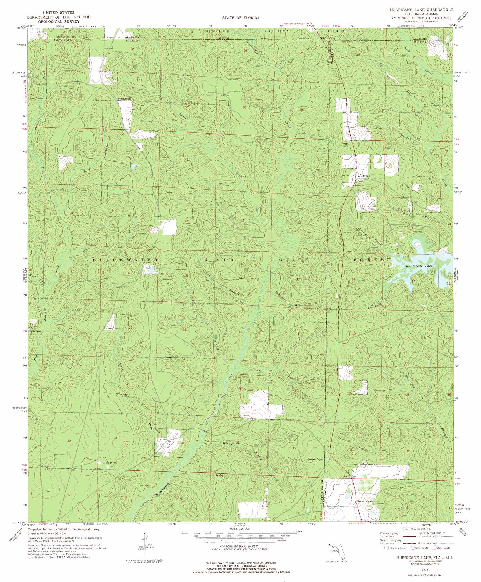
USGS Topo Quad 30086h7 - 1:24,000 scale
| Topo Map Name: | Hurricane Lake |
| USGS Topo Quad ID: | 30086h7 |
| Print Size: | ca. 21 1/4" wide x 27" high |
| Southeast Coordinates: | 30.875° N latitude / 86.75° W longitude |
| Map Center Coordinates: | 30.9375° N latitude / 86.8125° W longitude |
| U.S. States: | FL, AL |
| Filename: | O30086H7.jpg |
| Download Map JPG Image: | Hurricane Lake topo map 1:24,000 scale |
| Map Type: | Topographic |
| Topo Series: | 7.5´ |
| Map Scale: | 1:24,000 |
| Source of Map Images: | United States Geological Survey (USGS) |
| Alternate Map Versions: |
Hurricane Lake FL 1973, updated 1976 Download PDF Buy paper map Hurricane Lake FL 2011 Download PDF Buy paper map Hurricane Lake FL 2015 Download PDF Buy paper map |
| FStopo: | US Forest Service topo Hurricane Lake is available: Download FStopo PDF Download FStopo TIF |
1:24,000 Topo Quads surrounding Hurricane Lake
Brewton North |
Shipps Creek |
Damascus |
Dixie |
Carolina |
Brewton South |
Roberts |
Parker Springs |
Bradley |
Wing |
Fidelis |
Mclellan |
Hurricane Lake |
Blackman |
Oak Grove |
Allentown |
Spring Hill |
Munson |
Baker |
Crestview North |
Milton North |
Harold |
Floridale |
Holt |
Crestview South |
> Back to 30086e1 at 1:100,000 scale
> Back to 30086a1 at 1:250,000 scale
> Back to U.S. Topo Maps home
Hurricane Lake topo map: Gazetteer
Hurricane Lake: Airports
Blackwater Airfield elevation 55m 180′Hurricane Lake: Forests
Blackwater River State Forest elevation 59m 193′Hurricane Lake: Lakes
Danley Pond elevation 72m 236′Goose Pond elevation 60m 196′
Hurricane Lake: Populated Places
Beaver Creek elevation 75m 246′Belandville elevation 81m 265′
Rock Creek elevation 75m 246′
Santa Maria elevation 82m 269′
Hurricane Lake: Reservoirs
Hurricane Lake elevation 42m 137′Hurricane Lake: Streams
Barney Creek elevation 46m 150′Bear Branch elevation 33m 108′
Cedar Creek elevation 28m 91′
Cobb Branch elevation 38m 124′
Crane Branch elevation 33m 108′
Danley Branch elevation 32m 104′
Dogwood Branch elevation 34m 111′
Line Branch elevation 38m 124′
Little Escambia Creek elevation 38m 124′
Long Branch elevation 44m 144′
Mincy Branch elevation 29m 95′
Red Wash Branch elevation 41m 134′
Reedy Creek elevation 37m 121′
Verbies Branch elevation 60m 196′
Wolf Creek elevation 39m 127′
Hurricane Lake digital topo map on disk
Buy this Hurricane Lake topo map showing relief, roads, GPS coordinates and other geographical features, as a high-resolution digital map file on DVD:
Gulf Coast (LA, MS, AL, FL) & Southwestern Georgia
Buy digital topo maps: Gulf Coast (LA, MS, AL, FL) & Southwestern Georgia
 & Southwestern Georgia map DVD")