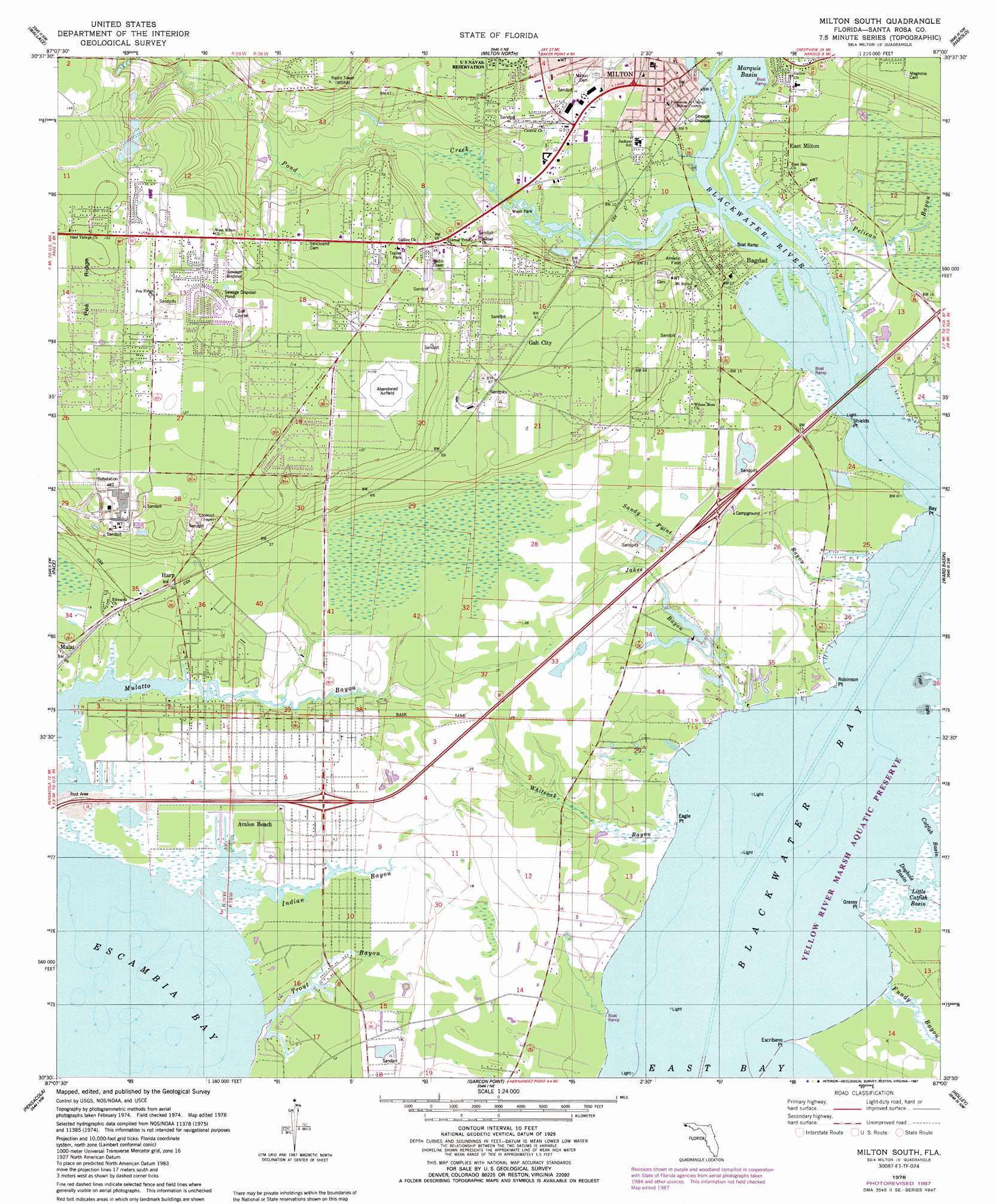
Milton South Topo Map Florida
To zoom in, hover over the map of Milton South
USGS Topo Quad 30087e1 - 1:24,000 scale
| Topo Map Name: | Milton South |
| USGS Topo Quad ID: | 30087e1 |
| Print Size: | ca. 21 1/4" wide x 27" high |
| Southeast Coordinates: | 30.5° N latitude / 87° W longitude |
| Map Center Coordinates: | 30.5625° N latitude / 87.0625° W longitude |
| U.S. State: | FL |
| Filename: | O30087E1.jpg |
| Download Map JPG Image: | Milton South topo map 1:24,000 scale |
| Map Type: | Topographic |
| Topo Series: | 7.5´ |
| Map Scale: | 1:24,000 |
| Source of Map Images: | United States Geological Survey (USGS) |
| Alternate Map Versions: |
Milton South FL 1978, updated 1978 Download PDF Buy paper map Milton South FL 1978, updated 1987 Download PDF Buy paper map Milton South FL 1994, updated 2000 Download PDF Buy paper map Milton South FL 2012 Download PDF Buy paper map Milton South FL 2015 Download PDF Buy paper map |
1:24,000 Topo Quads surrounding Milton South
Mcdavid |
Chumuckla |
Allentown |
Spring Hill |
Munson |
Molino |
Wallace |
Milton North |
Harold |
Floridale |
Cantonment |
Pace |
Milton South |
Ward Basin |
Harold Se |
West Pensacola |
Pensacola |
Garcon Point |
Holley |
Navarre |
Fort Barrancas |
Gulf Breeze |
Oriole Beach |
South Of Holley |
> Back to 30087e1 at 1:100,000 scale
> Back to 30086a1 at 1:250,000 scale
> Back to U.S. Topo Maps home
Milton South topo map: Gazetteer
Milton South: Bays
Blackwater Bay elevation 0m 0′Doghole Basin elevation 0m 0′
Little Catfish Basin elevation 0m 0′
Marquis Basin elevation 0m 0′
Milton South: Capes
Bay Point elevation 0m 0′Eagle Point elevation 0m 0′
Escribano Point elevation 0m 0′
Grassy Point elevation 0m 0′
Robinson Point elevation 0m 0′
Shields Point elevation 0m 0′
Milton South: Lakes
A J Spencer Pond elevation 32m 104′Albert Gordon Pond elevation 1m 3′
Milton South: Parks
Mayo Park elevation 2m 6′Yellow River Marsh Aquatic Preserve elevation 0m 0′
Milton South: Populated Places
Avalon Beach elevation 0m 0′Bagdad elevation 4m 13′
East Milton elevation 5m 16′
Galt City elevation 21m 68′
Harp elevation 9m 29′
Mulat elevation 3m 9′
Milton South: Ridges
Pea Ridge elevation 43m 141′Milton South: Streams
Blackwater River elevation 0m 0′Fundy Bayou elevation 0m 0′
Indian Bayou elevation 0m 0′
Jakes Bayou elevation 0m 0′
Pelican Bayou elevation 0m 0′
Pond Creek elevation 0m 0′
Sandy Point Bayou elevation 0m 0′
Trout Bayou elevation 0m 0′
Weaver River elevation 0m 0′
Whiteoak Bayou elevation 0m 0′
Milton South digital topo map on disk
Buy this Milton South topo map showing relief, roads, GPS coordinates and other geographical features, as a high-resolution digital map file on DVD:
Gulf Coast (LA, MS, AL, FL) & Southwestern Georgia
Buy digital topo maps: Gulf Coast (LA, MS, AL, FL) & Southwestern Georgia
 & Southwestern Georgia map DVD")