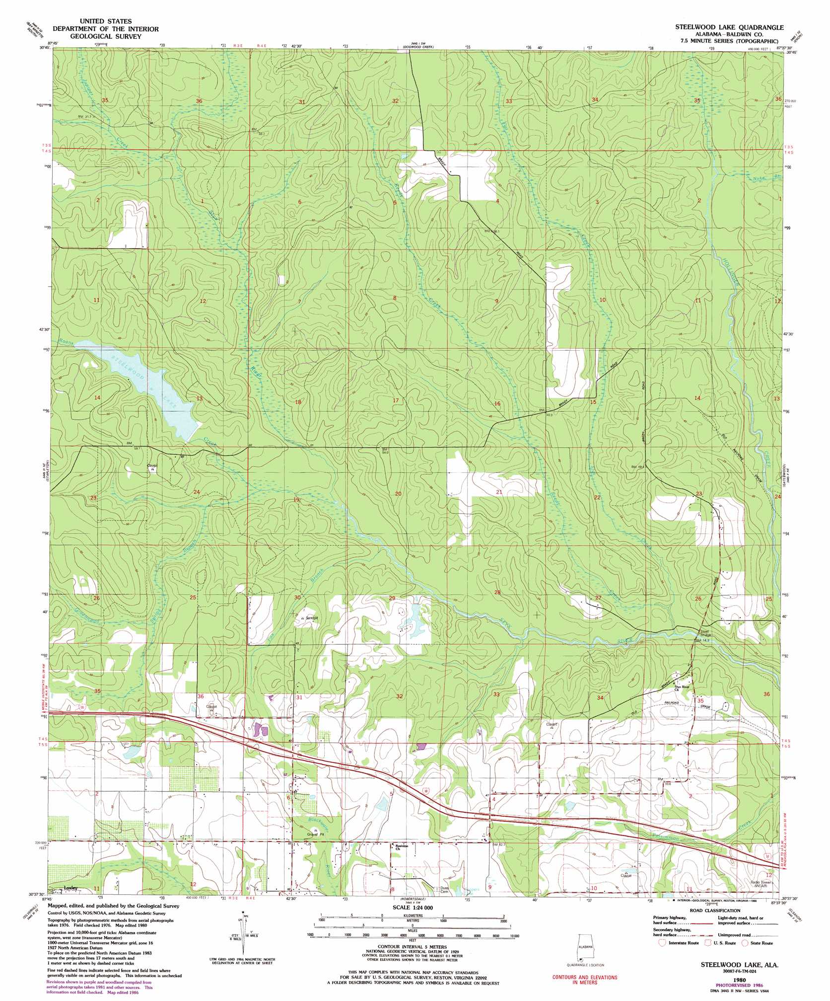
Steelwood Lake Topo Map Alabama
To zoom in, hover over the map of Steelwood Lake
USGS Topo Quad 30087f6 - 1:24,000 scale
| Topo Map Name: | Steelwood Lake |
| USGS Topo Quad ID: | 30087f6 |
| Print Size: | ca. 21 1/4" wide x 27" high |
| Southeast Coordinates: | 30.625° N latitude / 87.625° W longitude |
| Map Center Coordinates: | 30.6875° N latitude / 87.6875° W longitude |
| U.S. State: | AL |
| Filename: | o30087f6.jpg |
| Download Map JPG Image: | Steelwood Lake topo map 1:24,000 scale |
| Map Type: | Topographic |
| Topo Series: | 7.5´ |
| Map Scale: | 1:24,000 |
| Source of Map Images: | United States Geological Survey (USGS) |
| Alternate Map Versions: |
Steelwood Lake AL 1980, updated 1981 Download PDF Buy paper map Steelwood Lake AL 1980, updated 1986 Download PDF Buy paper map Steelwood Lake AL 2011 Download PDF Buy paper map Steelwood Lake AL 2014 Download PDF Buy paper map |
1:24,000 Topo Quads surrounding Steelwood Lake
The Basin |
Bay Minette North |
Dyas |
Walnut Hill |
Bratt |
Hurricane |
Bay Minette South |
Dogwood Creek |
Enon |
Bay Springs |
Bridgehead |
Stapleton |
Steelwood Lake |
Gateswood |
Barrineau Park |
Daphne |
Silverhill |
Robertsdale |
Elsanor |
Seminole |
Point Clear |
Magnolia Springs |
Foley |
Elberta |
Lillian |
> Back to 30087e1 at 1:100,000 scale
> Back to 30086a1 at 1:250,000 scale
> Back to U.S. Topo Maps home
Steelwood Lake topo map: Gazetteer
Steelwood Lake: Bridges
Old Mill Bridge elevation 27m 88′Steelwood Lake: Dams
J P Bertolli Dam elevation 50m 164′John Q Kendrick Dam elevation 34m 111′
Tennessee Coal and Iron Dam elevation 30m 98′
Steelwood Lake: Reservoirs
Bertolli Lake elevation 50m 164′Lake Kendrick elevation 34m 111′
Steelwood Lake elevation 35m 114′
Steelwood Lake: Streams
Flat Creek elevation 15m 49′Fox Branch elevation 20m 65′
Greenwood Spring Branch elevation 22m 72′
Juniper Creek elevation 24m 78′
Nuke Branch elevation 25m 82′
Reedy Creek elevation 19m 62′
Roans Creek elevation 20m 65′
Steelwood Lake digital topo map on disk
Buy this Steelwood Lake topo map showing relief, roads, GPS coordinates and other geographical features, as a high-resolution digital map file on DVD:
Gulf Coast (LA, MS, AL, FL) & Southwestern Georgia
Buy digital topo maps: Gulf Coast (LA, MS, AL, FL) & Southwestern Georgia
 & Southwestern Georgia map DVD")