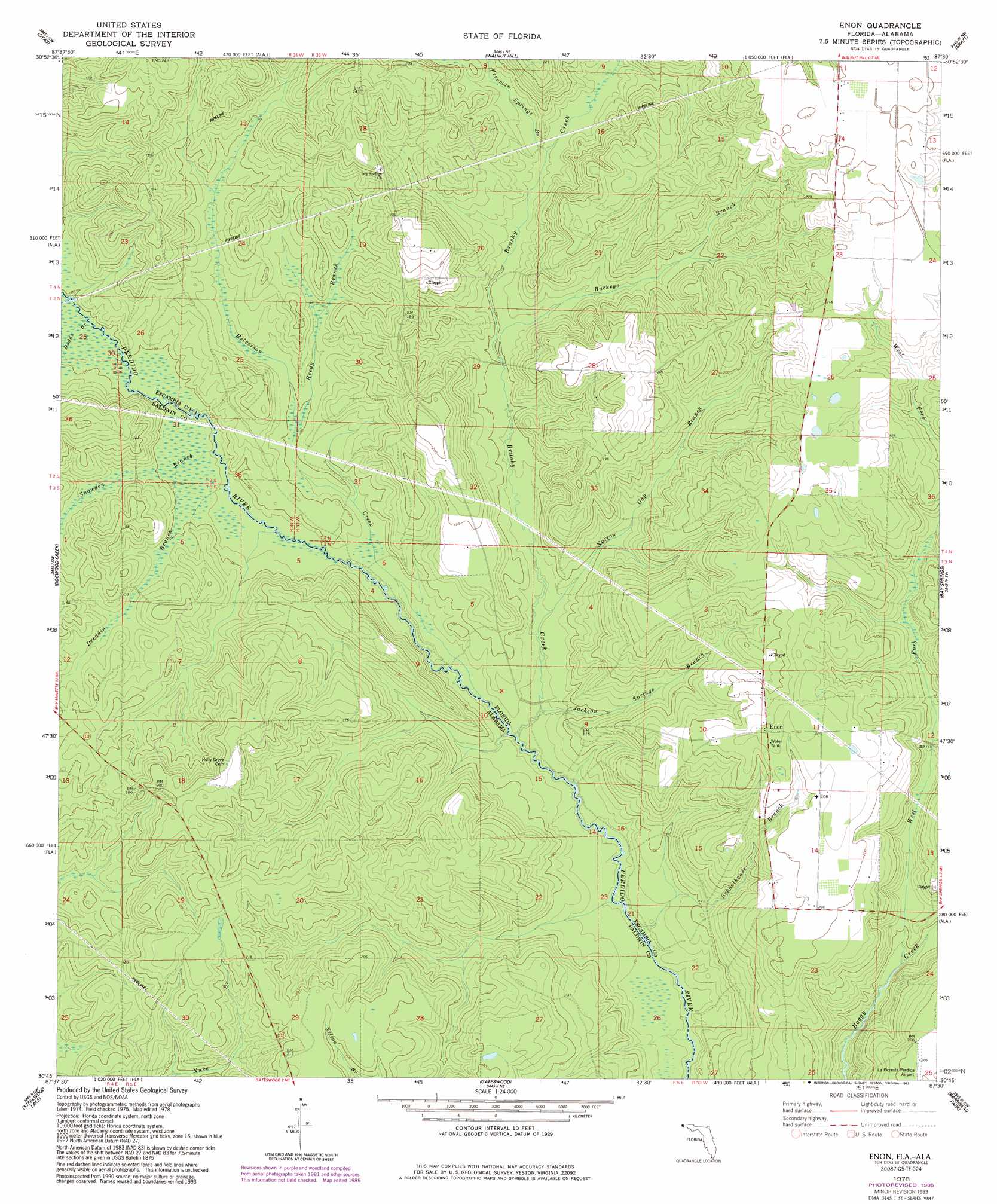
Enon Topo Map Florida
To zoom in, hover over the map of Enon
USGS Topo Quad 30087g5 - 1:24,000 scale
| Topo Map Name: | Enon |
| USGS Topo Quad ID: | 30087g5 |
| Print Size: | ca. 21 1/4" wide x 27" high |
| Southeast Coordinates: | 30.75° N latitude / 87.5° W longitude |
| Map Center Coordinates: | 30.8125° N latitude / 87.5625° W longitude |
| U.S. States: | FL, AL |
| Filename: | O30087G5.jpg |
| Download Map JPG Image: | Enon topo map 1:24,000 scale |
| Map Type: | Topographic |
| Topo Series: | 7.5´ |
| Map Scale: | 1:24,000 |
| Source of Map Images: | United States Geological Survey (USGS) |
| Alternate Map Versions: |
Enon FL 1978, updated 1978 Download PDF Buy paper map Enon FL 1978, updated 1985 Download PDF Buy paper map Enon FL 1978, updated 1985 Download PDF Buy paper map Enon FL 1978, updated 1993 Download PDF Buy paper map Enon FL 1994, updated 1998 Download PDF Buy paper map Enon FL 1994, updated 1998 Download PDF Buy paper map Enon FL 2012 Download PDF Buy paper map Enon FL 2015 Download PDF Buy paper map |
1:24,000 Topo Quads surrounding Enon
Vaughn |
Perdido |
Freemanville |
Atmore |
Flomaton |
Bay Minette North |
Dyas |
Walnut Hill |
Bratt |
Century |
Bay Minette South |
Dogwood Creek |
Enon |
Bay Springs |
Mcdavid |
Stapleton |
Steelwood Lake |
Gateswood |
Barrineau Park |
Molino |
Silverhill |
Robertsdale |
Elsanor |
Seminole |
Cantonment |
> Back to 30087e1 at 1:100,000 scale
> Back to 30086a1 at 1:250,000 scale
> Back to U.S. Topo Maps home
Enon topo map: Gazetteer
Enon: Parks
LaFlorestra Perdido Wildlife Management Area elevation 62m 203′Enon: Populated Places
Enon elevation 68m 223′Enon: Streams
Brushy Creek elevation 21m 68′Buckeye Branch elevation 29m 95′
Dodds Branch elevation 29m 95′
Dreddin Branch elevation 30m 98′
Freeman Springs Branch elevation 33m 108′
Helverson Creek elevation 22m 72′
Jackson Springs Branch elevation 21m 68′
Narrow Gap Branch elevation 23m 75′
Reedy Branch elevation 29m 95′
Schoolhouse Branch elevation 19m 62′
Snowden Branch elevation 27m 88′
West Fork Boggy Creek elevation 24m 78′
Enon digital topo map on disk
Buy this Enon topo map showing relief, roads, GPS coordinates and other geographical features, as a high-resolution digital map file on DVD:
Gulf Coast (LA, MS, AL, FL) & Southwestern Georgia
Buy digital topo maps: Gulf Coast (LA, MS, AL, FL) & Southwestern Georgia
 & Southwestern Georgia map DVD")