Little Dauphin Island Topo Map Alabama
To zoom in, hover over the map of Little Dauphin Island
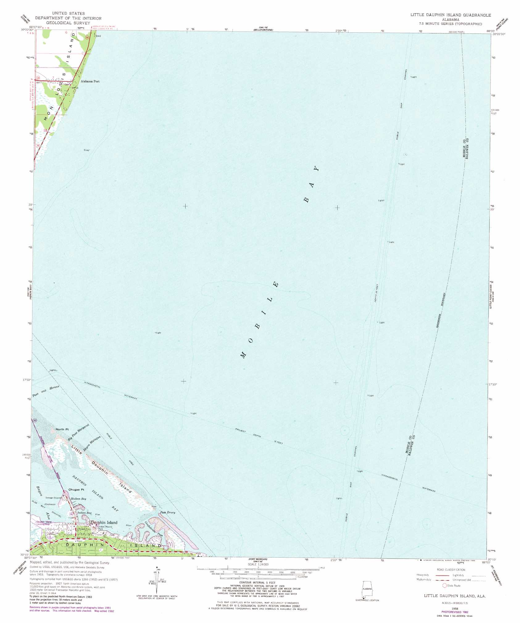
USGS Topo Quad 30088c1 - 1:24,000 scale
| Topo Map Name: | Little Dauphin Island |
| USGS Topo Quad ID: | 30088c1 |
| Print Size: | ca. 21 1/4" wide x 27" high |
| Southeast Coordinates: | 30.25° N latitude / 88° W longitude |
| Map Center Coordinates: | 30.3125° N latitude / 88.0625° W longitude |
| U.S. State: | AL |
| Filename: | o30088c1.jpg |
| Download Map JPG Image: | Little Dauphin Island topo map 1:24,000 scale |
| Map Type: | Topographic |
| Topo Series: | 7.5´ |
| Map Scale: | 1:24,000 |
| Source of Map Images: | United States Geological Survey (USGS) |
| Alternate Map Versions: |
Little Dauphin Island AL 1958 Download PDF Buy paper map Little Dauphin Island AL 1958, updated 1959 Download PDF Buy paper map Little Dauphin Island AL 1958, updated 1983 Download PDF Buy paper map Little Dauphin Island AL 2011 Download PDF Buy paper map Little Dauphin Island AL 2014 Download PDF Buy paper map |
1:24,000 Topo Quads surrounding Little Dauphin Island
Saint Elmo |
Theodore |
Hollingers Island |
Daphne |
Silverhill |
Grand Bay |
Coden |
Bellefontaine |
Point Clear |
Magnolia Springs |
Isle Aux Herbes |
Heron Bay |
Little Dauphin Island |
Little Point Clear |
Bon Secour Bay |
Petit Bois Pass |
Fort Morgan Nw |
Fort Morgan |
Saint Andrews Bay |
Pine Beach |
> Back to 30088a1 at 1:100,000 scale
> Back to 30088a1 at 1:250,000 scale
> Back to U.S. Topo Maps home
Little Dauphin Island topo map: Gazetteer
Little Dauphin Island: Bays
Barcelona Bay elevation 0m 0′Bayou Aloe elevation 0m 0′
British Bay elevation 2m 6′
Buchanan Bay elevation 0m 0′
Colony Cove elevation 0m 0′
Confederate Pass elevation 1m 3′
Coronado Cove elevation 1m 3′
Dauphin Island Bay elevation 0m 0′
Hudson Bay elevation 0m 0′
Indian Bay elevation 0m 0′
Spanish Bay elevation 0m 0′
Little Dauphin Island: Capes
Chugae Point elevation 0m 0′North Point elevation 0m 0′
Little Dauphin Island: Channels
Little Pass Margaret elevation 0m 0′Pass Chateaugue elevation 1m 3′
Pass Drury elevation 0m 0′
Spring Bayou elevation 0m 0′
Woods Bayou elevation 0m 0′
Little Dauphin Island: Islands
Cedar Island elevation 0m 0′Little Dauphin Island elevation 1m 3′
Little Dauphin Island: Parks
Cadillac Square elevation 2m 6′Indian Mound Park elevation 2m 6′
Jefferies Park elevation 2m 6′
Little Dauphin Island: Populated Places
Alabama Port elevation 2m 6′Dauphin Island elevation 2m 6′
Trade Winds Trailer Park elevation 1m 3′
Little Dauphin Island: Post Offices
Dauphin Island Post Office elevation 2m 6′Little Dauphin Island digital topo map on disk
Buy this Little Dauphin Island topo map showing relief, roads, GPS coordinates and other geographical features, as a high-resolution digital map file on DVD:
Gulf Coast (LA, MS, AL, FL) & Southwestern Georgia
Buy digital topo maps: Gulf Coast (LA, MS, AL, FL) & Southwestern Georgia
 & Southwestern Georgia map DVD")