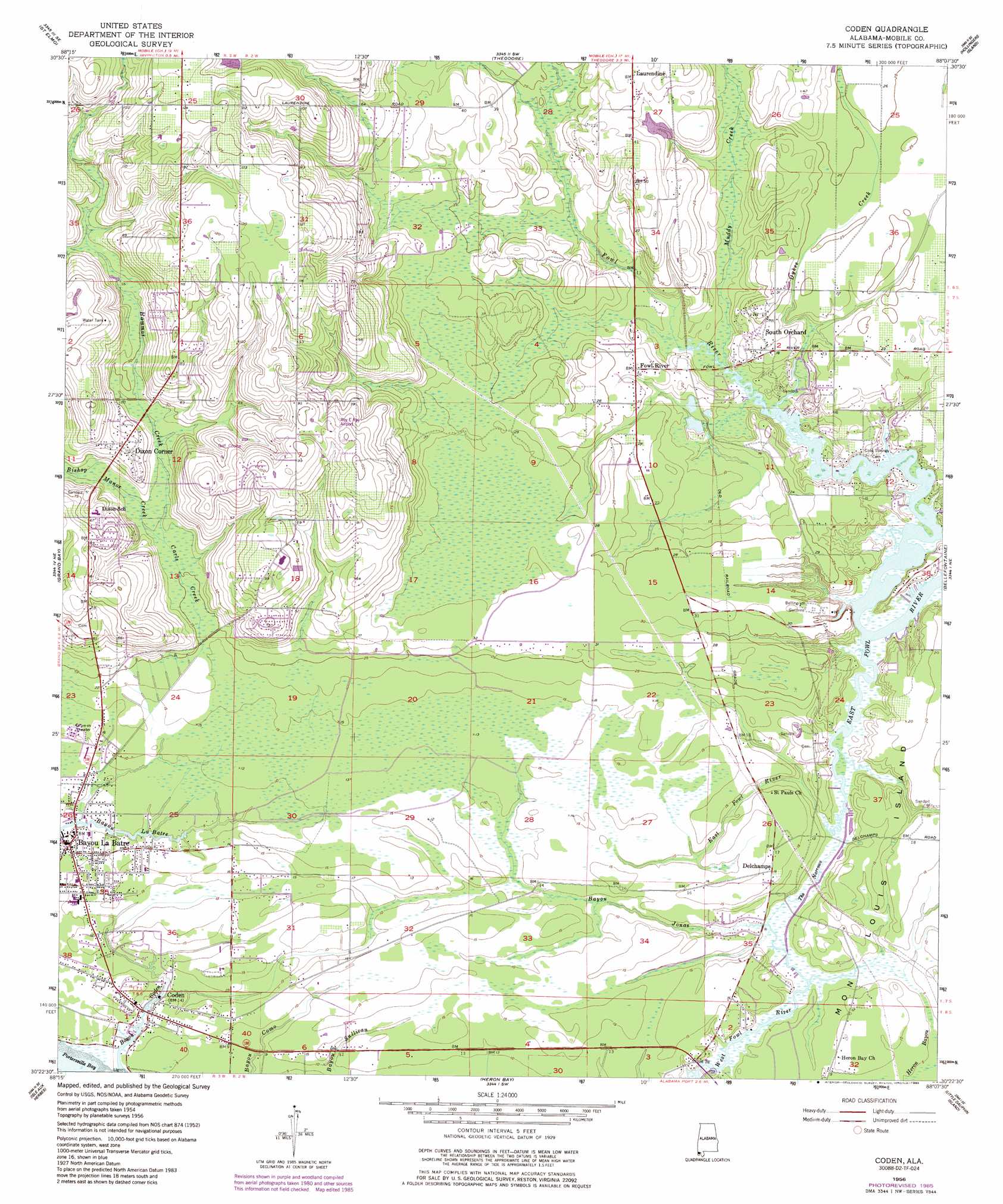
Coden Topo Map Alabama
To zoom in, hover over the map of Coden
USGS Topo Quad 30088d2 - 1:24,000 scale
| Topo Map Name: | Coden |
| USGS Topo Quad ID: | 30088d2 |
| Print Size: | ca. 21 1/4" wide x 27" high |
| Southeast Coordinates: | 30.375° N latitude / 88.125° W longitude |
| Map Center Coordinates: | 30.4375° N latitude / 88.1875° W longitude |
| U.S. State: | AL |
| Filename: | o30088d2.jpg |
| Download Map JPG Image: | Coden topo map 1:24,000 scale |
| Map Type: | Topographic |
| Topo Series: | 7.5´ |
| Map Scale: | 1:24,000 |
| Source of Map Images: | United States Geological Survey (USGS) |
| Alternate Map Versions: |
Coden AL 1956, updated 1957 Download PDF Buy paper map Coden AL 1956, updated 1975 Download PDF Buy paper map Coden AL 1956, updated 1985 Download PDF Buy paper map Coden AL 2011 Download PDF Buy paper map Coden AL 2014 Download PDF Buy paper map |
1:24,000 Topo Quads surrounding Coden
Hurley |
Tanner Williams |
Spring Hill |
Mobile |
Bridgehead |
Big Point |
Saint Elmo |
Theodore |
Hollingers Island |
Daphne |
Kreole |
Grand Bay |
Coden |
Bellefontaine |
Point Clear |
Grand Bay Sw |
Isle Aux Herbes |
Heron Bay |
Little Dauphin Island |
Little Point Clear |
Petit Bois Island |
Petit Bois Pass |
Fort Morgan Nw |
Fort Morgan |
Saint Andrews Bay |
> Back to 30088a1 at 1:100,000 scale
> Back to 30088a1 at 1:250,000 scale
> Back to U.S. Topo Maps home
Coden topo map: Gazetteer
Coden: Airports
Roy E Ray Airport elevation 29m 95′Coden: Channels
The Narrows elevation 2m 6′Coden: Dams
Bahlman Lake Dam elevation 8m 26′J E Robinson Dam elevation 38m 124′
Coden: Oilfields
Bayou Jonas Gas Field elevation 5m 16′Bellingrath Gardens Gas Field elevation 5m 16′
East Bayou Jonas Gas Field elevation 5m 16′
Mon Louis Island Gas Field elevation 4m 13′
North Bayou Jonas Gas Field elevation 3m 9′
North Delchamps Gas Field elevation 5m 16′
North Heron Bayou Gas Field elevation 4m 13′
North Mon Louis Island Gas Field elevation 5m 16′
Saint Pauls Church Gas Field elevation 5m 16′
Coden: Parks
Bellingrath Gardens elevation 8m 26′Coden: Populated Places
Bayou La Batre elevation 2m 6′Coden elevation 2m 6′
Delchamps elevation 5m 16′
Dixon Corner elevation 20m 65′
Fowl River elevation 7m 22′
Kirewakra elevation 10m 32′
Laurendine elevation 13m 42′
Nelson elevation 4m 13′
South Orchard elevation 6m 19′
Coden: Reservoirs
Bahlman Lake elevation 8m 26′J E Robinson Lake elevation 38m 124′
Coden: Streams
Bayou Coden elevation 0m 0′Bayou Jonas elevation 1m 3′
Bishop Manor Creek elevation 8m 26′
Carls Creek elevation 0m 0′
Dykes Creek elevation 0m 0′
Fowl River elevation 0m 0′
Hammar Creek elevation 8m 26′
Muddy Creek elevation 0m 0′
Coden digital topo map on disk
Buy this Coden topo map showing relief, roads, GPS coordinates and other geographical features, as a high-resolution digital map file on DVD:
Gulf Coast (LA, MS, AL, FL) & Southwestern Georgia
Buy digital topo maps: Gulf Coast (LA, MS, AL, FL) & Southwestern Georgia
 & Southwestern Georgia map DVD")