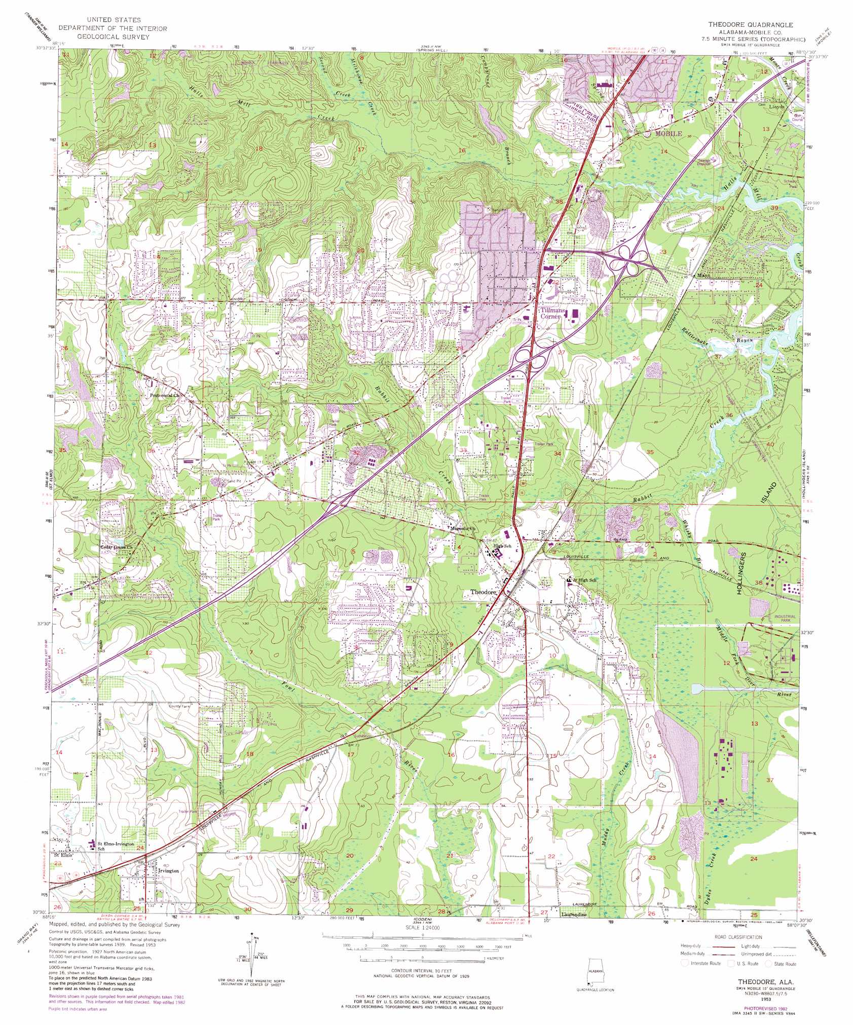
Theodore Topo Map Alabama
To zoom in, hover over the map of Theodore
USGS Topo Quad 30088e2 - 1:24,000 scale
| Topo Map Name: | Theodore |
| USGS Topo Quad ID: | 30088e2 |
| Print Size: | ca. 21 1/4" wide x 27" high |
| Southeast Coordinates: | 30.5° N latitude / 88.125° W longitude |
| Map Center Coordinates: | 30.5625° N latitude / 88.1875° W longitude |
| U.S. State: | AL |
| Filename: | o30088e2.jpg |
| Download Map JPG Image: | Theodore topo map 1:24,000 scale |
| Map Type: | Topographic |
| Topo Series: | 7.5´ |
| Map Scale: | 1:24,000 |
| Source of Map Images: | United States Geological Survey (USGS) |
| Alternate Map Versions: |
Theodore AL 1953, updated 1955 Download PDF Buy paper map Theodore AL 1953, updated 1964 Download PDF Buy paper map Theodore AL 1953, updated 1968 Download PDF Buy paper map Theodore AL 1953, updated 1975 Download PDF Buy paper map Theodore AL 1953, updated 1983 Download PDF Buy paper map Theodore AL 1953, updated 1984 Download PDF Buy paper map Theodore AL 2011 Download PDF Buy paper map Theodore AL 2014 Download PDF Buy paper map |
1:24,000 Topo Quads surrounding Theodore
Howell |
Semmes |
Kushla |
Chickasaw |
Hurricane |
Hurley |
Tanner Williams |
Spring Hill |
Mobile |
Bridgehead |
Big Point |
Saint Elmo |
Theodore |
Hollingers Island |
Daphne |
Kreole |
Grand Bay |
Coden |
Bellefontaine |
Point Clear |
Grand Bay Sw |
Isle Aux Herbes |
Heron Bay |
Little Dauphin Island |
Little Point Clear |
> Back to 30088e1 at 1:100,000 scale
> Back to 30088a1 at 1:250,000 scale
> Back to U.S. Topo Maps home
Theodore topo map: Gazetteer
Theodore: Crossings
Interchange 13 elevation 43m 141′Interchange 15 elevation 19m 62′
Interchange 17 elevation 8m 26′
Theodore: Dams
Cole Lake Dam elevation 39m 127′Riley Smith Number Two Dam elevation 34m 111′
School Board Lake Dam elevation 11m 36′
Smith Pond Dam elevation 31m 101′
Theodore: Parks
Boykin Park elevation 31m 101′Schwarz Park elevation 1m 3′
Theodore: Populated Places
Canterbury Heights elevation 19m 62′Crestview elevation 18m 59′
Irvington elevation 40m 131′
Lansdowne elevation 22m 72′
Lloyds elevation 3m 9′
Mann elevation 6m 19′
Meadow Lake elevation 46m 150′
Quail Run elevation 34m 111′
Rabbit Creek Estates elevation 37m 121′
Robinwood elevation 47m 154′
Suburban Heights elevation 36m 118′
Theodore elevation 18m 59′
Tillmans Corner elevation 25m 82′
Todd Acres elevation 4m 13′
Windcrest elevation 26m 85′
Theodore: Reservoirs
Cole Lake elevation 39m 127′Smith Pond elevation 31m 101′
Theodore: Streams
Campground Branch elevation 5m 16′Milkhouse Creek elevation 8m 26′
Rattlesnake Bayou elevation 2m 6′
Second Creek elevation 8m 26′
Spring Creek elevation 3m 9′
Whisky Branch elevation 2m 6′
Theodore digital topo map on disk
Buy this Theodore topo map showing relief, roads, GPS coordinates and other geographical features, as a high-resolution digital map file on DVD:
Gulf Coast (LA, MS, AL, FL) & Southwestern Georgia
Buy digital topo maps: Gulf Coast (LA, MS, AL, FL) & Southwestern Georgia
 & Southwestern Georgia map DVD")