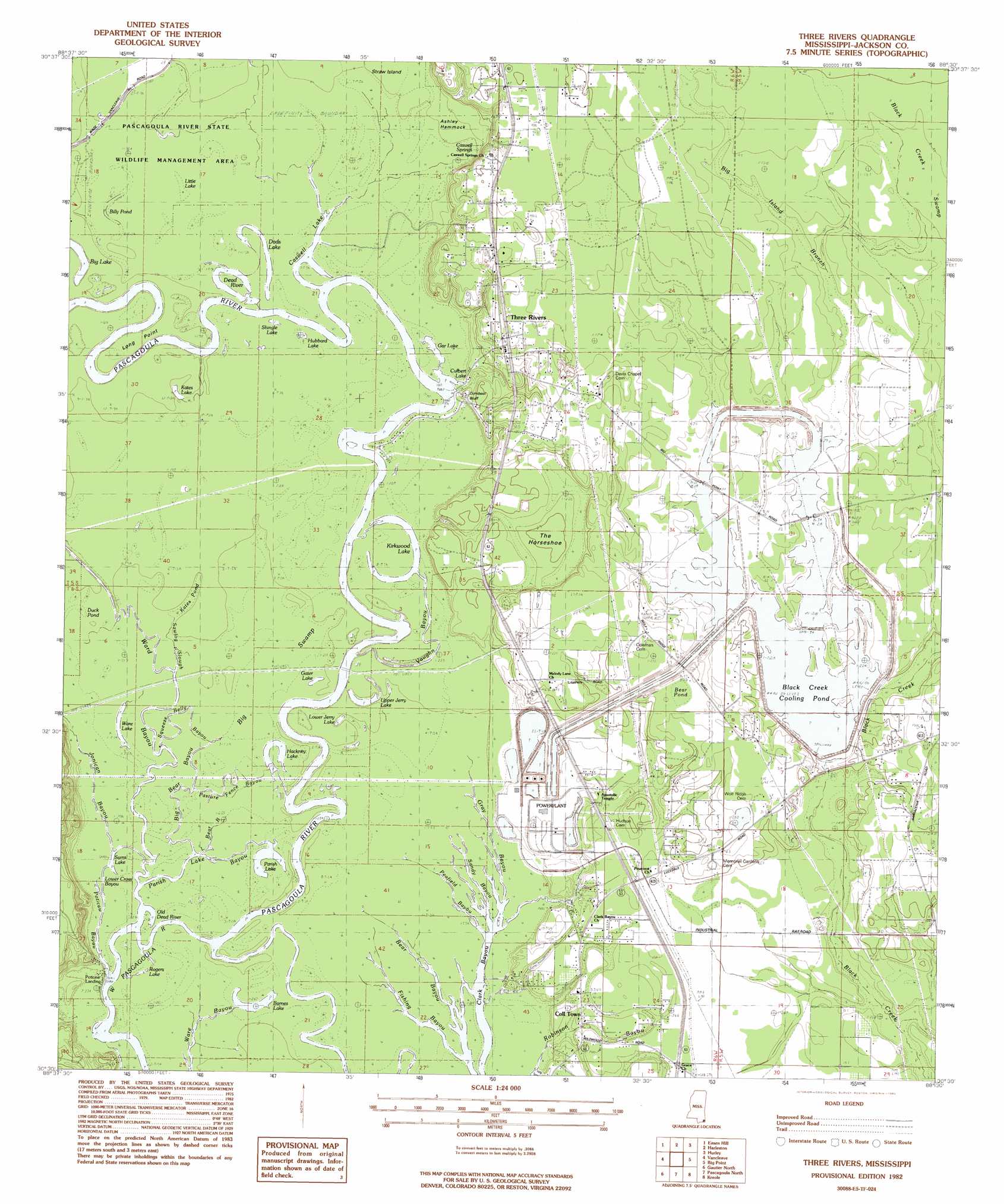
Three Rivers Topo Map Mississippi
To zoom in, hover over the map of Three Rivers
USGS Topo Quad 30088e5 - 1:24,000 scale
| Topo Map Name: | Three Rivers |
| USGS Topo Quad ID: | 30088e5 |
| Print Size: | ca. 21 1/4" wide x 27" high |
| Southeast Coordinates: | 30.5° N latitude / 88.5° W longitude |
| Map Center Coordinates: | 30.5625° N latitude / 88.5625° W longitude |
| U.S. State: | MS |
| Filename: | o30088e5.jpg |
| Download Map JPG Image: | Three Rivers topo map 1:24,000 scale |
| Map Type: | Topographic |
| Topo Series: | 7.5´ |
| Map Scale: | 1:24,000 |
| Source of Map Images: | United States Geological Survey (USGS) |
| Alternate Map Versions: |
Three Rivers MS 1982, updated 1982 Download PDF Buy paper map Three Rivers MS 1982, updated 1982 Download PDF Buy paper map Three Rivers MS 2012 Download PDF Buy paper map Three Rivers MS 2015 Download PDF Buy paper map |
1:24,000 Topo Quads surrounding Three Rivers
Benndale |
Basin |
Agricola |
Howell |
Semmes |
Vestry |
Easen Hill |
Harleston |
Hurley |
Tanner Williams |
Latimer |
Vancleave |
Three Rivers |
Big Point |
Saint Elmo |
Ocean Springs |
Gautier North |
Pascagoula North |
Kreole |
Grand Bay |
Deer Island |
Gautier South |
Pascagoula South |
Grand Bay Sw |
Isle Aux Herbes |
> Back to 30088e1 at 1:100,000 scale
> Back to 30088a1 at 1:250,000 scale
> Back to U.S. Topo Maps home
Three Rivers topo map: Gazetteer
Three Rivers: Bends
The Horseshoe elevation 6m 19′Three Rivers: Capes
Long Point elevation 5m 16′Three Rivers: Cliffs
Cumbest Bluff elevation 6m 19′Three Rivers: Dams
Black Creek Cooling Water Facility Dam elevation 7m 22′Marshall Smith Lake Dam elevation 2m 6′
Three Rivers: Guts
Big Bear Bayou elevation 3m 9′Parish Lake Bayou elevation 4m 13′
Sawlog Slough elevation 3m 9′
Vaughn Bayou elevation 4m 13′
Three Rivers: Islands
Ashley Hammock elevation 3m 9′Three Rivers: Lakes
Barnes Lake elevation 0m 0′Bear Pond (historical) elevation 10m 32′
Billy Pond elevation 5m 16′
Caswell Lake elevation 5m 16′
Culbert Lake elevation 2m 6′
Dads Lake elevation 7m 22′
Dead River elevation 2m 6′
Gar Lake elevation 6m 19′
Gater Lake elevation 4m 13′
Hackney Lake elevation 0m 0′
Hubbard Lake elevation 4m 13′
Kates Lake elevation 3m 9′
Kates Pond elevation 3m 9′
Kirkwood Lake elevation 4m 13′
Little Lake elevation 3m 9′
Lower Jerry Lake elevation 3m 9′
Parish Lake elevation 0m 0′
Rogers Lake elevation 3m 9′
Sams Lake elevation 3m 9′
Shingle Lake elevation 6m 19′
Upper Jerry Lake elevation 0m 0′
Ware Lake elevation 0m 0′
Three Rivers: Populated Places
Coll Town elevation 7m 22′Poticaw Landing elevation 3m 9′
Three Rivers elevation 11m 36′
Three Rivers: Reservoirs
Black Creek Cooling Pond elevation 10m 32′Three Rivers: Springs
Caswell Springs elevation 6m 19′Three Rivers: Streams
Big Island Branch elevation 6m 19′Black Creek elevation 2m 6′
Fishing Bayou elevation 3m 9′
Gray Bayou elevation 0m 0′
Jacob Branch elevation 3m 9′
Jonican Bayou elevation 3m 9′
Little Bear Bayou elevation 0m 0′
Old Dead River elevation 10m 32′
Pasture Fence Bayou elevation 3m 9′
Peafield Bayou elevation 1m 3′
Poticaw Bayou elevation 1m 3′
Sandy Bayou elevation 6m 19′
Squeeze Belly Bayou elevation 3m 9′
Ward Bayou elevation 0m 0′
Three Rivers: Swamps
Big Swamp elevation 3m 9′Three Rivers digital topo map on disk
Buy this Three Rivers topo map showing relief, roads, GPS coordinates and other geographical features, as a high-resolution digital map file on DVD:
Gulf Coast (LA, MS, AL, FL) & Southwestern Georgia
Buy digital topo maps: Gulf Coast (LA, MS, AL, FL) & Southwestern Georgia
 & Southwestern Georgia map DVD")