Chickasaw Topo Map Alabama
To zoom in, hover over the map of Chickasaw
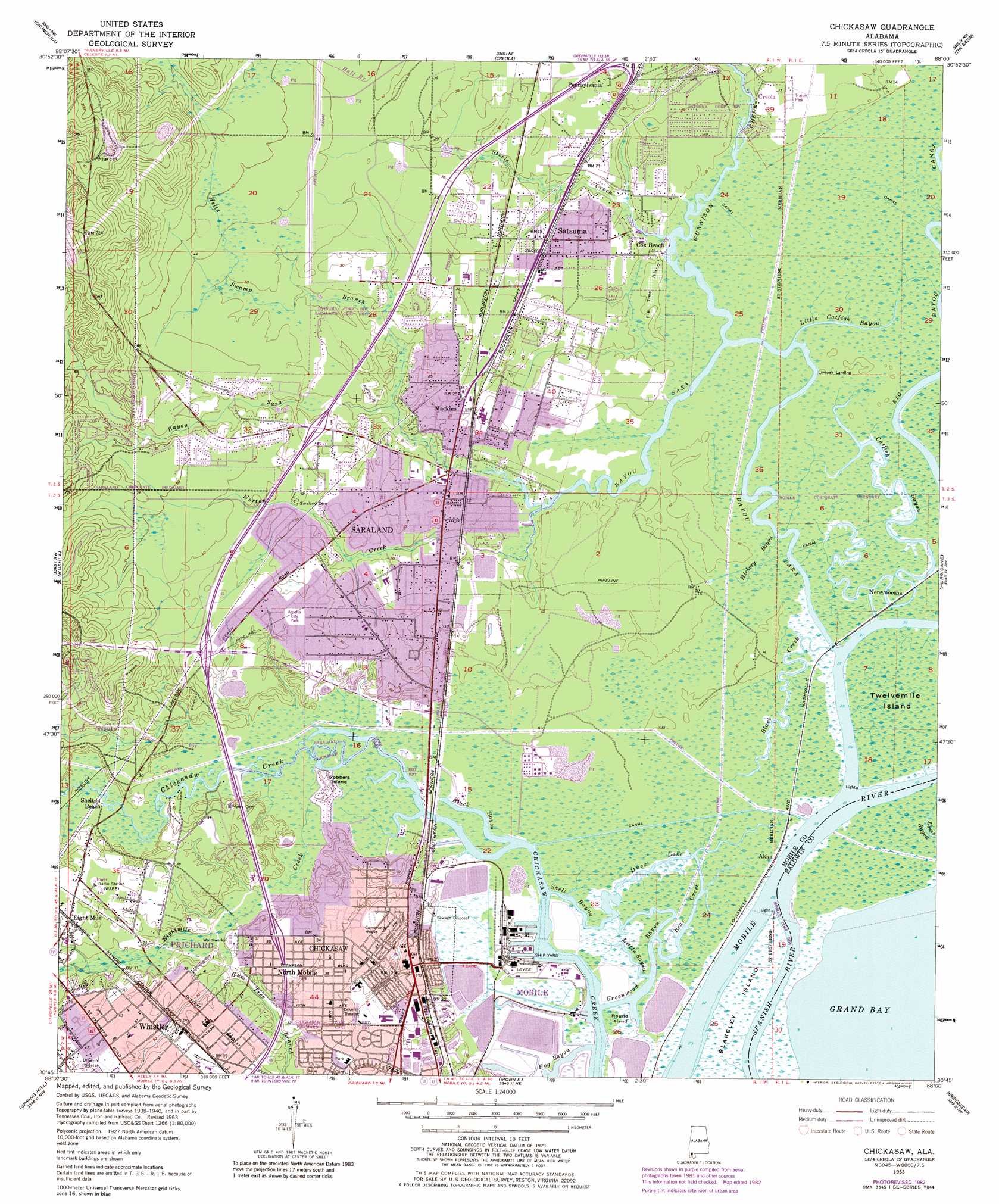
USGS Topo Quad 30088g1 - 1:24,000 scale
| Topo Map Name: | Chickasaw |
| USGS Topo Quad ID: | 30088g1 |
| Print Size: | ca. 21 1/4" wide x 27" high |
| Southeast Coordinates: | 30.75° N latitude / 88° W longitude |
| Map Center Coordinates: | 30.8125° N latitude / 88.0625° W longitude |
| U.S. State: | AL |
| Filename: | o30088g1.jpg |
| Download Map JPG Image: | Chickasaw topo map 1:24,000 scale |
| Map Type: | Topographic |
| Topo Series: | 7.5´ |
| Map Scale: | 1:24,000 |
| Source of Map Images: | United States Geological Survey (USGS) |
| Alternate Map Versions: |
Chickasaw AL 1953, updated 1955 Download PDF Buy paper map Chickasaw AL 1953, updated 1964 Download PDF Buy paper map Chickasaw AL 1953, updated 1968 Download PDF Buy paper map Chickasaw AL 1953, updated 1975 Download PDF Buy paper map Chickasaw AL 1953, updated 1983 Download PDF Buy paper map Chickasaw AL 1953, updated 1983 Download PDF Buy paper map Chickasaw AL 2011 Download PDF Buy paper map Chickasaw AL 2014 Download PDF Buy paper map |
1:24,000 Topo Quads surrounding Chickasaw
Citronelle West |
Citronelle East |
Mount Vernon |
Stiggins Lake |
Vaughn |
Georgetown |
Chunchula |
Creola |
The Basin |
Bay Minette North |
Semmes |
Kushla |
Chickasaw |
Hurricane |
Bay Minette South |
Tanner Williams |
Spring Hill |
Mobile |
Bridgehead |
Stapleton |
Saint Elmo |
Theodore |
Hollingers Island |
Daphne |
Silverhill |
> Back to 30088e1 at 1:100,000 scale
> Back to 30088a1 at 1:250,000 scale
> Back to U.S. Topo Maps home
Chickasaw topo map: Gazetteer
Chickasaw: Bays
Grand Bay elevation 0m 0′Chickasaw: Bridges
Alvarez Bridge elevation 7m 22′Bayou Sara Bridge (historical) elevation 5m 16′
Chickasaw: Canals
Chickasaw Creek Channel elevation 0m 0′Chickasaw: Crossings
Alvares Ferry (historical) elevation 2m 6′Clevelands Ferry (historical) elevation 0m 0′
Interchange 10 elevation 12m 39′
Interchange 13 elevation 11m 36′
Interchange 15 elevation 9m 29′
Chickasaw: Guts
Bear Creek elevation 0m 0′Black Bayou elevation 0m 0′
Greenwood Bayou elevation 0m 0′
Hog Bayou elevation 0m 0′
Little Bayou elevation 1m 3′
Little Catfish Bayou elevation 2m 6′
Shell Bayou elevation 0m 0′
Chickasaw: Harbors
Port of Chickasaw elevation 0m 0′Chickasaw: Islands
Fig Tree Island elevation 3m 9′Robbers Island elevation 3m 9′
Round Island elevation 1m 3′
Sam Acre Island elevation 3m 9′
Twelvemile Island elevation 1m 3′
Chickasaw: Lakes
Duck Lake elevation 2m 6′Chickasaw: Parks
Amelia City Park elevation 9m 29′Chickasabogue Park elevation 1m 3′
Joel Blackwell Memorial Field elevation 9m 29′
Norton Avenue Park elevation 6m 19′
Paul Levine Park elevation 2m 6′
Saraland Neighborhood Park elevation 16m 52′
Satsuma Lions Park elevation 6m 19′
Satsuma Municipal Park elevation 6m 19′
Chickasaw: Populated Places
Akka elevation 1m 3′Chickasaw elevation 10m 32′
College Woods elevation 22m 72′
Cox Beach elevation 3m 9′
Junior Acres elevation 5m 16′
Little Pines elevation 9m 29′
Mackies elevation 7m 22′
Mauvilla Forest Estates elevation 10m 32′
Nenemoosha elevation 1m 3′
North Mobile elevation 9m 29′
Norwood elevation 10m 32′
Oakleigh Estates elevation 11m 36′
Pennsylvania elevation 6m 19′
Pine Wood elevation 6m 19′
Saraland elevation 4m 13′
Satsuma elevation 4m 13′
Shelton Beach Estates elevation 7m 22′
Spanish Trace elevation 18m 59′
Whistler elevation 11m 36′
Williams Heights elevation 10m 32′
Chickasaw: Post Offices
Chickasaw Post Office elevation 9m 29′Satsuma Post Office elevation 4m 13′
Chickasaw: Reservoirs
Saraland Reservoir elevation 3m 9′Chickasaw: Springs
Crystal Springs elevation 1m 3′Chickasaw: Streams
Bayou Sara elevation 0m 0′Big Bayou Canot elevation 0m 0′
Black Creek elevation 1m 3′
Catfish Bayou elevation 1m 3′
Eightmile Creek elevation 0m 0′
Gum Tree Branch elevation 2m 6′
Gunnison Creek elevation 0m 0′
Hells Swamp Branch elevation 2m 6′
Hickory Bayou elevation 2m 6′
Norton Creek elevation 0m 0′
Steele Creek elevation 0m 0′
Chickasaw digital topo map on disk
Buy this Chickasaw topo map showing relief, roads, GPS coordinates and other geographical features, as a high-resolution digital map file on DVD:
Gulf Coast (LA, MS, AL, FL) & Southwestern Georgia
Buy digital topo maps: Gulf Coast (LA, MS, AL, FL) & Southwestern Georgia
 & Southwestern Georgia map DVD")