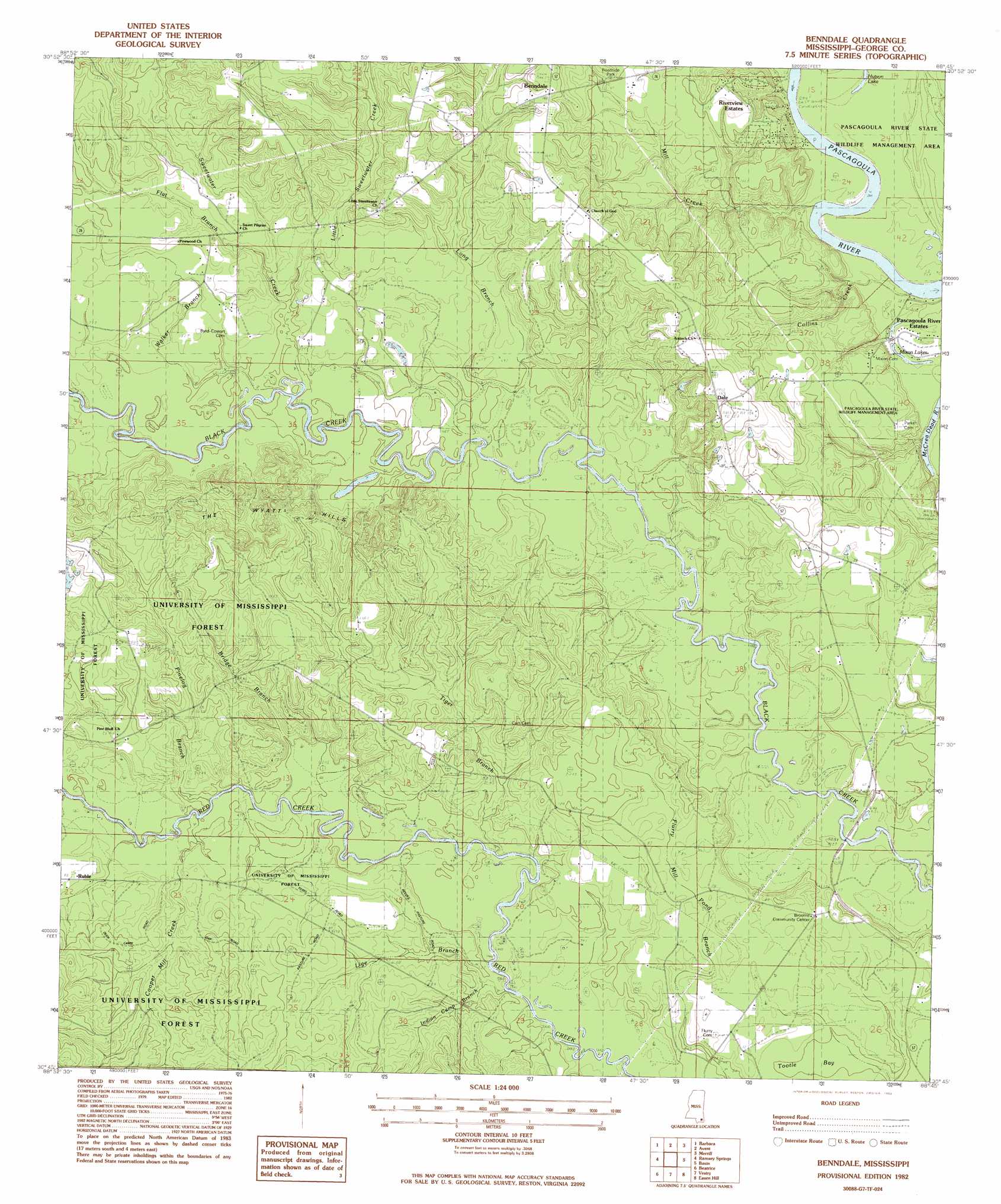
Benndale Topo Map Mississippi
To zoom in, hover over the map of Benndale
USGS Topo Quad 30088g7 - 1:24,000 scale
| Topo Map Name: | Benndale |
| USGS Topo Quad ID: | 30088g7 |
| Print Size: | ca. 21 1/4" wide x 27" high |
| Southeast Coordinates: | 30.75° N latitude / 88.75° W longitude |
| Map Center Coordinates: | 30.8125° N latitude / 88.8125° W longitude |
| U.S. State: | MS |
| Filename: | o30088g7.jpg |
| Download Map JPG Image: | Benndale topo map 1:24,000 scale |
| Map Type: | Topographic |
| Topo Series: | 7.5´ |
| Map Scale: | 1:24,000 |
| Source of Map Images: | United States Geological Survey (USGS) |
| Alternate Map Versions: |
Benndale MS 1982, updated 1982 Download PDF Buy paper map Benndale MS 2000, updated 2002 Download PDF Buy paper map Benndale MS 2012 Download PDF Buy paper map Benndale MS 2015 Download PDF Buy paper map |
| FStopo: | US Forest Service topo Benndale is available: Download FStopo PDF Download FStopo TIF |
1:24,000 Topo Quads surrounding Benndale
Janice |
Taylor Hill |
Mclain |
Leakesville Sw |
Vernal |
Bond Pond |
Barbara |
Avent |
Merrill |
Lucedale |
Whites Crossing |
Ramsey Springs |
Benndale |
Basin |
Agricola |
Airey |
Beatrice |
Vestry |
Easen Hill |
Harleston |
Success |
White Plains |
Latimer |
Vancleave |
Three Rivers |
> Back to 30088e1 at 1:100,000 scale
> Back to 30088a1 at 1:250,000 scale
> Back to U.S. Topo Maps home
Benndale topo map: Gazetteer
Benndale: Bridges
Byrd Bridge elevation 10m 32′Benndale: Cliffs
McCray Bluff elevation 25m 82′Benndale: Lakes
Hutson Lake elevation 10m 32′Mixon Lakes elevation 10m 32′
Benndale: Populated Places
Benndale elevation 49m 160′Dale elevation 49m 160′
Pascagoula River Estates elevation 9m 29′
Riverview Estates elevation 31m 101′
Ruble elevation 23m 75′
Slavonia (historical) elevation 24m 78′
Benndale: Streams
Bates Creek elevation 17m 55′Bridge Branch elevation 12m 39′
Collins Creek elevation 9m 29′
Cooper Mill Creek elevation 12m 39′
Coppermill Creek elevation 15m 49′
Flat Branch elevation 18m 59′
Indian Camp Branch elevation 12m 39′
Lige Branch elevation 11m 36′
Little Sweetwater Creek elevation 16m 52′
Long Branch elevation 12m 39′
Mill Creek elevation 9m 29′
Pinelog Branch elevation 16m 52′
Sweetwater Creek elevation 15m 49′
Walker Branch elevation 15m 49′
Benndale: Summits
The Wyatt Hills elevation 49m 160′Benndale: Swamps
Tootle Bay elevation 15m 49′Benndale digital topo map on disk
Buy this Benndale topo map showing relief, roads, GPS coordinates and other geographical features, as a high-resolution digital map file on DVD:
Gulf Coast (LA, MS, AL, FL) & Southwestern Georgia
Buy digital topo maps: Gulf Coast (LA, MS, AL, FL) & Southwestern Georgia
 & Southwestern Georgia map DVD")