Alligator Point Topo Map Louisiana
To zoom in, hover over the map of Alligator Point
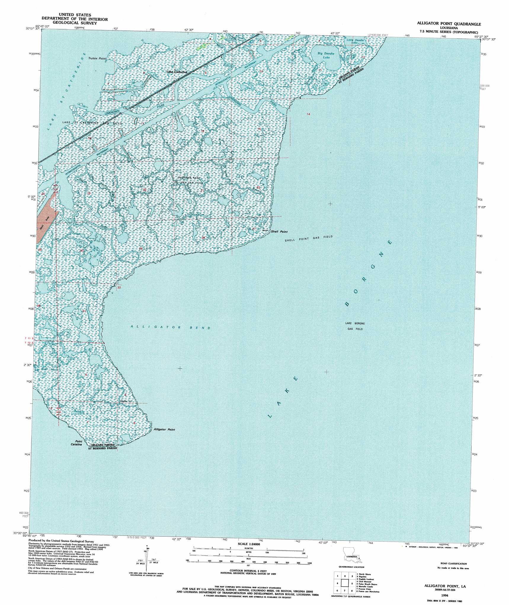
USGS Topo Quad 30089a6 - 1:24,000 scale
| Topo Map Name: | Alligator Point |
| USGS Topo Quad ID: | 30089a6 |
| Print Size: | ca. 21 1/4" wide x 27" high |
| Southeast Coordinates: | 30° N latitude / 89.625° W longitude |
| Map Center Coordinates: | 30.0625° N latitude / 89.6875° W longitude |
| U.S. State: | LA |
| Filename: | o30089a6.jpg |
| Download Map JPG Image: | Alligator Point topo map 1:24,000 scale |
| Map Type: | Topographic |
| Topo Series: | 7.5´ |
| Map Scale: | 1:24,000 |
| Source of Map Images: | United States Geological Survey (USGS) |
| Alternate Map Versions: |
Alligator Point LA 1956, updated 1960 Download PDF Buy paper map Alligator Point LA 1956, updated 1967 Download PDF Buy paper map Alligator Point LA 1968, updated 1969 Download PDF Buy paper map Alligator Point LA 1968, updated 1978 Download PDF Buy paper map Alligator Point LA 1968, updated 1991 Download PDF Buy paper map Alligator Point LA 1994, updated 1995 Download PDF Buy paper map Alligator Point LA 2012 Download PDF Buy paper map Alligator Point LA 2015 Download PDF Buy paper map |
1:24,000 Topo Quads surrounding Alligator Point
Lacombe |
Slidell |
Haaswood |
Logtown |
Waveland |
South Point |
North Shore |
Rigolets |
English Lookout |
Grand Island Pass |
Little Woods |
Chef Menteur |
Alligator Point |
False Mouth Bayou |
Malheureux Point |
Chalmette |
Martello Castle |
Proctor Point |
Pte Aux Marchettes |
Lake Eugenie |
Belle Chasse |
Delacroix |
Yscloskey |
Lena Lagoon |
Lake Eloi |
> Back to 30089a1 at 1:100,000 scale
> Back to 30088a1 at 1:250,000 scale
> Back to U.S. Topo Maps home
Alligator Point topo map: Gazetteer
Alligator Point: Bays
Alligator Bend elevation -1m -4′Alligator Point: Capes
Alligator Point elevation 1m 3′Point Cataline elevation 0m 0′
Shell Point elevation -1m -4′
Truloix Point elevation 0m 0′
Alligator Point: Channels
Unknown Pass elevation -1m -4′Alligator Point: Guts
Bayou Platte elevation -1m -4′Blind Bayou elevation 0m 0′
Bobs Bayou elevation 0m 0′
Deedie Bayou elevation -1m -4′
Frederick Bayou elevation -1m -4′
Little Bayou Platte elevation 0m 0′
Miller Bayou elevation -1m -4′
Truloix Bayou elevation 0m 0′
Alligator Point: Lakes
Big Deedie Lake elevation -1m -4′Alligator Point: Oilfields
Unknown Pass Gas Field elevation 0m 0′Alligator Point: Populated Places
Lake Catherine elevation 0m 0′Alligator Point digital topo map on disk
Buy this Alligator Point topo map showing relief, roads, GPS coordinates and other geographical features, as a high-resolution digital map file on DVD:
Gulf Coast (LA, MS, AL, FL) & Southwestern Georgia
Buy digital topo maps: Gulf Coast (LA, MS, AL, FL) & Southwestern Georgia
 & Southwestern Georgia map DVD")