Industrial Topo Map Louisiana
To zoom in, hover over the map of Industrial
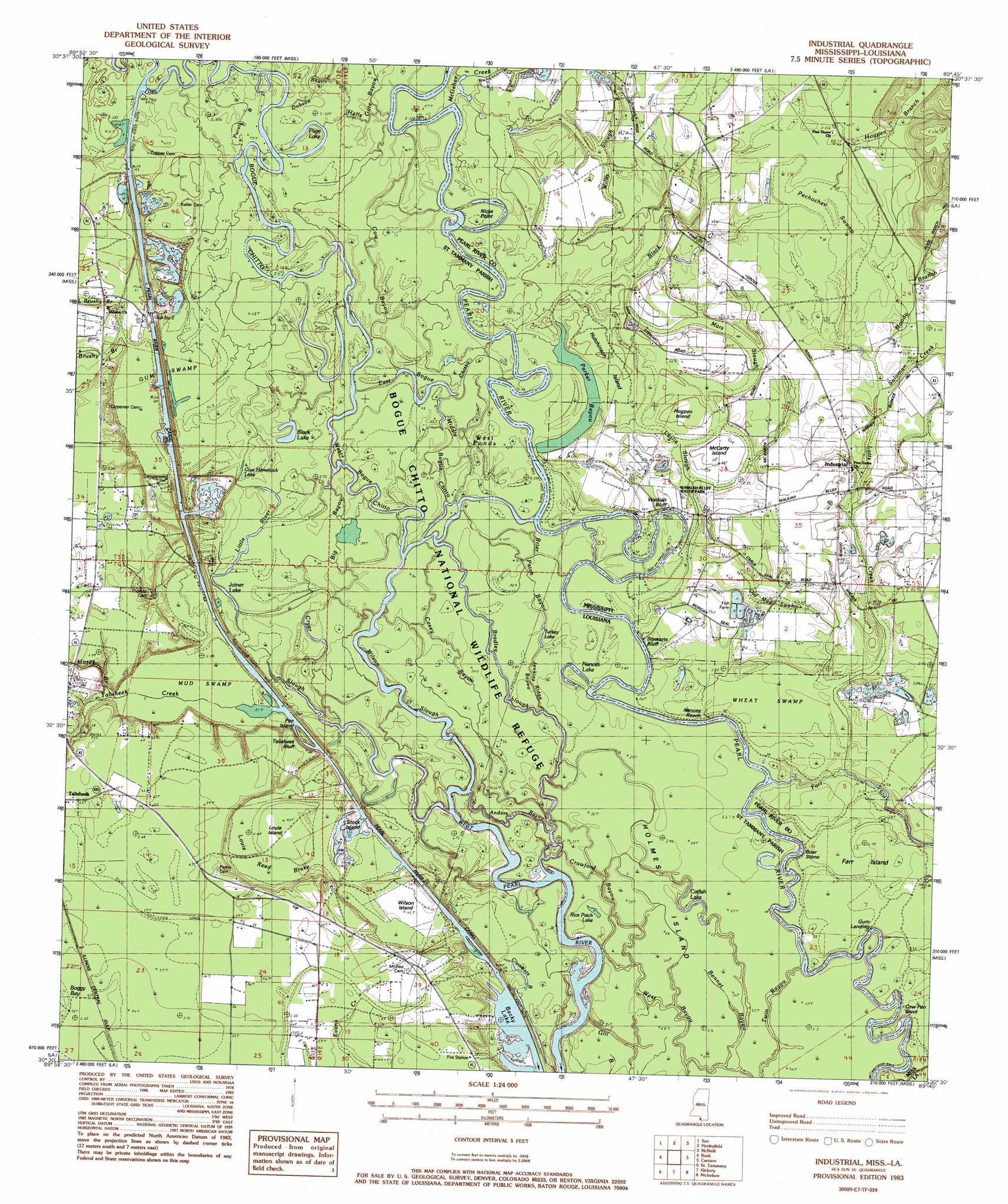
USGS Topo Quad 30089e7 - 1:24,000 scale
| Topo Map Name: | Industrial |
| USGS Topo Quad ID: | 30089e7 |
| Print Size: | ca. 21 1/4" wide x 27" high |
| Southeast Coordinates: | 30.5° N latitude / 89.75° W longitude |
| Map Center Coordinates: | 30.5625° N latitude / 89.8125° W longitude |
| U.S. States: | LA, MS |
| Filename: | o30089e7.jpg |
| Download Map JPG Image: | Industrial topo map 1:24,000 scale |
| Map Type: | Topographic |
| Topo Series: | 7.5´ |
| Map Scale: | 1:24,000 |
| Source of Map Images: | United States Geological Survey (USGS) |
| Alternate Map Versions: |
Industrial MS 1983, updated 1984 Download PDF Buy paper map Industrial MS 1983, updated 1984 Download PDF Buy paper map Industrial MS 1997, updated 1999 Download PDF Buy paper map Industrial MS 2012 Download PDF Buy paper map Industrial MS 2015 Download PDF Buy paper map |
1:24,000 Topo Quads surrounding Industrial
Sheridan |
Bogalusa West |
Bogalusa East |
White Sand |
Poplarville |
Enon |
Sun |
Henleyfield |
Mcneill |
Millard |
Waldheim |
Bush |
Industrial |
Picayune |
Caesar |
Covington |
Saint Tammany |
Hickory |
Nicholson |
Dead Tiger Creek |
Mandeville |
Lacombe |
Slidell |
Haaswood |
Logtown |
> Back to 30089e1 at 1:100,000 scale
> Back to 30088a1 at 1:250,000 scale
> Back to U.S. Topo Maps home
Industrial topo map: Gazetteer
Industrial: Areas
Farr Island elevation 10m 32′Industrial: Bends
Cow Pen Bend elevation 9m 29′Industrial: Capes
Nicks Point elevation 13m 42′Industrial: Channels
Black Creek Cutoff elevation 13m 42′Nances Reach elevation 9m 29′
Industrial: Cliffs
Stewarts Bluff elevation 13m 42′Talisheek Bluff elevation 12m 39′
Walkiah Bluff elevation 15m 49′
Industrial: Dams
Lock Number Two elevation 16m 52′Industrial: Guts
Anders Bayou elevation 8m 26′Clements Bayou elevation 8m 26′
Jenkins Ridge Bayou elevation 11m 36′
Leslie Slough elevation 13m 42′
Mars Slough elevation 14m 45′
Parker Bayou elevation 12m 39′
Willis Slough elevation 15m 49′
Industrial: Islands
Boar Stone elevation 9m 29′Circle Island elevation 12m 39′
Daves Island elevation 8m 26′
Hogpen Island elevation 14m 45′
Holmes Island elevation 9m 29′
Hutchinson Island elevation 19m 62′
Louie Island elevation 13m 42′
McCarty Island elevation 16m 52′
Parkers Hammock elevation 14m 45′
Pen Island elevation 11m 36′
Stock Island elevation 9m 29′
Wilson Island elevation 11m 36′
Industrial: Lakes
Becky Lake elevation 9m 29′Black Lake elevation 11m 36′
Catfish Lake elevation 8m 26′
Cow Hammock Lake elevation 14m 45′
Gum Pond elevation 9m 29′
Joiner Lake elevation 10m 32′
Little Cannon Lake elevation 12m 39′
Nances Lake elevation 11m 36′
Page Lake elevation 13m 42′
Rice Patch Lake elevation 7m 22′
Turkey Pond elevation 8m 26′
West Ponds elevation 11m 36′
White Oak Ridge Lake elevation 10m 32′
Industrial: Parks
Pearl River County Game Refuge elevation 14m 45′Walkiah Bluff Water Park elevation 11m 36′
Industrial: Populated Places
Industrial elevation 15m 49′Walkiah (historical) elevation 11m 36′
Industrial: Reservoirs
Pearl River Canal Pool Number Two elevation 16m 52′Industrial: Ridges
Pea Ridge elevation 31m 101′Industrial: Streams
Big Bayou elevation 12m 39′Big Creek elevation 14m 45′
Black Creek elevation 13m 42′
Bogue Chitto elevation 11m 36′
Bradley Slough elevation 7m 22′
Brier Patch Bayou elevation 8m 26′
Brushy Branch elevation 12m 39′
Byrd Bayou elevation 12m 39′
Casey Bayou elevation 8m 26′
Cow Bayou elevation 12m 39′
Crawford Bayou elevation 9m 29′
Cryer Slough elevation 10m 32′
Dobson Bayou elevation 14m 45′
East Bogue Chitto elevation 13m 42′
Hells Gate Bayou elevation 13m 42′
Hickory Creek elevation 14m 45′
Hogpen Branch elevation 18m 59′
Jarrell Creek elevation 15m 49′
Keller Bayou elevation 10m 32′
Little Brushy Branch elevation 12m 39′
Little River elevation 13m 42′
Lotts Creek elevation 11m 36′
Middle Bogue Chitto elevation 9m 29′
Moody Branch elevation 15m 49′
Moses Branch elevation 11m 36′
Parker Branch elevation 9m 29′
Purns Bayou elevation 13m 42′
Soloman Creek elevation 15m 49′
Talisheek Creek elevation 11m 36′
Twin Bayou elevation 8m 26′
West Bogue Chitto elevation 9m 29′
Wilson Slough elevation 8m 26′
Industrial: Swamps
Louie Reed Brake elevation 13m 42′Mud Swamp elevation 9m 29′
Old Mud Swamp elevation 11m 36′
Pechochen Swamp elevation 18m 59′
Wheat Swamp elevation 9m 29′
Industrial digital topo map on disk
Buy this Industrial topo map showing relief, roads, GPS coordinates and other geographical features, as a high-resolution digital map file on DVD:
Gulf Coast (LA, MS, AL, FL) & Southwestern Georgia
Buy digital topo maps: Gulf Coast (LA, MS, AL, FL) & Southwestern Georgia
 & Southwestern Georgia map DVD")