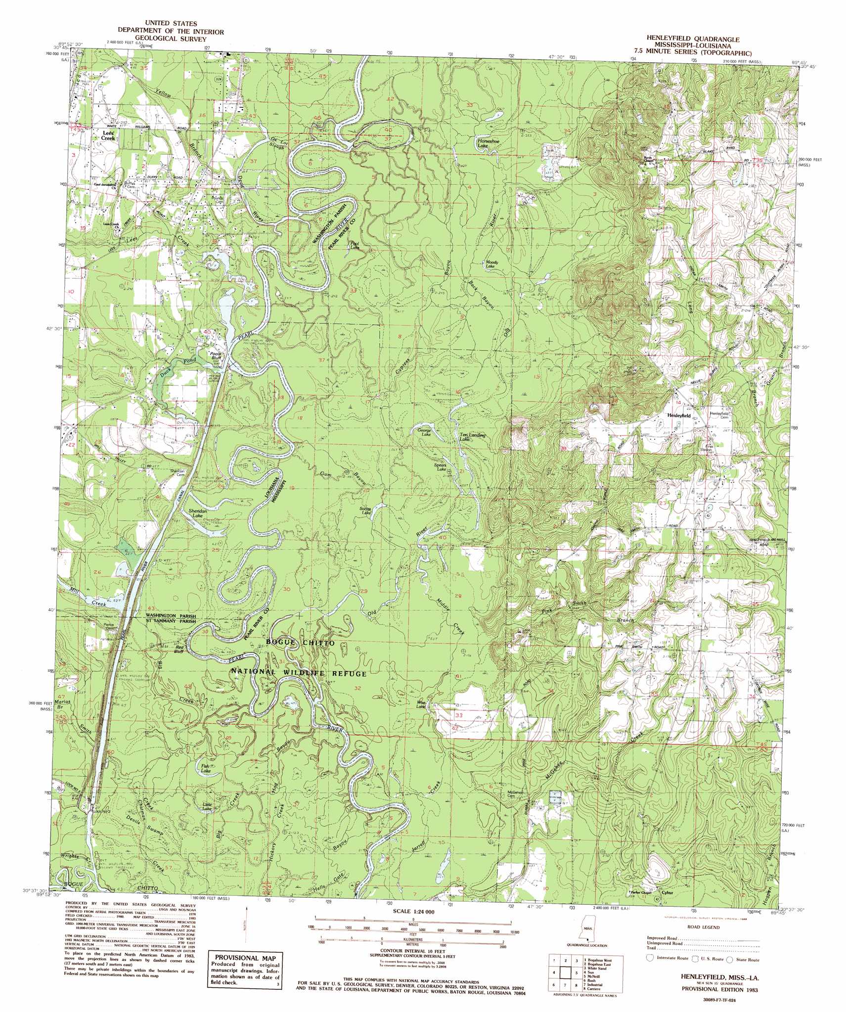
Henleyfield Topo Map Mississippi
To zoom in, hover over the map of Henleyfield
USGS Topo Quad 30089f7 - 1:24,000 scale
| Topo Map Name: | Henleyfield |
| USGS Topo Quad ID: | 30089f7 |
| Print Size: | ca. 21 1/4" wide x 27" high |
| Southeast Coordinates: | 30.625° N latitude / 89.75° W longitude |
| Map Center Coordinates: | 30.6875° N latitude / 89.8125° W longitude |
| U.S. States: | MS, LA |
| Filename: | o30089f7.jpg |
| Download Map JPG Image: | Henleyfield topo map 1:24,000 scale |
| Map Type: | Topographic |
| Topo Series: | 7.5´ |
| Map Scale: | 1:24,000 |
| Source of Map Images: | United States Geological Survey (USGS) |
| Alternate Map Versions: |
Sun NE MS 1976, updated 1977 Download PDF Buy paper map Henleyfield MS 1983, updated 1984 Download PDF Buy paper map Henleyfield MS 1983, updated 1988 Download PDF Buy paper map Henleyfield MS 2012 Download PDF Buy paper map Henleyfield MS 2015 Download PDF Buy paper map |
1:24,000 Topo Quads surrounding Henleyfield
Pine |
State Line |
Angie |
Fords Creek |
Orvisburg |
Sheridan |
Bogalusa West |
Bogalusa East |
White Sand |
Poplarville |
Enon |
Sun |
Henleyfield |
Mcneill |
Millard |
Waldheim |
Bush |
Industrial |
Picayune |
Caesar |
Covington |
Saint Tammany |
Hickory |
Nicholson |
Dead Tiger Creek |
> Back to 30089e1 at 1:100,000 scale
> Back to 30088a1 at 1:250,000 scale
> Back to U.S. Topo Maps home
Henleyfield topo map: Gazetteer
Henleyfield: Cliffs
Pools Bluff elevation 21m 68′Red Bluff elevation 17m 55′
Henleyfield: Crossings
Pools Bluff Ferry (historical) elevation 18m 59′Henleyfield: Dams
Lock Number Three elevation 15m 49′Paul Weildy Lake Dam elevation 65m 213′
Poole Bluff Sill and Pearl River Lock Three Dam elevation 19m 62′
Henleyfield: Guts
Back Bayou elevation 16m 52′Cypress Bayou elevation 18m 59′
Middle Creek elevation 15m 49′
Ox Lot Slough elevation 21m 68′
Henleyfield: Islands
Hidden Island elevation 17m 55′Henleyfield: Lakes
Duck Pond elevation 19m 62′Fish Lake elevation 17m 55′
Fish Lake elevation 15m 49′
George Lake elevation 17m 55′
Horseshoe Lake elevation 25m 82′
Little Lake elevation 14m 45′
Moody Lake elevation 19m 62′
Pool Lake elevation 19m 62′
Richardson Lake elevation 21m 68′
Sheridan Lake elevation 17m 55′
Socias Lake elevation 16m 52′
Spears Lake elevation 17m 55′
Ten Landing Lake elevation 12m 39′
Wise Lake elevation 11m 36′
Henleyfield: Parks
Bogue Chitto National Wildlife Refuge elevation 16m 52′Henleyfield: Populated Places
Chinquapin elevation 76m 249′Cybur elevation 27m 88′
Henleyfield elevation 64m 209′
Lees Creek elevation 29m 95′
Yamacraw (historical) elevation 15m 49′
Henleyfield: Reservoirs
Pearl River and Pearl River Canal Pool N elevation 19m 62′Henleyfield: Streams
Big Branch elevation 20m 65′Chatman Creek elevation 14m 45′
Dead River elevation 19m 62′
Gum Bayou elevation 16m 52′
Hog Bayou elevation 15m 49′
Lees Creek elevation 18m 59′
Marias Branch elevation 15m 49′
McGehee Creek elevation 13m 42′
Mill Creek elevation 18m 59′
Pierce Reedbreak Branch elevation 16m 52′
Pink Smith Branch elevation 11m 36′
Smith Creek elevation 14m 45′
Smith Creek elevation 16m 52′
Wrights Creek elevation 15m 49′
Yellow Branch elevation 21m 68′
Henleyfield: Swamps
Devils Swamp elevation 14m 45′Henleyfield digital topo map on disk
Buy this Henleyfield topo map showing relief, roads, GPS coordinates and other geographical features, as a high-resolution digital map file on DVD:
Gulf Coast (LA, MS, AL, FL) & Southwestern Georgia
Buy digital topo maps: Gulf Coast (LA, MS, AL, FL) & Southwestern Georgia
 & Southwestern Georgia map DVD")