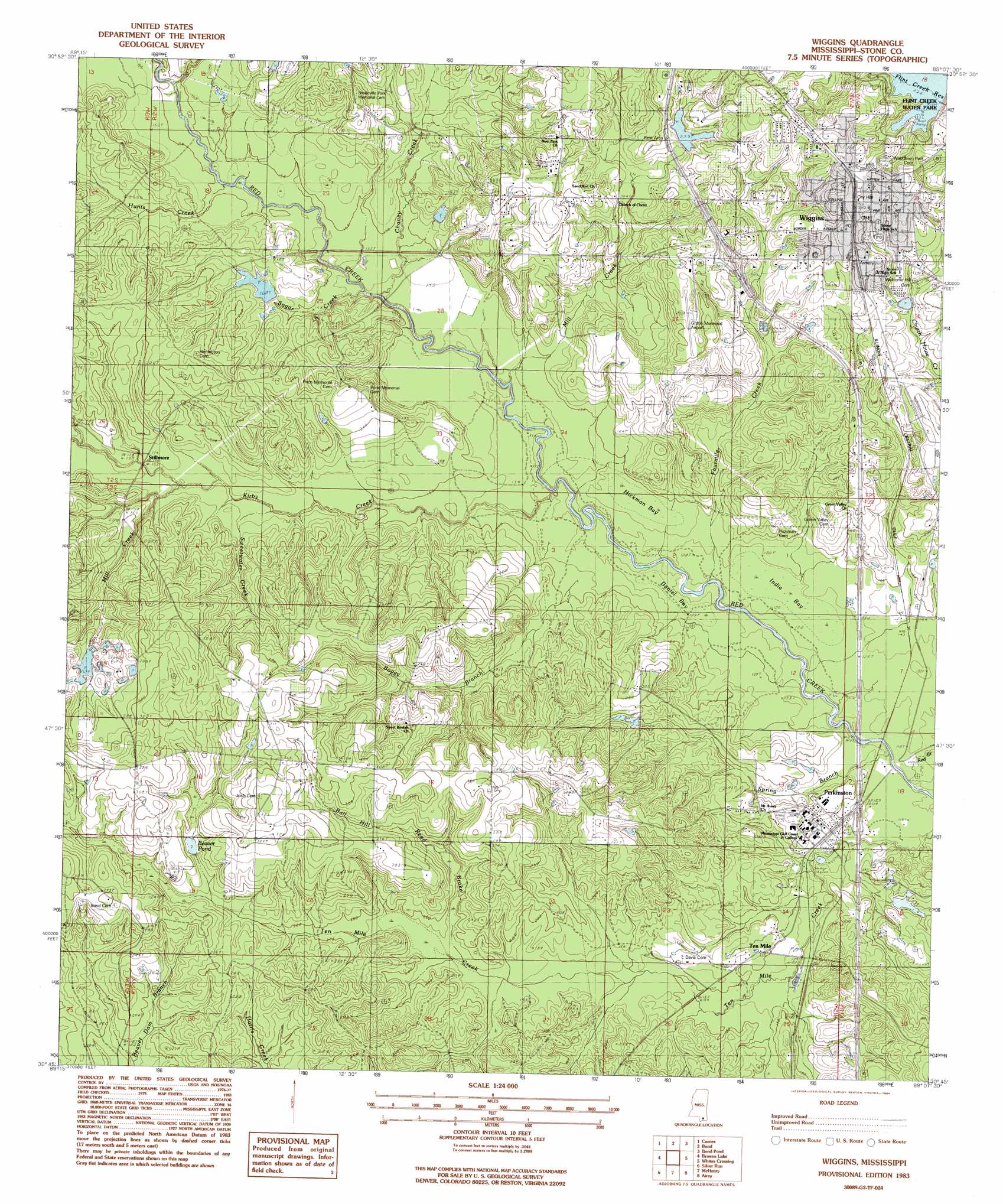
Wiggins Topo Map Mississippi
To zoom in, hover over the map of Wiggins
USGS Topo Quad 30089g2 - 1:24,000 scale
| Topo Map Name: | Wiggins |
| USGS Topo Quad ID: | 30089g2 |
| Print Size: | ca. 21 1/4" wide x 27" high |
| Southeast Coordinates: | 30.75° N latitude / 89.125° W longitude |
| Map Center Coordinates: | 30.8125° N latitude / 89.1875° W longitude |
| U.S. State: | MS |
| Filename: | o30089g2.jpg |
| Download Map JPG Image: | Wiggins topo map 1:24,000 scale |
| Map Type: | Topographic |
| Topo Series: | 7.5´ |
| Map Scale: | 1:24,000 |
| Source of Map Images: | United States Geological Survey (USGS) |
| Alternate Map Versions: |
Wiggins MS 1983, updated 1984 Download PDF Buy paper map Wiggins MS 2012 Download PDF Buy paper map Wiggins MS 2015 Download PDF Buy paper map |
1:24,000 Topo Quads surrounding Wiggins
Lumberton |
Rock Hill |
Brooklyn |
Janice |
Taylor Hill |
Hillsdale |
Carnes |
Bond |
Bond Pond |
Barbara |
Big Swamp |
Browns Lake |
Wiggins |
Whites Crossing |
Ramsey Springs |
Savannah |
Silver Run |
Mchenry |
Airey |
Beatrice |
Necaise |
Sellers |
Wortham |
Success |
White Plains |
> Back to 30089e1 at 1:100,000 scale
> Back to 30088a1 at 1:250,000 scale
> Back to U.S. Topo Maps home
Wiggins topo map: Gazetteer
Wiggins: Airports
Dean Griffin Memorial Airport elevation 78m 255′Wiggins: Dams
Albert McDonalds Lake elevation 44m 144′Browns Lake Dam elevation 54m 177′
Cuave Lake Dam elevation 57m 187′
Gyle Lake Dam elevation 77m 252′
Perkingston Lake Dam elevation 39m 127′
Perkinston Junior College Dam elevation 42m 137′
Perkinston Junior College Lake Dam elevation 43m 141′
Perkinston Junior College Lake Dam elevation 42m 137′
Remo Lake Dam elevation 52m 170′
Wiggins: Gaps
Open Gap elevation 62m 203′Wiggins: Lakes
Beaver Pond elevation 71m 232′Wiggins: Populated Places
Perkinston elevation 41m 134′Ten Mile elevation 40m 131′
Wiggins elevation 80m 262′
Wiggins: Post Offices
Wiggins Post Office elevation 84m 275′Wiggins: Reservoirs
Flint Creek Reservoir elevation 67m 219′Wiggins: Streams
Ball Hill Reed Brake elevation 59m 193′Boggy Branch elevation 37m 121′
Chaney Creek elevation 40m 131′
Four Mile Creek elevation 35m 114′
Hunts Creek elevation 43m 141′
Hunts Creek elevation 45m 147′
Kirby Creek elevation 37m 121′
Martin Creek elevation 42m 137′
Mill Creek elevation 49m 160′
Mill Creek elevation 40m 131′
Pump Branch elevation 68m 223′
Spring Branch elevation 34m 111′
Sweetwater Creek elevation 46m 150′
Tenmile Creek elevation 33m 108′
Wiggins: Swamps
Daniel Bay elevation 44m 144′Hickman Bay elevation 43m 141′
India Bay elevation 39m 127′
Wiggins digital topo map on disk
Buy this Wiggins topo map showing relief, roads, GPS coordinates and other geographical features, as a high-resolution digital map file on DVD:
Gulf Coast (LA, MS, AL, FL) & Southwestern Georgia
Buy digital topo maps: Gulf Coast (LA, MS, AL, FL) & Southwestern Georgia
 & Southwestern Georgia map DVD")