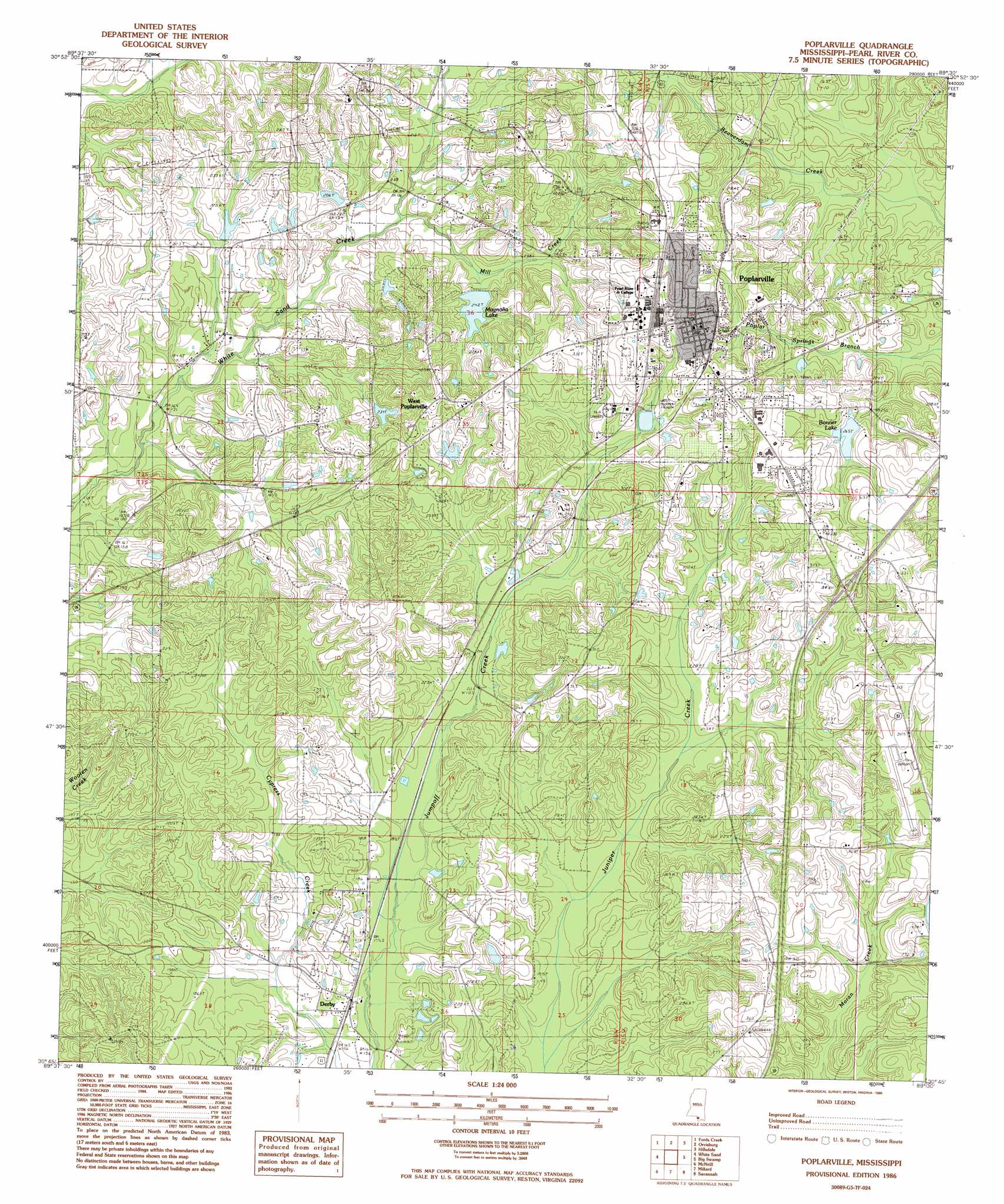
Poplarville Topo Map Mississippi
To zoom in, hover over the map of Poplarville
USGS Topo Quad 30089g5 - 1:24,000 scale
| Topo Map Name: | Poplarville |
| USGS Topo Quad ID: | 30089g5 |
| Print Size: | ca. 21 1/4" wide x 27" high |
| Southeast Coordinates: | 30.75° N latitude / 89.5° W longitude |
| Map Center Coordinates: | 30.8125° N latitude / 89.5625° W longitude |
| U.S. State: | MS |
| Filename: | o30089g5.jpg |
| Download Map JPG Image: | Poplarville topo map 1:24,000 scale |
| Map Type: | Topographic |
| Topo Series: | 7.5´ |
| Map Scale: | 1:24,000 |
| Source of Map Images: | United States Geological Survey (USGS) |
| Alternate Map Versions: |
Poplarville MS 1986, updated 1986 Download PDF Buy paper map Poplarville MS 2012 Download PDF Buy paper map Poplarville MS 2015 Download PDF Buy paper map |
1:24,000 Topo Quads surrounding Poplarville
Sandy Hook |
Baxterville Sw |
Baxterville |
Lumberton |
Rock Hill |
Angie |
Fords Creek |
Orvisburg |
Hillsdale |
Carnes |
Bogalusa East |
White Sand |
Poplarville |
Big Swamp |
Browns Lake |
Henleyfield |
Mcneill |
Millard |
Savannah |
Silver Run |
Industrial |
Picayune |
Caesar |
Necaise |
Sellers |
> Back to 30089e1 at 1:100,000 scale
> Back to 30088a1 at 1:250,000 scale
> Back to U.S. Topo Maps home
Poplarville topo map: Gazetteer
Poplarville: Airports
Poplarville-Pearl River County Airport elevation 91m 298′Poplarville: Crossings
Interchange 27 elevation 88m 288′Poplarville: Dams
B C Bonner Lake Dam elevation 76m 249′Bilbo Lake Dam elevation 81m 265′
Magnolia Lake Dam elevation 65m 213′
Piazzo Lake Dam elevation 61m 200′
Poplarville: Parks
T D Holden Stadium elevation 107m 351′Poplarville: Populated Places
Derby elevation 53m 173′Juniper Grove elevation 87m 285′
Nortac elevation 63m 206′
Poplarville elevation 97m 318′
West Poplarville elevation 94m 308′
Poplarville: Post Offices
Poplarville Post Office elevation 105m 344′Poplarville: Reservoirs
Bonner Lake elevation 76m 249′Magnolia Lake elevation 73m 239′
Poplarville: Streams
Mill Creek elevation 57m 187′Poplarville digital topo map on disk
Buy this Poplarville topo map showing relief, roads, GPS coordinates and other geographical features, as a high-resolution digital map file on DVD:
Gulf Coast (LA, MS, AL, FL) & Southwestern Georgia
Buy digital topo maps: Gulf Coast (LA, MS, AL, FL) & Southwestern Georgia
 & Southwestern Georgia map DVD")