White Sand Topo Map Mississippi
To zoom in, hover over the map of White Sand
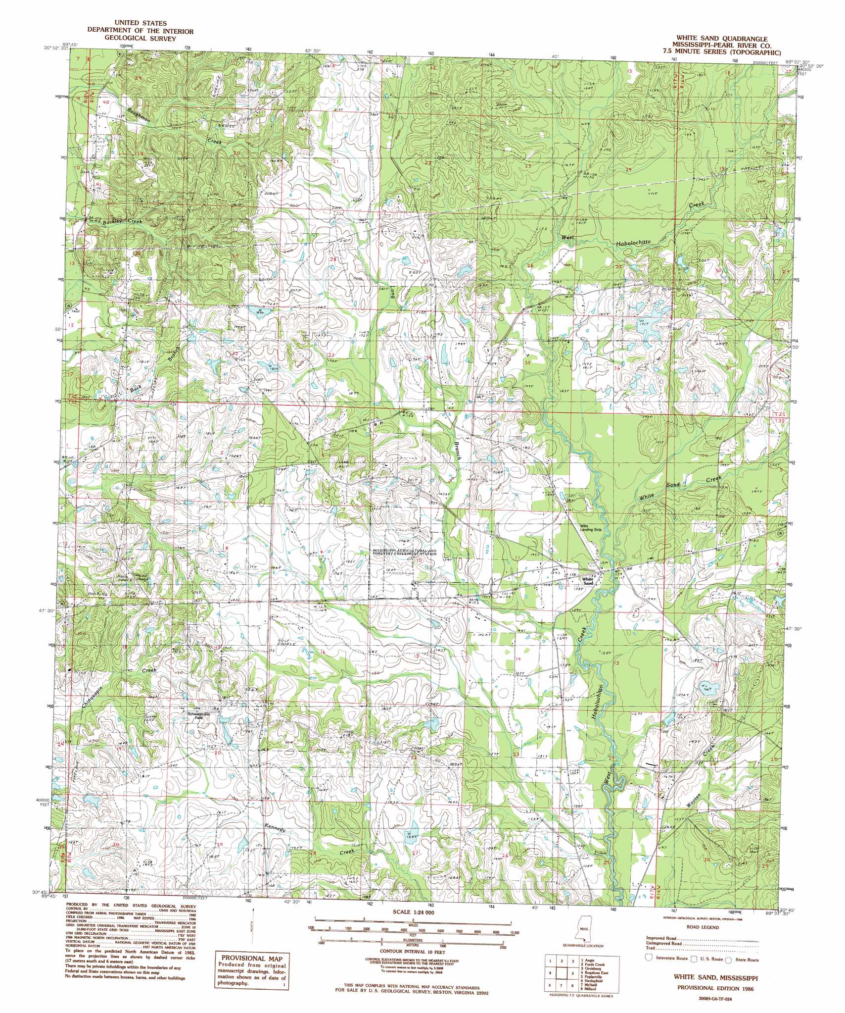
USGS Topo Quad 30089g6 - 1:24,000 scale
| Topo Map Name: | White Sand |
| USGS Topo Quad ID: | 30089g6 |
| Print Size: | ca. 21 1/4" wide x 27" high |
| Southeast Coordinates: | 30.75° N latitude / 89.625° W longitude |
| Map Center Coordinates: | 30.8125° N latitude / 89.6875° W longitude |
| U.S. State: | MS |
| Filename: | o30089g6.jpg |
| Download Map JPG Image: | White Sand topo map 1:24,000 scale |
| Map Type: | Topographic |
| Topo Series: | 7.5´ |
| Map Scale: | 1:24,000 |
| Source of Map Images: | United States Geological Survey (USGS) |
| Alternate Map Versions: |
White Sand MS 1986, updated 1986 Download PDF Buy paper map White Sand MS 2012 Download PDF Buy paper map White Sand MS 2015 Download PDF Buy paper map |
1:24,000 Topo Quads surrounding White Sand
Dexter |
Sandy Hook |
Baxterville Sw |
Baxterville |
Lumberton |
State Line |
Angie |
Fords Creek |
Orvisburg |
Hillsdale |
Bogalusa West |
Bogalusa East |
White Sand |
Poplarville |
Big Swamp |
Sun |
Henleyfield |
Mcneill |
Millard |
Savannah |
Bush |
Industrial |
Picayune |
Caesar |
Necaise |
> Back to 30089e1 at 1:100,000 scale
> Back to 30088a1 at 1:250,000 scale
> Back to U.S. Topo Maps home
White Sand topo map: Gazetteer
White Sand: Airports
Glorice P Wills Airport elevation 44m 144′White Sand: Dams
A and G Cafeteria Lake Dam elevation 64m 209′Burkley Burgess Lake Dam elevation 50m 164′
Earl Smith Lake Dam elevation 61m 200′
T Wayne Lake Dam elevation 48m 157′
Taylor Land Company Lake Dam elevation 49m 160′
White Sand: Populated Places
White Sand elevation 43m 141′White Sand: Streams
Long Branch elevation 40m 131′White Sand Creek elevation 40m 131′
White Sand digital topo map on disk
Buy this White Sand topo map showing relief, roads, GPS coordinates and other geographical features, as a high-resolution digital map file on DVD:
Gulf Coast (LA, MS, AL, FL) & Southwestern Georgia
Buy digital topo maps: Gulf Coast (LA, MS, AL, FL) & Southwestern Georgia
 & Southwestern Georgia map DVD")