Gonzales Topo Map Louisiana
To zoom in, hover over the map of Gonzales
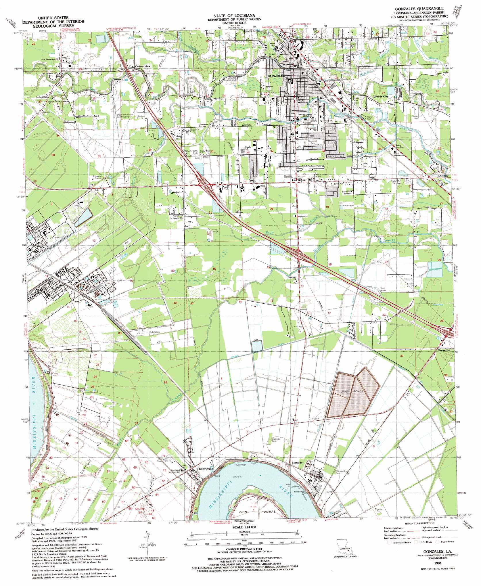
USGS Topo Quad 30090b8 - 1:24,000 scale
| Topo Map Name: | Gonzales |
| USGS Topo Quad ID: | 30090b8 |
| Print Size: | ca. 21 1/4" wide x 27" high |
| Southeast Coordinates: | 30.125° N latitude / 90.875° W longitude |
| Map Center Coordinates: | 30.1875° N latitude / 90.9375° W longitude |
| U.S. State: | LA |
| Filename: | o30090b8.jpg |
| Download Map JPG Image: | Gonzales topo map 1:24,000 scale |
| Map Type: | Topographic |
| Topo Series: | 7.5´ |
| Map Scale: | 1:24,000 |
| Source of Map Images: | United States Geological Survey (USGS) |
| Alternate Map Versions: |
Gonzales LA 1953, updated 1955 Download PDF Buy paper map Gonzales LA 1961, updated 1963 Download PDF Buy paper map Gonzales LA 1961, updated 1967 Download PDF Buy paper map Gonzales LA 1961, updated 1981 Download PDF Buy paper map Gonzales LA 1991, updated 1991 Download PDF Buy paper map Gonzales LA 1991, updated 1991 Download PDF Buy paper map Gonzales LA 1998, updated 2001 Download PDF Buy paper map Gonzales LA 2012 Download PDF Buy paper map Gonzales LA 2015 Download PDF Buy paper map |
1:24,000 Topo Quads surrounding Gonzales
Baton Rouge West |
Baton Rouge East |
Denham Springs |
Walker |
Frost |
Plaquemine |
Saint Gabriel |
Prairieville |
French Settlement |
Whitehall |
White Castle |
Carville |
Gonzales |
Sorrento |
Mount Airy Nw |
Lone Star |
Belle Rose |
Donaldsonville |
Convent |
Lutcher |
Pierre Part |
Napoleonville |
Madewood |
Lagan |
Lower Vacherie |
> Back to 30090a1 at 1:100,000 scale
> Back to 30090a1 at 1:250,000 scale
> Back to U.S. Topo Maps home
Gonzales topo map: Gazetteer
Gonzales: Airports
Double H Ranch Airport elevation 4m 13′Louisiana Regional Airport elevation 3m 9′
Riverview Medical Center Heliport elevation 3m 9′
Gonzales: Canals
Crowley Ditch elevation 1m 3′Hackett Canal elevation 2m 6′
Panama Canal elevation 1m 3′
Gonzales: Crossings
Interchange 177 elevation 4m 13′Gonzales: Levees
Aben Revetment elevation 2m 6′Marchand Revetment elevation 4m 13′
Gonzales: Oilfields
Darrow Oil Field elevation 4m 13′Gonzales: Parks
Burnside Park elevation 2m 6′Cornerview Park elevation 3m 9′
Dixie Youth Park elevation 2m 6′
George Washington Carver Park elevation 2m 6′
Gonzales Municipal Park elevation 3m 9′
Hillaryville Parish Park elevation 4m 13′
Spartan Stadium elevation 3m 9′
Gonzales: Populated Places
Belle Helene elevation 7m 22′Bowden elevation 7m 22′
Brittany elevation 2m 6′
Burnside elevation 6m 19′
Cofield elevation 7m 22′
Cornerview elevation 4m 13′
Gonzales elevation 3m 9′
Hillaryville elevation 5m 16′
Humphries (historical) elevation 6m 19′
Marchand elevation 5m 16′
Rearwood (historical) elevation 4m 13′
Weber City elevation 2m 6′
Gonzales: Post Offices
Brittany Post Office elevation 2m 6′Burnside Post Office elevation 5m 16′
Gonzales Post Office elevation 3m 9′
Gonzales: Streams
Bayou Narcisse elevation 1m 3′Boyle Bayou elevation 2m 6′
Grand Goudine Bayou elevation 3m 9′
Smith Bayou elevation 3m 9′
Gonzales digital topo map on disk
Buy this Gonzales topo map showing relief, roads, GPS coordinates and other geographical features, as a high-resolution digital map file on DVD: