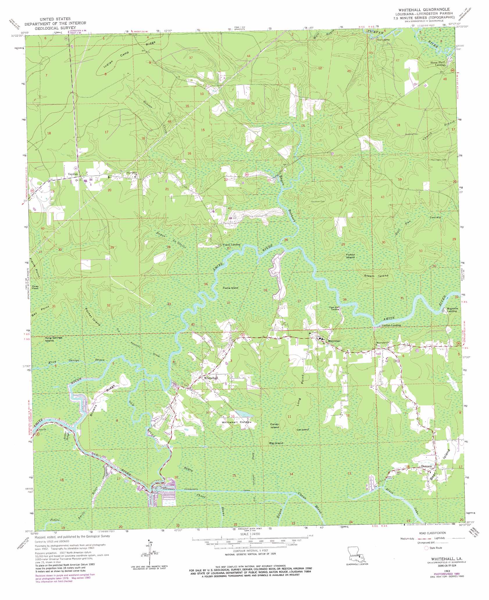
Whitehall Topo Map Louisiana
To zoom in, hover over the map of Whitehall
USGS Topo Quad 30090c6 - 1:24,000 scale
| Topo Map Name: | Whitehall |
| USGS Topo Quad ID: | 30090c6 |
| Print Size: | ca. 21 1/4" wide x 27" high |
| Southeast Coordinates: | 30.25° N latitude / 90.625° W longitude |
| Map Center Coordinates: | 30.3125° N latitude / 90.6875° W longitude |
| U.S. State: | LA |
| Filename: | o30090c6.jpg |
| Download Map JPG Image: | Whitehall topo map 1:24,000 scale |
| Map Type: | Topographic |
| Topo Series: | 7.5´ |
| Map Scale: | 1:24,000 |
| Source of Map Images: | United States Geological Survey (USGS) |
| Alternate Map Versions: |
Whitehall LA 1963, updated 1964 Download PDF Buy paper map Whitehall LA 1963, updated 1975 Download PDF Buy paper map Whitehall LA 1963, updated 1981 Download PDF Buy paper map Whitehall LA 1963, updated 1989 Download PDF Buy paper map Whitehall LA 2012 Download PDF Buy paper map Whitehall LA 2015 Download PDF Buy paper map |
1:24,000 Topo Quads surrounding Whitehall
Watson |
Satsuma |
Holden |
Albany |
Hammond |
Denham Springs |
Walker |
Frost |
Springfield |
Ponchatoula |
Prairieville |
French Settlement |
Whitehall |
Killian |
Manchac |
Gonzales |
Sorrento |
Mount Airy Nw |
Mount Airy Ne |
Ruddock |
Donaldsonville |
Convent |
Lutcher |
Reserve |
Laplace |
> Back to 30090a1 at 1:100,000 scale
> Back to 30090a1 at 1:250,000 scale
> Back to U.S. Topo Maps home
Whitehall topo map: Gazetteer
Whitehall: Areas
Whitehall Coteau elevation 2m 6′Whitehall: Canals
Chinquapin Canal elevation 2m 6′Whitehall: Capes
Bay Point elevation 1m 3′Long Point elevation 2m 6′
Whitehall: Guts
Bayou La Glaise elevation 0m 0′Whitehall: Islands
Big Island elevation 1m 3′Caney Island elevation 1m 3′
Cat Island elevation 1m 3′
Ficklin Island elevation 2m 6′
King George Island elevation 2m 6′
Poche Island elevation 0m 0′
Pocket Island elevation 2m 6′
Steam Island elevation 2m 6′
Whitehall: Lakes
Black Lake elevation 0m 0′Whitehall: Populated Places
Bayou Barbary elevation 3m 9′Catfish Landing elevation 1m 3′
Denson elevation 1m 3′
Horse Bluff Landing elevation 3m 9′
Magnolia Landing elevation 2m 6′
Maurepas elevation 1m 3′
Neal Landing elevation 1m 3′
Tiger Bluff Landing elevation 0m 0′
Union Landing elevation 3m 9′
Verdun elevation 5m 16′
Whitehall elevation 3m 9′
Whitehall: Post Offices
Maurepas Post Office elevation 4m 13′Whitehall: Ridges
Browns Ridge elevation 2m 6′Dempsey Ridge elevation 1m 3′
Whitehall: Streams
Arthur Slough elevation 0m 0′Bayou Barbary elevation 1m 3′
Beaver Creek elevation 1m 3′
Church Branch elevation 1m 3′
Dunham Bayou elevation 0m 0′
King George Bayou elevation 1m 3′
Old River elevation 0m 0′
Wall Bayou elevation 2m 6′
Whitehall: Swamps
Bull Run Swamp elevation 0m 0′Whitehall digital topo map on disk
Buy this Whitehall topo map showing relief, roads, GPS coordinates and other geographical features, as a high-resolution digital map file on DVD: