Covington Topo Map Louisiana
To zoom in, hover over the map of Covington
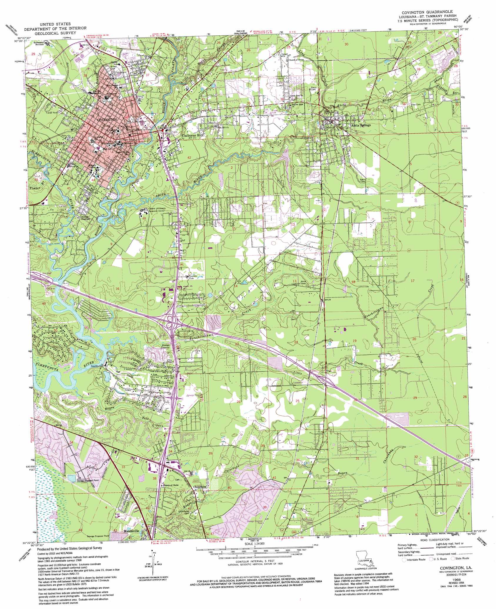
USGS Topo Quad 30090d1 - 1:24,000 scale
| Topo Map Name: | Covington |
| USGS Topo Quad ID: | 30090d1 |
| Print Size: | ca. 21 1/4" wide x 27" high |
| Southeast Coordinates: | 30.375° N latitude / 90° W longitude |
| Map Center Coordinates: | 30.4375° N latitude / 90.0625° W longitude |
| U.S. State: | LA |
| Filename: | o30090d1.jpg |
| Download Map JPG Image: | Covington topo map 1:24,000 scale |
| Map Type: | Topographic |
| Topo Series: | 7.5´ |
| Map Scale: | 1:24,000 |
| Source of Map Images: | United States Geological Survey (USGS) |
| Alternate Map Versions: |
Covington LA 1968, updated 1969 Download PDF Buy paper map Covington LA 1968, updated 1973 Download PDF Buy paper map Covington LA 1968, updated 1980 Download PDF Buy paper map Covington LA 1968, updated 1994 Download PDF Buy paper map Covington LA 1998, updated 2002 Download PDF Buy paper map Covington LA 2012 Download PDF Buy paper map Covington LA 2015 Download PDF Buy paper map |
1:24,000 Topo Quads surrounding Covington
Husser |
Folsom |
Enon |
Sun |
Henleyfield |
Robert |
Martinville |
Waldheim |
Bush |
Industrial |
Ponchatoula Ne |
Madisonville |
Covington |
Saint Tammany |
Hickory |
Ponchatoula Se |
Covington Sw |
Mandeville |
Lacombe |
Slidell |
Bonnett Carre Ne |
Spanish Fort Ne |
South Point |
North Shore |
> Back to 30090a1 at 1:100,000 scale
> Back to 30090a1 at 1:250,000 scale
> Back to U.S. Topo Maps home
Covington topo map: Gazetteer
Covington: Airports
Troop L Heliport elevation 3m 9′Covington: Crossings
Interchange 63 elevation 5m 16′Interchange 65 elevation 8m 26′
Covington: Parks
Abita Springs Historic District elevation 9m 29′Bogue Falaya Park elevation 4m 13′
Division of Saint John Historic District elevation 7m 22′
Saint Tammany Parish Fairgrounds elevation 9m 29′
Tyler Square elevation 6m 19′
Covington: Populated Places
Abita Springs elevation 9m 29′Chinchuba elevation 6m 19′
Claiborne Hill elevation 6m 19′
Covington elevation 8m 26′
Covington: Post Offices
Abita Springs Post Office elevation 9m 29′Covington Post Office elevation 6m 19′
Covington: Streams
Abita Creek elevation 7m 22′Abita River elevation 0m 0′
Bayou Tete L'Ours elevation 0m 0′
Bogue Falaya elevation 0m 0′
English Branch elevation 7m 22′
Little Bogue Falaya elevation 3m 9′
Little Creek elevation 2m 6′
Long Branch elevation 7m 22′
Mile Branch elevation 0m 0′
Ponchitolawa Creek elevation 0m 0′
Timber Branch elevation 0m 0′
Covington digital topo map on disk
Buy this Covington topo map showing relief, roads, GPS coordinates and other geographical features, as a high-resolution digital map file on DVD: