Ponchatoula Ne Topo Map Louisiana
To zoom in, hover over the map of Ponchatoula Ne
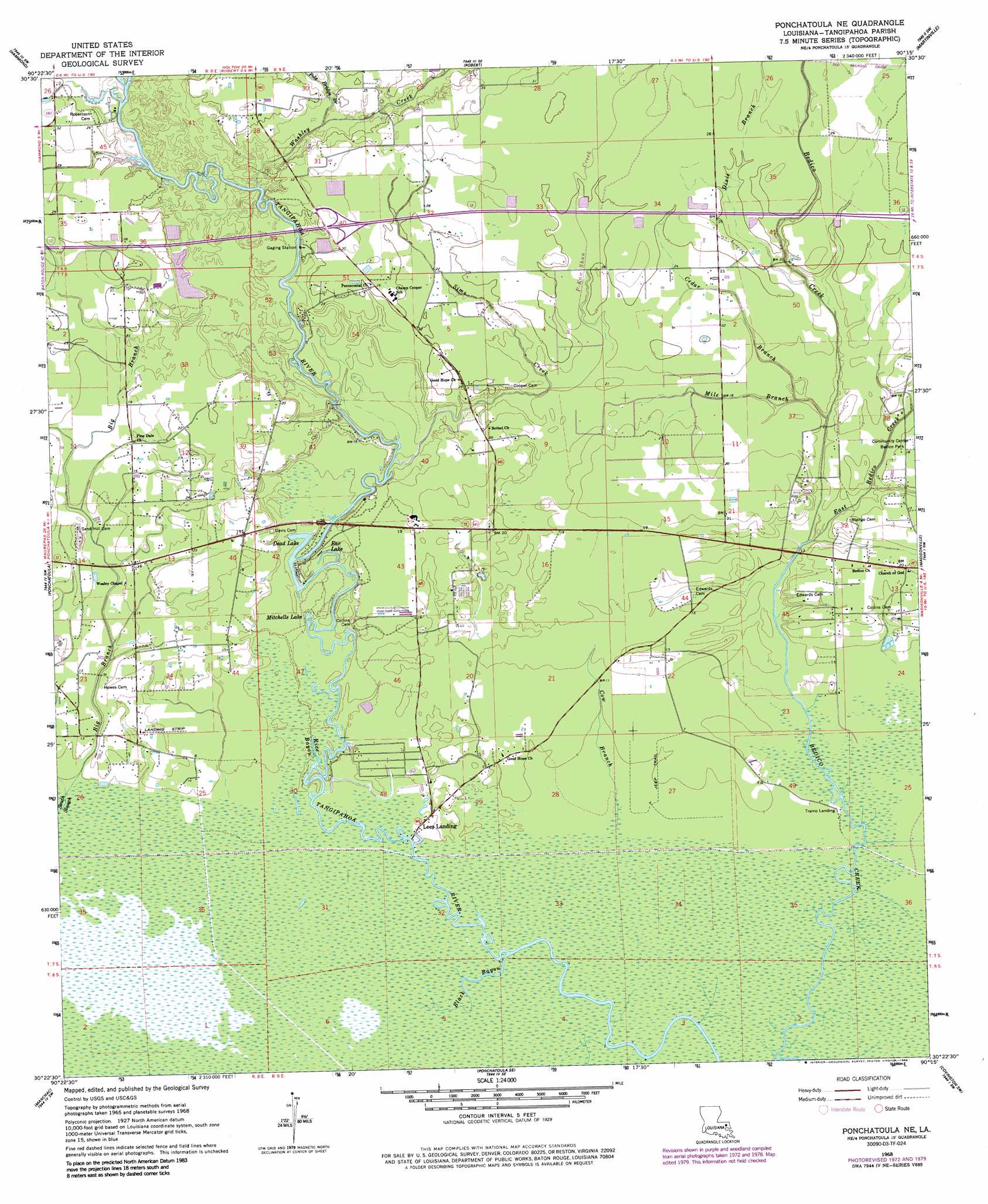
USGS Topo Quad 30090d3 - 1:24,000 scale
| Topo Map Name: | Ponchatoula Ne |
| USGS Topo Quad ID: | 30090d3 |
| Print Size: | ca. 21 1/4" wide x 27" high |
| Southeast Coordinates: | 30.375° N latitude / 90.25° W longitude |
| Map Center Coordinates: | 30.4375° N latitude / 90.3125° W longitude |
| U.S. State: | LA |
| Filename: | o30090d3.jpg |
| Download Map JPG Image: | Ponchatoula Ne topo map 1:24,000 scale |
| Map Type: | Topographic |
| Topo Series: | 7.5´ |
| Map Scale: | 1:24,000 |
| Source of Map Images: | United States Geological Survey (USGS) |
| Alternate Map Versions: |
Ponchatoula NE LA 1968, updated 1969 Download PDF Buy paper map Ponchatoula NE LA 1968, updated 1973 Download PDF Buy paper map Ponchatoula NE LA 1968, updated 1980 Download PDF Buy paper map Ponchatoula NE LA 1968, updated 1986 Download PDF Buy paper map Ponchatoula NE LA 1998, updated 2001 Download PDF Buy paper map Ponchatoula NE LA 2012 Download PDF Buy paper map Ponchatoula NE LA 2015 Download PDF Buy paper map |
1:24,000 Topo Quads surrounding Ponchatoula Ne
Amite |
Loranger |
Husser |
Folsom |
Enon |
Albany |
Hammond |
Robert |
Martinville |
Waldheim |
Springfield |
Ponchatoula |
Ponchatoula Ne |
Madisonville |
Covington |
Killian |
Manchac |
Ponchatoula Se |
Covington Sw |
Mandeville |
Mount Airy Ne |
Ruddock |
Bonnett Carre Ne |
Spanish Fort Ne |
> Back to 30090a1 at 1:100,000 scale
> Back to 30090a1 at 1:250,000 scale
> Back to U.S. Topo Maps home
Ponchatoula Ne topo map: Gazetteer
Ponchatoula Ne: Crossings
Interchange 47 elevation 9m 29′Ponchatoula Ne: Lakes
Dead Lake elevation 1m 3′Ear Lake elevation 1m 3′
Mitchells Lake elevation 0m 0′
Ponchatoula Ne: Oilfields
Mitchell Lake Gas Field elevation 6m 19′Ponchatoula Ne: Parks
Bedico Park elevation 5m 16′Ponchatoula Ne: Populated Places
Bedico elevation 6m 19′Katie (historical) elevation 4m 13′
Lees Landing elevation 1m 3′
Wallace Landing elevation 1m 3′
Ponchatoula Ne: Streams
Big Branch elevation 1m 3′Black Bayou elevation 0m 0′
Cedar Branch elevation 4m 13′
Cow Branch elevation 0m 0′
Dixie Branch elevation 5m 16′
East Bedico Creek elevation 1m 3′
Holden Branch elevation 5m 16′
Mile Branch elevation 3m 9′
P-Kaw-Shun Creek elevation 10m 32′
Pole Bridge Branch elevation 4m 13′
Rice Bayou elevation 0m 0′
Sims Creek elevation 1m 3′
Washley Creek elevation 2m 6′
Ponchatoula Ne digital topo map on disk
Buy this Ponchatoula Ne topo map showing relief, roads, GPS coordinates and other geographical features, as a high-resolution digital map file on DVD: