Ponchatoula Topo Map Louisiana
To zoom in, hover over the map of Ponchatoula
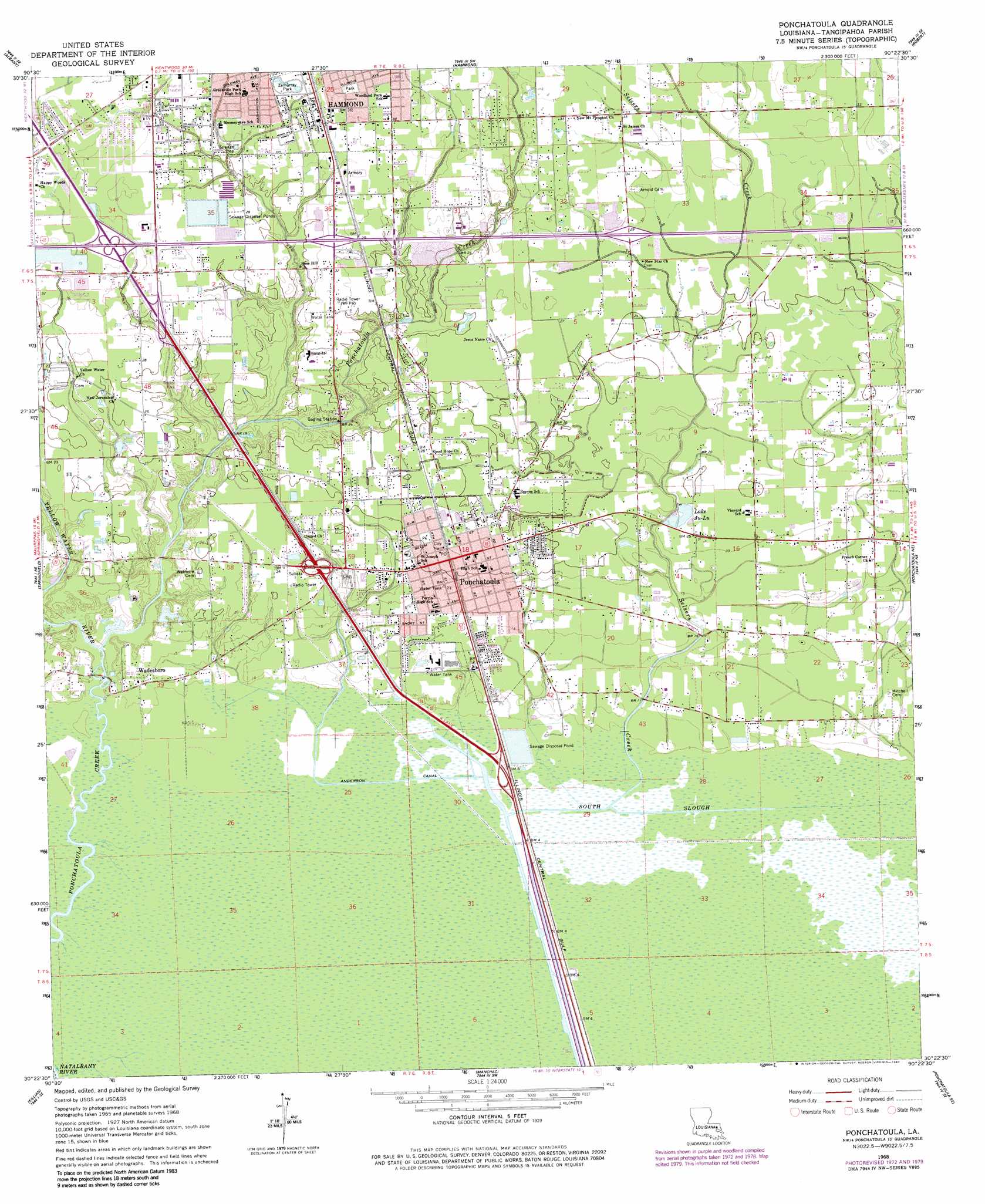
USGS Topo Quad 30090d4 - 1:24,000 scale
| Topo Map Name: | Ponchatoula |
| USGS Topo Quad ID: | 30090d4 |
| Print Size: | ca. 21 1/4" wide x 27" high |
| Southeast Coordinates: | 30.375° N latitude / 90.375° W longitude |
| Map Center Coordinates: | 30.4375° N latitude / 90.4375° W longitude |
| U.S. State: | LA |
| Filename: | o30090d4.jpg |
| Download Map JPG Image: | Ponchatoula topo map 1:24,000 scale |
| Map Type: | Topographic |
| Topo Series: | 7.5´ |
| Map Scale: | 1:24,000 |
| Source of Map Images: | United States Geological Survey (USGS) |
| Alternate Map Versions: |
Ponchatoula LA 1968, updated 1969 Download PDF Buy paper map Ponchatoula LA 1968, updated 1973 Download PDF Buy paper map Ponchatoula LA 1968, updated 1980 Download PDF Buy paper map Ponchatoula LA 1994, updated 1996 Download PDF Buy paper map Ponchatoula LA 2012 Download PDF Buy paper map Ponchatoula LA 2015 Download PDF Buy paper map |
1:24,000 Topo Quads surrounding Ponchatoula
Montpelier |
Amite |
Loranger |
Husser |
Folsom |
Holden |
Albany |
Hammond |
Robert |
Martinville |
Frost |
Springfield |
Ponchatoula |
Ponchatoula Ne |
Madisonville |
Whitehall |
Killian |
Manchac |
Ponchatoula Se |
Covington Sw |
Mount Airy Nw |
Mount Airy Ne |
Ruddock |
Bonnett Carre Ne |
> Back to 30090a1 at 1:100,000 scale
> Back to 30090a1 at 1:250,000 scale
> Back to U.S. Topo Maps home
Ponchatoula topo map: Gazetteer
Ponchatoula: Airports
Seventh Ward General Hospital Heliport elevation 8m 26′Westpark Community Hospital Heliport elevation 10m 32′
Ponchatoula: Canals
Anderson Canal elevation 0m 0′Ponchatoula: Crossings
Interchange 23 elevation 2m 6′Interchange 26 elevation 7m 22′
Interchange 28 elevation 8m 26′
Interchange 29 elevation 8m 26′
Interchange 38 elevation 10m 32′
Interchange 40 elevation 10m 32′
Interchange 42 elevation 9m 29′
Ponchatoula: Dams
Hoovers Pond Dam elevation 7m 22′Oxidation Pond Number One Dam elevation 10m 32′
Ponchatoula: Lakes
Lake Ju-Lu elevation 5m 16′Ponchatoula: Parks
Ponchatoula Commercial Historic District elevation 8m 26′Zemurray Park elevation 10m 32′
Ponchatoula: Populated Places
Avalon Terrace elevation 11m 36′Bonaire Estates elevation 8m 26′
Campbell elevation 8m 26′
Cypress Cove elevation 11m 36′
Happy Woods elevation 8m 26′
Jena (historical) elevation 2m 6′
Lakewood (historical) elevation 13m 42′
Oliver elevation 11m 36′
Ponchatoula elevation 8m 26′
Southwood Ridge elevation 9m 29′
Villa Roma elevation 11m 36′
Villa West elevation 11m 36′
Wadesboro elevation 4m 13′
Ponchatoula: Post Offices
Ponchatoula Post Office elevation 8m 26′Ponchatoula: Reservoirs
Hoovers Pond elevation 7m 22′Ponchatoula: Streams
Selsers Creek elevation 1m 3′South Slough elevation 0m 0′
Yellow Water River elevation 1m 3′
Ponchatoula: Swamps
Four Mile Marsh elevation 0m 0′Ponchatoula digital topo map on disk
Buy this Ponchatoula topo map showing relief, roads, GPS coordinates and other geographical features, as a high-resolution digital map file on DVD: