Franklinton Topo Map Louisiana
To zoom in, hover over the map of Franklinton
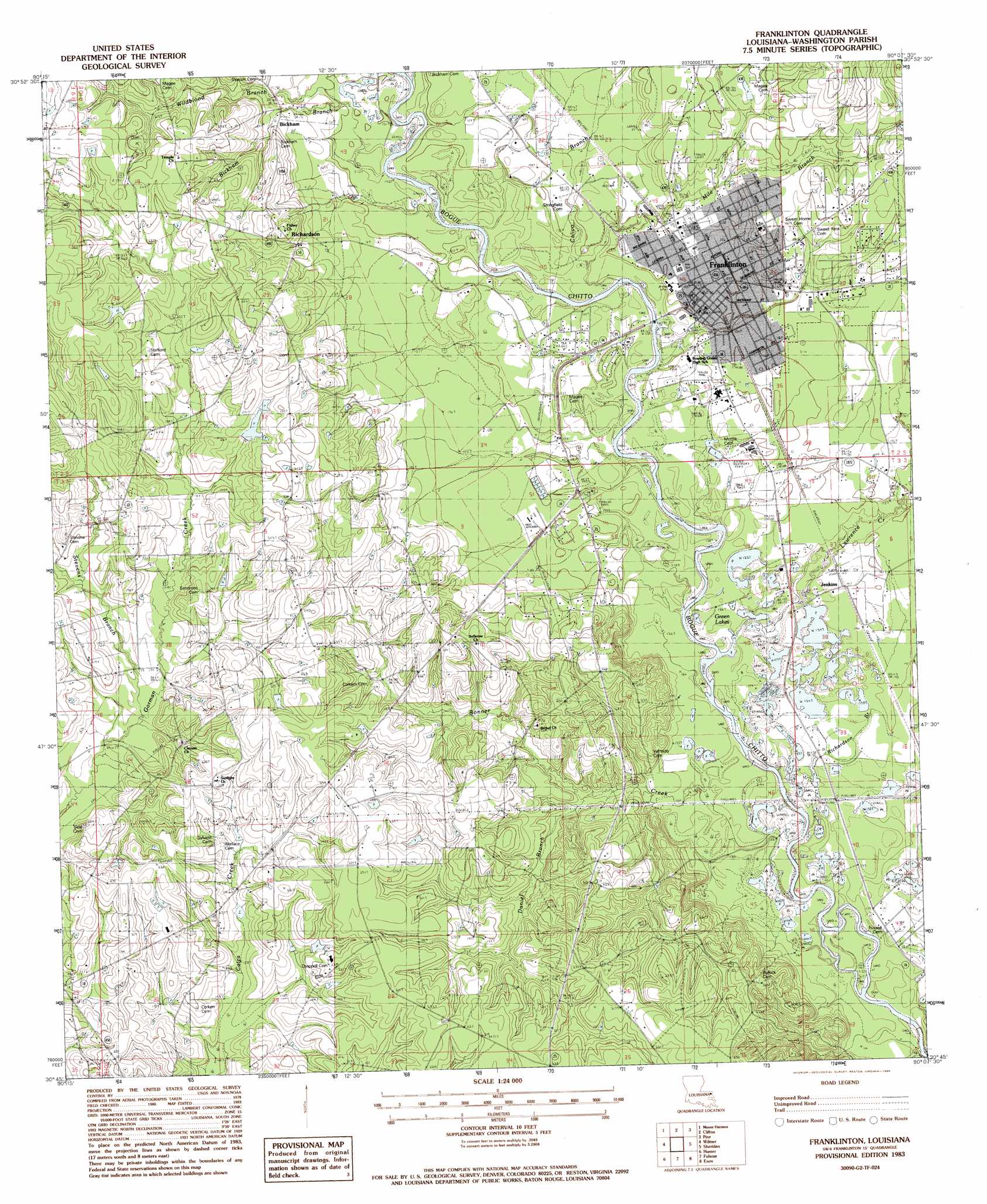
USGS Topo Quad 30090g2 - 1:24,000 scale
| Topo Map Name: | Franklinton |
| USGS Topo Quad ID: | 30090g2 |
| Print Size: | ca. 21 1/4" wide x 27" high |
| Southeast Coordinates: | 30.75° N latitude / 90.125° W longitude |
| Map Center Coordinates: | 30.8125° N latitude / 90.1875° W longitude |
| U.S. State: | LA |
| Filename: | o30090g2.jpg |
| Download Map JPG Image: | Franklinton topo map 1:24,000 scale |
| Map Type: | Topographic |
| Topo Series: | 7.5´ |
| Map Scale: | 1:24,000 |
| Source of Map Images: | United States Geological Survey (USGS) |
| Alternate Map Versions: |
Franklinton SW LA 1976, updated 1977 Download PDF Buy paper map Franklinton LA 1983, updated 1984 Download PDF Buy paper map Franklinton LA 1983, updated 1986 Download PDF Buy paper map Franklinton LA 2012 Download PDF Buy paper map Franklinton LA 2015 Download PDF Buy paper map |
1:24,000 Topo Quads surrounding Franklinton
Osyka |
Progress |
Tylertown |
Tylertown Se |
Dexter |
Spring Creek |
Sunny Hill |
Clifton |
Pine |
State Line |
Bolivar |
Wilmer |
Franklinton |
Sheridan |
Bogalusa West |
Loranger |
Husser |
Folsom |
Enon |
Sun |
Hammond |
Robert |
Martinville |
Waldheim |
Bush |
> Back to 30090e1 at 1:100,000 scale
> Back to 30090a1 at 1:250,000 scale
> Back to U.S. Topo Maps home
Franklinton topo map: Gazetteer
Franklinton: Dams
Dairy Experiment Station SE La Dam elevation 70m 229′Erwins Pond Dam elevation 71m 232′
Fussell Pond Dam elevation 79m 259′
Smith Pond Number Two Dam elevation 58m 190′
Franklinton: Lakes
Green Lakes elevation 39m 127′Franklinton: Populated Places
Bickham elevation 64m 209′Franklinton elevation 47m 154′
Jenkins elevation 45m 147′
Richardson elevation 60m 196′
Franklinton: Post Offices
Franklinton Post Office elevation 47m 154′Franklinton: Streams
Bickham Branch elevation 42m 137′Bonner Creek elevation 35m 114′
Calico Branch elevation 41m 134′
Daniel Branch elevation 40m 131′
Green Branch elevation 34m 111′
Lawrence Creek elevation 36m 118′
Mile Branch elevation 42m 137′
Richardson Branch elevation 36m 118′
Stevens Branch elevation 50m 164′
Franklinton digital topo map on disk
Buy this Franklinton topo map showing relief, roads, GPS coordinates and other geographical features, as a high-resolution digital map file on DVD: