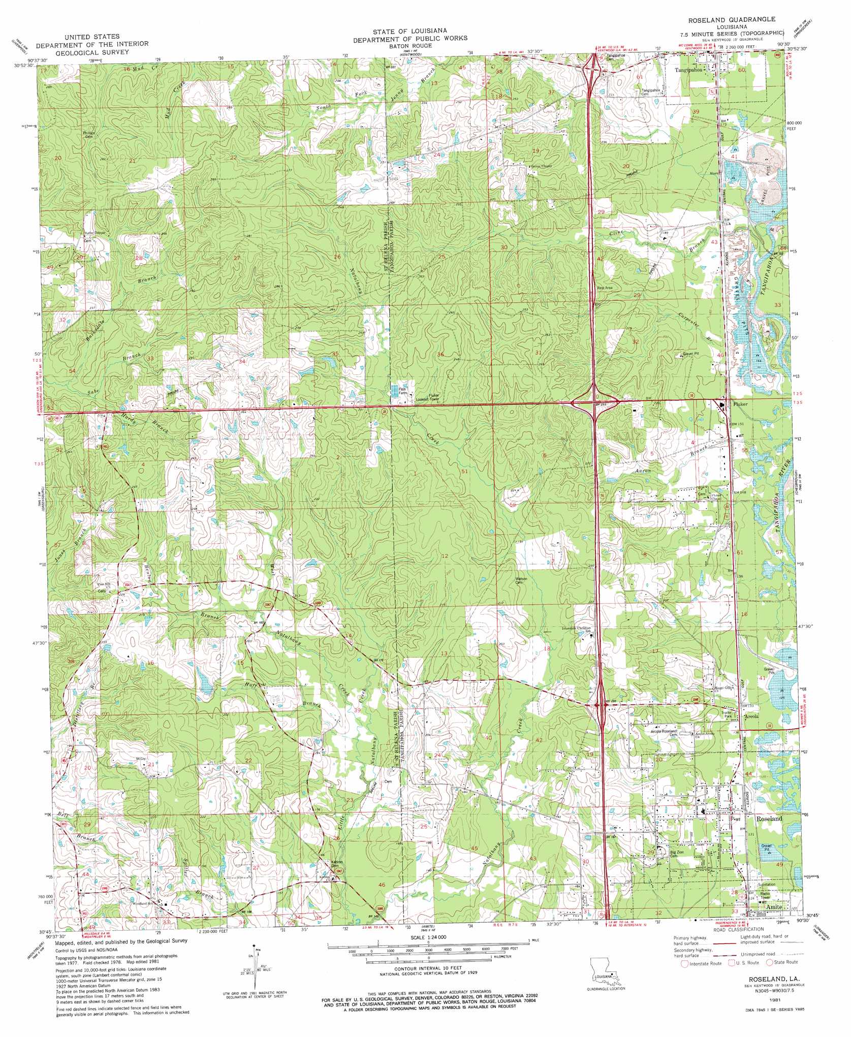
Roseland Topo Map Louisiana
To zoom in, hover over the map of Roseland
USGS Topo Quad 30090g5 - 1:24,000 scale
| Topo Map Name: | Roseland |
| USGS Topo Quad ID: | 30090g5 |
| Print Size: | ca. 21 1/4" wide x 27" high |
| Southeast Coordinates: | 30.75° N latitude / 90.5° W longitude |
| Map Center Coordinates: | 30.8125° N latitude / 90.5625° W longitude |
| U.S. State: | LA |
| Filename: | o30090g5.jpg |
| Download Map JPG Image: | Roseland topo map 1:24,000 scale |
| Map Type: | Topographic |
| Topo Series: | 7.5´ |
| Map Scale: | 1:24,000 |
| Source of Map Images: | United States Geological Survey (USGS) |
| Alternate Map Versions: |
Roseland LA 1981, updated 1981 Download PDF Buy paper map Roseland LA 1981, updated 1981 Download PDF Buy paper map Roseland LA 2012 Download PDF Buy paper map Roseland LA 2015 Download PDF Buy paper map |
1:24,000 Topo Quads surrounding Roseland
Street |
Gillsburg |
Terrys Creek |
Osyka |
Progress |
Chipola |
Liverpool |
Kentwood |
Spring Creek |
Sunny Hill |
Hatchersville |
Greensburg |
Roseland |
Bolivar |
Wilmer |
Pine Grove |
Montpelier |
Amite |
Loranger |
Husser |
Satsuma |
Holden |
Albany |
Hammond |
Robert |
> Back to 30090e1 at 1:100,000 scale
> Back to 30090a1 at 1:250,000 scale
> Back to U.S. Topo Maps home
Roseland topo map: Gazetteer
Roseland: Crossings
Interchange 50 elevation 64m 209′Interchange 53 elevation 71m 232′
Interchange 57 elevation 68m 223′
Roseland: Dams
Eiland Lake Dam elevation 81m 265′Louisiana Noname 107 Dam elevation 66m 216′
Roseland: Populated Places
Arcola elevation 41m 134′Day elevation 52m 170′
Fluker elevation 46m 150′
Kedron elevation 45m 147′
Mitchell elevation 50m 164′
Roseland elevation 40m 131′
Roseland: Post Offices
Fluker Post Office elevation 46m 150′Roseland Post Office elevation 41m 134′
Roseland: Reservoirs
Robinson Pond elevation 66m 216′Roseland: Streams
Aaron Branch elevation 43m 141′Barksdale Branch elevation 54m 177′
Benton Branch elevation 53m 173′
Carpenter Branch elevation 37m 121′
Cline Branch elevation 45m 147′
Hardy Branch elevation 57m 187′
Huff Branch elevation 46m 150′
Spring Branch elevation 41m 134′
West Natalbany Creek elevation 48m 157′
Roseland digital topo map on disk
Buy this Roseland topo map showing relief, roads, GPS coordinates and other geographical features, as a high-resolution digital map file on DVD: