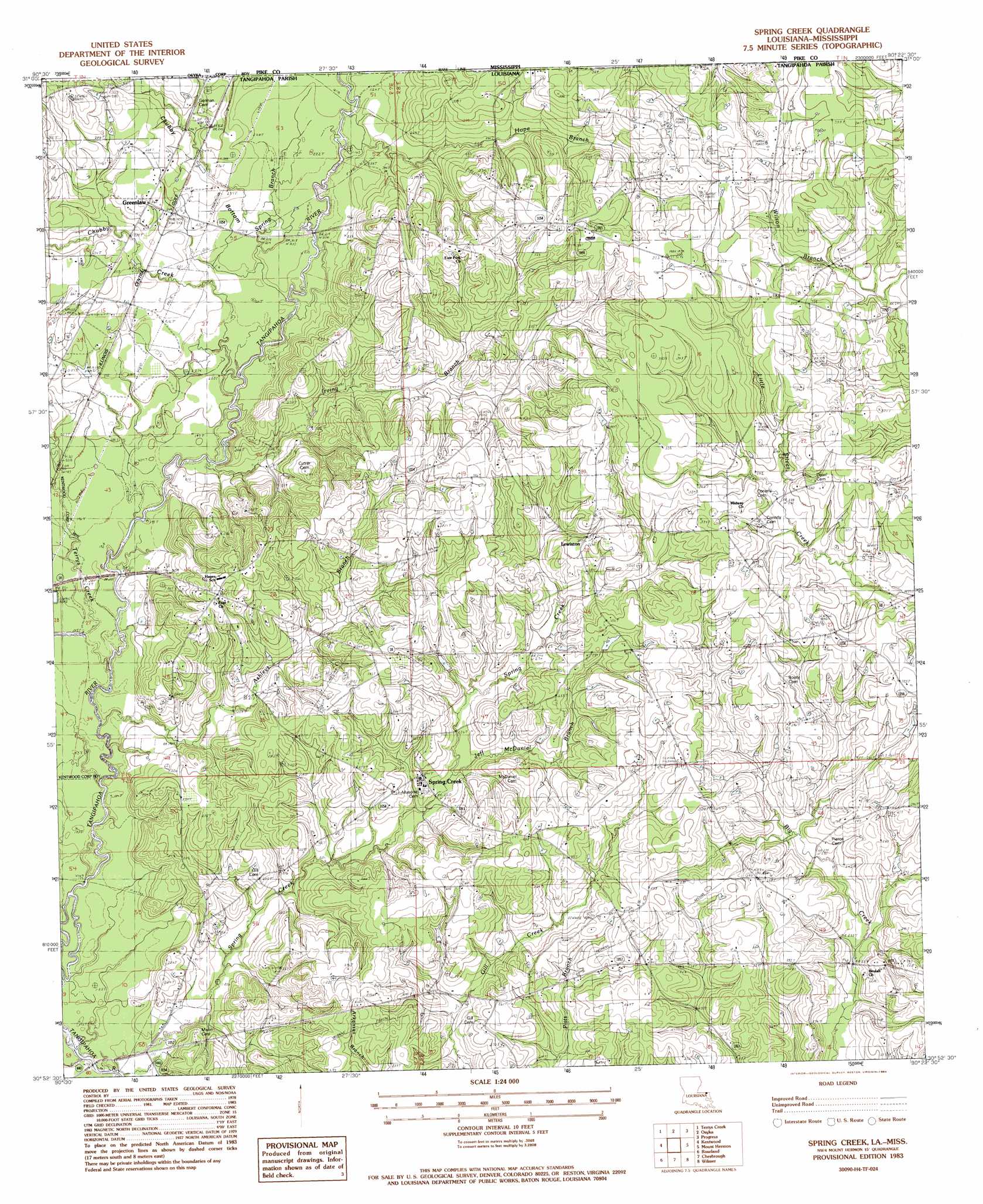
Spring Creek Topo Map Louisiana
To zoom in, hover over the map of Spring Creek
USGS Topo Quad 30090h4 - 1:24,000 scale
| Topo Map Name: | Spring Creek |
| USGS Topo Quad ID: | 30090h4 |
| Print Size: | ca. 21 1/4" wide x 27" high |
| Southeast Coordinates: | 30.875° N latitude / 90.375° W longitude |
| Map Center Coordinates: | 30.9375° N latitude / 90.4375° W longitude |
| U.S. States: | LA, MS |
| Filename: | o30090h4.jpg |
| Download Map JPG Image: | Spring Creek topo map 1:24,000 scale |
| Map Type: | Topographic |
| Topo Series: | 7.5´ |
| Map Scale: | 1:24,000 |
| Source of Map Images: | United States Geological Survey (USGS) |
| Alternate Map Versions: |
Spring Creek LA 1983, updated 1984 Download PDF Buy paper map Spring Creek LA 2012 Download PDF Buy paper map Spring Creek LA 2015 Download PDF Buy paper map |
1:24,000 Topo Quads surrounding Spring Creek
Peoria |
Lake Tangipahoa |
Mccomb South |
Holmesville |
Mesa |
Gillsburg |
Terrys Creek |
Osyka |
Progress |
Tylertown |
Liverpool |
Kentwood |
Spring Creek |
Sunny Hill |
Clifton |
Greensburg |
Roseland |
Bolivar |
Wilmer |
Franklinton |
Montpelier |
Amite |
Loranger |
Husser |
Folsom |
> Back to 30090e1 at 1:100,000 scale
> Back to 30090a1 at 1:250,000 scale
> Back to U.S. Topo Maps home
Spring Creek topo map: Gazetteer
Spring Creek: Dams
Louisiana Noname 117 Dam elevation 83m 272′Louisiana Noname 17 Dam elevation 65m 213′
Spring Creek: Oilfields
Greenlaw Oil Field elevation 65m 213′Spring Creek: Populated Places
Greenlaw elevation 79m 259′Kirkville (historical) elevation 74m 242′
Lewiston elevation 92m 301′
Spring Creek elevation 75m 246′
Spring Creek: Streams
Ashleys Branch elevation 55m 180′Bala Chitto Creek elevation 67m 219′
Beaver Creek elevation 47m 154′
Chubby Creek elevation 62m 203′
Cool Creek elevation 59m 193′
Hope Branch elevation 64m 209′
Irving Branch elevation 59m 193′
Jeff McDaniel Branch elevation 68m 223′
Spring Branch elevation 64m 209′
Spring Branch elevation 62m 203′
Spring Creek elevation 49m 160′
Terrys Creek elevation 55m 180′
Terrys Creek elevation 55m 180′
Spring Creek: Valleys
Chubby Bottom elevation 64m 209′Spring Creek digital topo map on disk
Buy this Spring Creek topo map showing relief, roads, GPS coordinates and other geographical features, as a high-resolution digital map file on DVD: