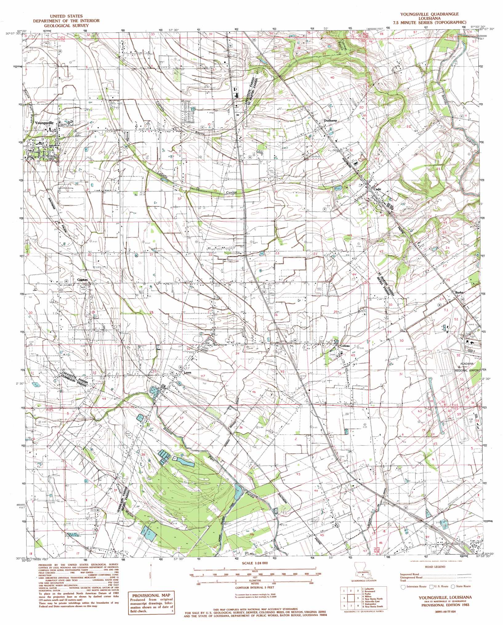
Youngsville Topo Map Louisiana
To zoom in, hover over the map of Youngsville
USGS Topo Quad 30091a8 - 1:24,000 scale
| Topo Map Name: | Youngsville |
| USGS Topo Quad ID: | 30091a8 |
| Print Size: | ca. 21 1/4" wide x 27" high |
| Southeast Coordinates: | 30° N latitude / 91.875° W longitude |
| Map Center Coordinates: | 30.0625° N latitude / 91.9375° W longitude |
| U.S. State: | LA |
| Filename: | o30091a8.jpg |
| Download Map JPG Image: | Youngsville topo map 1:24,000 scale |
| Map Type: | Topographic |
| Topo Series: | 7.5´ |
| Map Scale: | 1:24,000 |
| Source of Map Images: | United States Geological Survey (USGS) |
| Alternate Map Versions: |
Youngsville LA 1983, updated 1983 Download PDF Buy paper map Youngsville LA 2012 Download PDF Buy paper map Youngsville LA 2015 Download PDF Buy paper map |
1:24,000 Topo Quads surrounding Youngsville
Mire |
Carencro |
Breaux Bridge |
Cecilia |
Butte La Rose |
Duson |
Lafayette |
Broussard |
Parks |
Catahoula |
Leroy |
Milton |
Youngsville |
New Iberia North |
Loreauville |
Abbeville West |
Abbeville East |
Delcambre |
New Iberia South |
Jeanerette |
Intracoastal City |
Hebert Lake |
Tigre Lagoon |
Weeks |
Kemper |
> Back to 30091a1 at 1:100,000 scale
> Back to 30090a1 at 1:250,000 scale
> Back to U.S. Topo Maps home
Youngsville topo map: Gazetteer
Youngsville: Airports
Acadiana Regional Airport elevation 6m 19′Air Logistics 2 Heliport elevation 8m 26′
Air Logistics Heliport elevation 8m 26′
Sky Ranch Airport elevation 4m 13′
Youngsville: Canals
Romero Branch Canal elevation 2m 6′Segura Branch Canal elevation 1m 3′
Youngsville: Oilfields
Cade Gas Field elevation 7m 22′Youngsville: Populated Places
Burke elevation 8m 26′Cade elevation 10m 32′
Capitan elevation 8m 26′
Coteau elevation 8m 26′
Duchamp elevation 10m 32′
Hazel (historical) elevation 10m 32′
Lozes elevation 6m 19′
Romero elevation 8m 26′
Ulyssee elevation 5m 16′
Youngsville elevation 9m 29′
Youngsville: Post Offices
Cade Post Office elevation 10m 32′Windom Post Office (historical) elevation 9m 29′
Youngsville Post Office elevation 8m 26′
Youngsville: Streams
LaSalle Coulee elevation 3m 9′Youngsville digital topo map on disk
Buy this Youngsville topo map showing relief, roads, GPS coordinates and other geographical features, as a high-resolution digital map file on DVD: