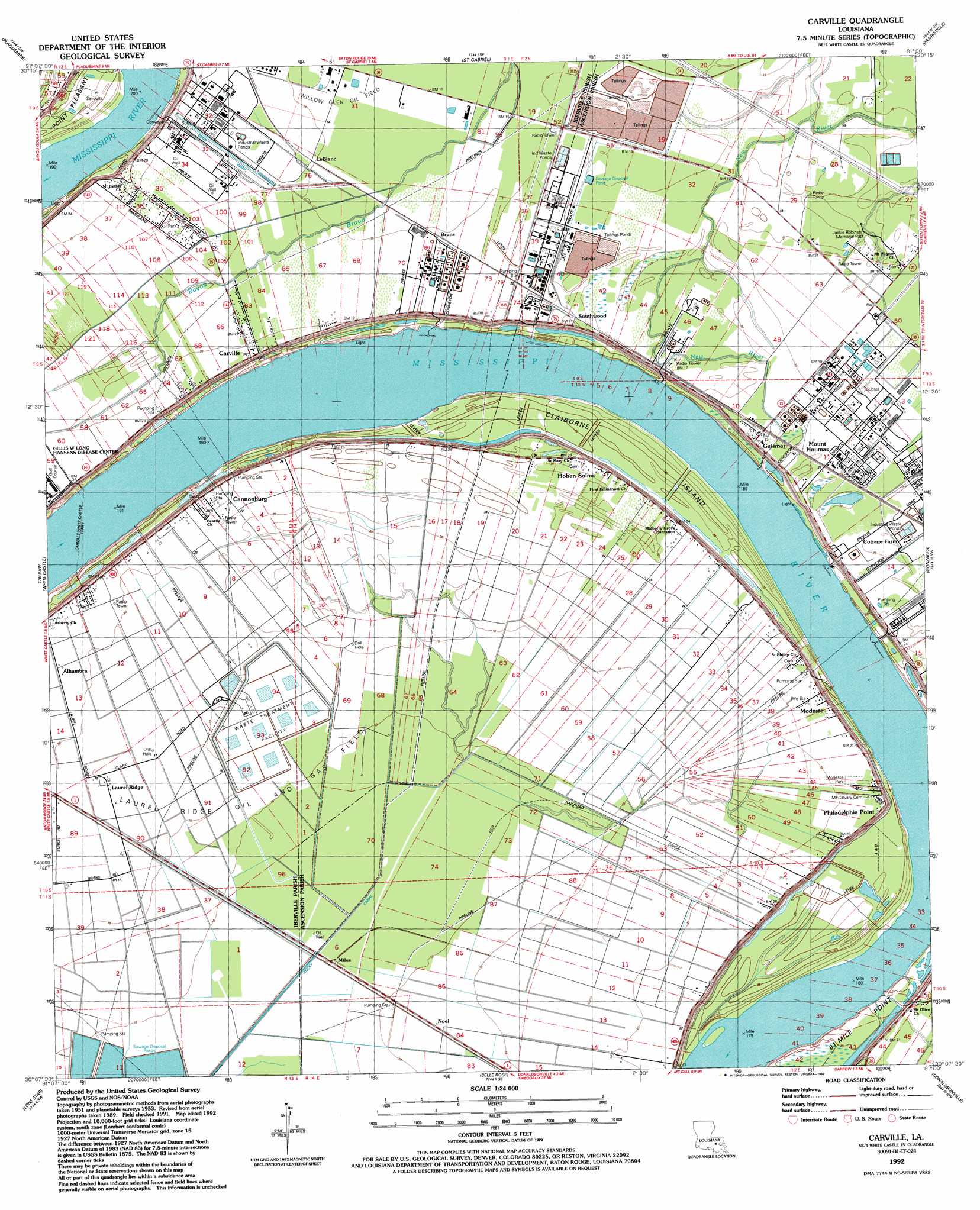
Carville Topo Map Louisiana
To zoom in, hover over the map of Carville
USGS Topo Quad 30091b1 - 1:24,000 scale
| Topo Map Name: | Carville |
| USGS Topo Quad ID: | 30091b1 |
| Print Size: | ca. 21 1/4" wide x 27" high |
| Southeast Coordinates: | 30.125° N latitude / 91° W longitude |
| Map Center Coordinates: | 30.1875° N latitude / 91.0625° W longitude |
| U.S. State: | LA |
| Filename: | o30091b1.jpg |
| Download Map JPG Image: | Carville topo map 1:24,000 scale |
| Map Type: | Topographic |
| Topo Series: | 7.5´ |
| Map Scale: | 1:24,000 |
| Source of Map Images: | United States Geological Survey (USGS) |
| Alternate Map Versions: |
Carville LA 1953, updated 1963 Download PDF Buy paper map Carville LA 1974, updated 1975 Download PDF Buy paper map Carville LA 1974, updated 1986 Download PDF Buy paper map Carville LA 1992, updated 1992 Download PDF Buy paper map Carville LA 1999, updated 2000 Download PDF Buy paper map Carville LA 2012 Download PDF Buy paper map Carville LA 2015 Download PDF Buy paper map |
1:24,000 Topo Quads surrounding Carville
Lobdell |
Baton Rouge West |
Baton Rouge East |
Denham Springs |
Walker |
Addis |
Plaquemine |
Saint Gabriel |
Prairieville |
French Settlement |
Bayou Sorrel |
White Castle |
Carville |
Gonzales |
Sorrento |
Pigeon |
Lone Star |
Belle Rose |
Donaldsonville |
Convent |
Centerville Ne |
Pierre Part |
Napoleonville |
Madewood |
Lagan |
> Back to 30091a1 at 1:100,000 scale
> Back to 30090a1 at 1:250,000 scale
> Back to U.S. Topo Maps home
Carville topo map: Gazetteer
Carville: Airports
Union Texas Petroleum Heliport elevation 4m 13′Carville: Canals
Rocky Canal elevation 2m 6′Carville: Crossings
Carville-White Castle Ferry elevation 3m 9′Carville: Islands
Claiborne Island elevation 8m 26′Carville: Levees
Philadelphia Point Revetment elevation 2m 6′Carville: Oilfields
Laurel Ridge Oil and Gas Field elevation 5m 16′Carville: Parks
Jackie Robinson Memorial Park elevation 5m 16′Modeste Park elevation 6m 19′
Carville: Populated Places
Alhambra elevation 6m 19′Bruns elevation 4m 13′
Cannonburg elevation 7m 22′
Carville elevation 6m 19′
Dreyfus (historical) elevation 6m 19′
Geismar elevation 7m 22′
Hohen Solms elevation 13m 42′
Laurel Ridge elevation 6m 19′
LeBlanc elevation 5m 16′
Louisville (historical) elevation 5m 16′
Miles elevation 2m 6′
Modeste elevation 7m 22′
Mount Houmas elevation 7m 22′
Noel elevation 4m 13′
Philadelphia Point elevation 6m 19′
Southwood elevation 6m 19′
Carville: Post Offices
Carville Post Office elevation 7m 22′Geismar Post Office elevation 5m 16′
Modeste Post Office elevation 7m 22′
Carville digital topo map on disk
Buy this Carville topo map showing relief, roads, GPS coordinates and other geographical features, as a high-resolution digital map file on DVD: