White Castle Topo Map Louisiana
To zoom in, hover over the map of White Castle
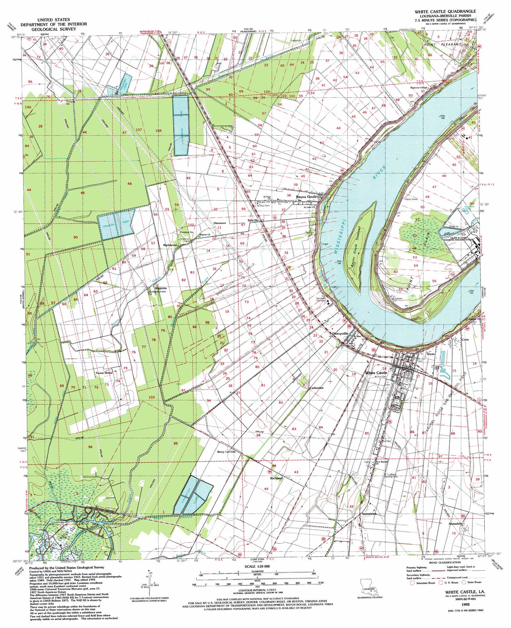
USGS Topo Quad 30091b2 - 1:24,000 scale
| Topo Map Name: | White Castle |
| USGS Topo Quad ID: | 30091b2 |
| Print Size: | ca. 21 1/4" wide x 27" high |
| Southeast Coordinates: | 30.125° N latitude / 91.125° W longitude |
| Map Center Coordinates: | 30.1875° N latitude / 91.1875° W longitude |
| U.S. State: | LA |
| Filename: | o30091b2.jpg |
| Download Map JPG Image: | White Castle topo map 1:24,000 scale |
| Map Type: | Topographic |
| Topo Series: | 7.5´ |
| Map Scale: | 1:24,000 |
| Source of Map Images: | United States Geological Survey (USGS) |
| Alternate Map Versions: |
White Castle LA 1953, updated 1955 Download PDF Buy paper map White Castle LA 1953, updated 1964 Download PDF Buy paper map White Castle LA 1974, updated 1975 Download PDF Buy paper map White Castle LA 1974, updated 1991 Download PDF Buy paper map White Castle LA 1992, updated 1992 Download PDF Buy paper map White Castle LA 2012 Download PDF Buy paper map White Castle LA 2015 Download PDF Buy paper map |
1:24,000 Topo Quads surrounding White Castle
Grosse Tete |
Lobdell |
Baton Rouge West |
Baton Rouge East |
Denham Springs |
Grosse Tete Sw |
Addis |
Plaquemine |
Saint Gabriel |
Prairieville |
Grand River |
Bayou Sorrel |
White Castle |
Carville |
Gonzales |
Lake Chicot |
Pigeon |
Lone Star |
Belle Rose |
Donaldsonville |
Centerville Nw |
Centerville Ne |
Pierre Part |
Napoleonville |
Madewood |
> Back to 30091a1 at 1:100,000 scale
> Back to 30090a1 at 1:250,000 scale
> Back to U.S. Topo Maps home
White Castle topo map: Gazetteer
White Castle: Airports
Cora Texas Landing Strip elevation 3m 9′Damien Heliport elevation 6m 19′
R T Le Blanc Landing Strip elevation 5m 16′
White Castle: Bends
Bayou Goula Bend elevation 9m 29′White Castle: Canals
George Ditch elevation 2m 6′White Castle: Capes
Point Clair elevation 6m 19′White Castle: Islands
Bayou Goula Towhead elevation 8m 26′White Castle: Levees
White Castle Revetment elevation 10m 32′White Castle: Oilfields
Dorcyville Oil Field elevation 4m 13′Laurel Ridge Gas and Oil Field elevation 6m 19′
White Castle Oil Field elevation 1m 3′
White Castle: Parks
Burton Park elevation 6m 19′White Castle: Populated Places
Annadale elevation 4m 13′Augusta elevation 4m 13′
Bayou Goula elevation 6m 19′
Blythwood elevation 4m 13′
Bruly La Croix elevation 3m 9′
Catherine elevation 6m 19′
Cedar Grove (historical) elevation 6m 19′
Cora elevation 6m 19′
Dorcyville elevation 7m 22′
Glenmore elevation 5m 16′
Haaseville elevation 7m 22′
Richland elevation 4m 13′
Samstown elevation 4m 13′
Soniat elevation 7m 22′
Tally Ho elevation 4m 13′
Texas elevation 6m 19′
White Castle elevation 7m 22′
White Castle: Post Offices
Bayou Goula Post Office elevation 6m 19′White Castle: Streams
Bayou Danials elevation 1m 3′Bayou Goula elevation 2m 6′
Bayou la Butte elevation 2m 6′
White Castle digital topo map on disk
Buy this White Castle topo map showing relief, roads, GPS coordinates and other geographical features, as a high-resolution digital map file on DVD: