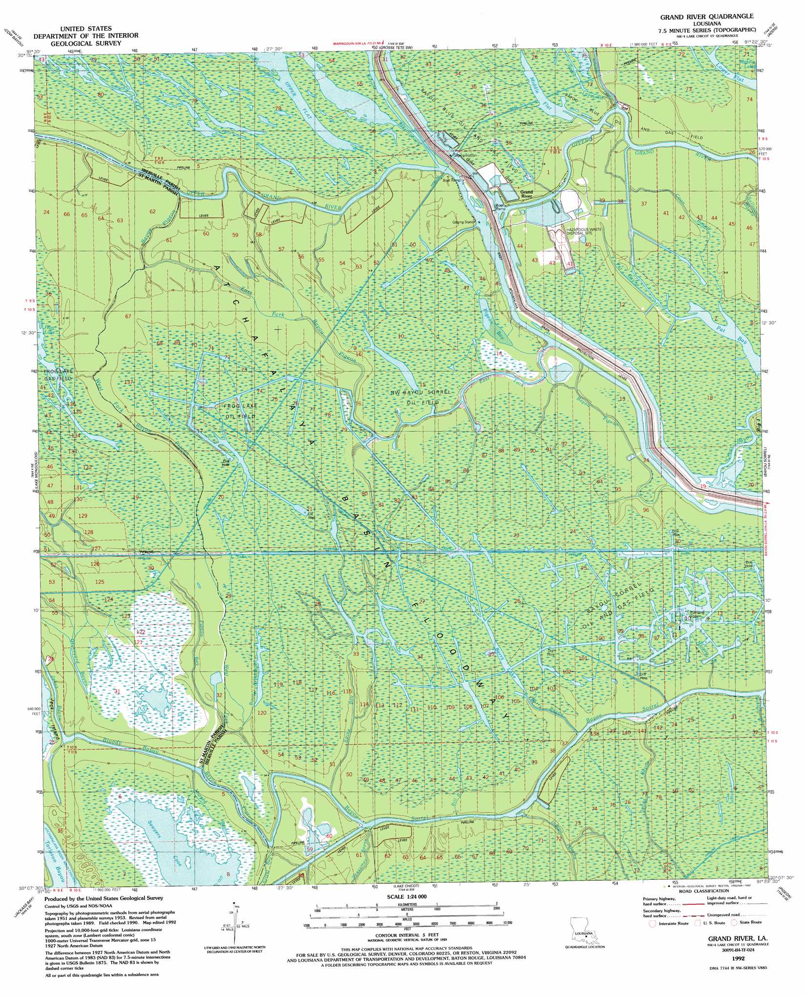
Grand River Topo Map Louisiana
To zoom in, hover over the map of Grand River
USGS Topo Quad 30091b4 - 1:24,000 scale
| Topo Map Name: | Grand River |
| USGS Topo Quad ID: | 30091b4 |
| Print Size: | ca. 21 1/4" wide x 27" high |
| Southeast Coordinates: | 30.125° N latitude / 91.375° W longitude |
| Map Center Coordinates: | 30.1875° N latitude / 91.4375° W longitude |
| U.S. State: | LA |
| Filename: | o30091b4.jpg |
| Download Map JPG Image: | Grand River topo map 1:24,000 scale |
| Map Type: | Topographic |
| Topo Series: | 7.5´ |
| Map Scale: | 1:24,000 |
| Source of Map Images: | United States Geological Survey (USGS) |
| Alternate Map Versions: |
Pigeon Bay LA 1953, updated 1954 Download PDF Buy paper map Pigeon Bay LA 1953, updated 1961 Download PDF Buy paper map Grand River LA 1969, updated 1971 Download PDF Buy paper map Grand River LA 1969, updated 1973 Download PDF Buy paper map Grand River LA 1969, updated 1980 Download PDF Buy paper map Grand River LA 1992, updated 1992 Download PDF Buy paper map Grand River LA 2012 Download PDF Buy paper map Grand River LA 2015 Download PDF Buy paper map |
1:24,000 Topo Quads surrounding Grand River
Maringouin Nw |
Maringouin |
Grosse Tete |
Lobdell |
Baton Rouge West |
Butte La Rose |
Cow Bayou |
Grosse Tete Sw |
Addis |
Plaquemine |
Catahoula |
Lake Mongoulois |
Grand River |
Bayou Sorrel |
White Castle |
Loreauville |
Jackass Bay |
Lake Chicot |
Pigeon |
Lone Star |
Jeanerette |
Charenton |
Centerville Nw |
Centerville Ne |
Pierre Part |
> Back to 30091a1 at 1:100,000 scale
> Back to 30090a1 at 1:250,000 scale
> Back to U.S. Topo Maps home
Grand River topo map: Gazetteer
Grand River: Bays
Pigeon Bay elevation 2m 6′Sawyers Cove elevation 1m 3′
Grand River: Guts
Bayou Simpson elevation 1m 3′Pigeon Bay elevation 4m 13′
Spike Bay elevation 4m 13′
Grand River: Lakes
Berry Lake elevation 1m 3′Lower Flat elevation 0m 0′
Middle Flat elevation 0m 0′
Grand River: Oilfields
Bayou Sorrel Oil and Gas Field elevation 1m 3′Frog Lake Oil Field elevation 3m 9′
Northwest Bayou Sorrel Oil Field elevation 2m 6′
Grand River: Populated Places
Grand River elevation 1m 3′Grand River: Streams
Bayou Lafayette elevation 0m 0′Bayou Maringouin elevation 3m 9′
Bayou Pigeon elevation 4m 13′
Berry Bayou elevation 1m 3′
Bill Bayou elevation 1m 3′
Bill Bayou elevation 1m 3′
Bloody Bayou elevation 3m 9′
Burns Bayou elevation 3m 9′
Caney Bayou elevation 2m 6′
Coon Bayou elevation 1m 3′
East Fork Bayou Pigeon elevation 1m 3′
Jakes Bayou elevation 1m 3′
Jones Bayou elevation 2m 6′
Moody Bayou elevation 1m 3′
Pat Bayou elevation 0m 0′
Sorrel Bay elevation 4m 13′
Sullivan Bayou elevation 2m 6′
West Fork Bayou Pigeon elevation 1m 3′
Grand River digital topo map on disk
Buy this Grand River topo map showing relief, roads, GPS coordinates and other geographical features, as a high-resolution digital map file on DVD: