Lake Mongoulois Topo Map Louisiana
To zoom in, hover over the map of Lake Mongoulois
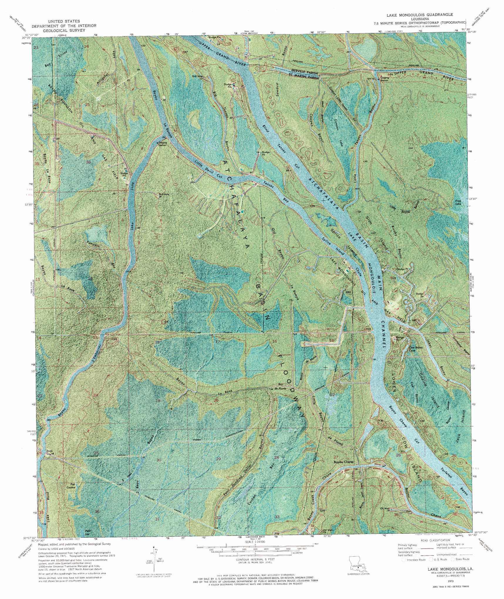
USGS Topo Quad 30091b5 - 1:24,000 scale
| Topo Map Name: | Lake Mongoulois |
| USGS Topo Quad ID: | 30091b5 |
| Print Size: | ca. 21 1/4" wide x 27" high |
| Southeast Coordinates: | 30.125° N latitude / 91.5° W longitude |
| Map Center Coordinates: | 30.1875° N latitude / 91.5625° W longitude |
| U.S. State: | LA |
| Filename: | p30091b5.jpg |
| Download Map JPG Image: | Lake Mongoulois topo map 1:24,000 scale |
| Map Type: | Orthophoto |
| Topo Series: | 7.5´ |
| Map Scale: | 1:24,000 |
| Source of Map Images: | United States Geological Survey (USGS) |
| Alternate Map Versions: |
Lake Mongoulois LA 1973, updated 1976 Download PDF Buy paper map Lake Mongoulois LA 2012 Download PDF Buy paper map Lake Mongoulois LA 2015 Download PDF Buy paper map |
1:24,000 Topo Quads surrounding Lake Mongoulois
Portage |
Maringouin Nw |
Maringouin |
Grosse Tete |
Lobdell |
Cecilia |
Butte La Rose |
Cow Bayou |
Grosse Tete Sw |
Addis |
Parks |
Catahoula |
Lake Mongoulois |
Grand River |
Bayou Sorrel |
New Iberia North |
Loreauville |
Jackass Bay |
Lake Chicot |
Pigeon |
New Iberia South |
Jeanerette |
Charenton |
Centerville Nw |
Centerville Ne |
> Back to 30091a1 at 1:100,000 scale
> Back to 30090a1 at 1:250,000 scale
> Back to U.S. Topo Maps home
Lake Mongoulois topo map: Gazetteer
Lake Mongoulois: Bays
Bay De Plomb elevation 2m 6′Cow Bayou Cove elevation 5m 16′
Tensas Bay elevation 1m 3′
Lake Mongoulois: Canals
Atchafalaya Basin Main Channel elevation 1m 3′Bayou Chene Cut elevation 1m 3′
Blind Tensas Cut elevation 1m 3′
Little Devil Cut elevation 1m 3′
Lake Mongoulois: Flats
Atchafalaya Basin Floodway elevation 3m 9′Lake Mongoulois: Guts
Logan Chute elevation 6m 19′Lake Mongoulois: Islands
Cow Island elevation 7m 22′Cozine Island elevation 4m 13′
Jack Island elevation 4m 13′
Slim Island elevation 7m 22′
Splice Island elevation 5m 16′
Lake Mongoulois: Lakes
Fish Coulee elevation 2m 6′Frog Lake elevation 2m 6′
Lake Mongoulois elevation 1m 3′
Long Lake elevation 1m 3′
Petit Lac elevation 1m 3′
Poison Lake elevation 4m 13′
Lake Mongoulois: Oilfields
Bayou Bouillon Oil and Gas Field elevation 4m 13′Bayou Chene Oil Field elevation 4m 13′
Bayou Crook Chene Oil Field elevation 3m 9′
Frog Lake Gas Field elevation 3m 9′
Lake Mongoulois Oil and Gas Field elevation 5m 16′
Lake Mongoulois: Populated Places
Bayou Chene elevation 5m 16′Lake Mongoulois: Streams
Alligator Lake elevation 4m 13′Bayou De Plomb elevation 4m 13′
Bayou L' Embarras elevation 2m 6′
Bayou La Rompe elevation 1m 3′
Bayou La Rose elevation 4m 13′
Bayou Leon elevation 1m 3′
Beau Bayou elevation 1m 3′
Big Tensas Bayou elevation 5m 16′
Cow Bayou elevation 4m 13′
Cowpen Bayou elevation 5m 16′
Cowpen Little Tensas elevation 1m 3′
Cozine Bayou elevation 4m 13′
Graveyard Bayou elevation 4m 13′
Graveyard Bayou elevation 2m 6′
Little Bayou Brison elevation 2m 6′
Little Bayou De Plomb elevation 3m 9′
Little Tensas Bayou elevation 3m 9′
Meat Bayou elevation 4m 13′
Old Bayou La Rompe elevation 4m 13′
Pumpkin Bay elevation 5m 16′
Ricaby Bayou elevation 5m 16′
Splice Island Chute elevation 1m 3′
Lake Mongoulois: Swamps
Bay Sirius elevation 4m 13′Cochon Bay elevation 1m 3′
Cowpen Lake elevation 3m 9′
Lake Mongoulois digital topo map on disk
Buy this Lake Mongoulois topo map showing relief, roads, GPS coordinates and other geographical features, as a high-resolution digital map file on DVD: