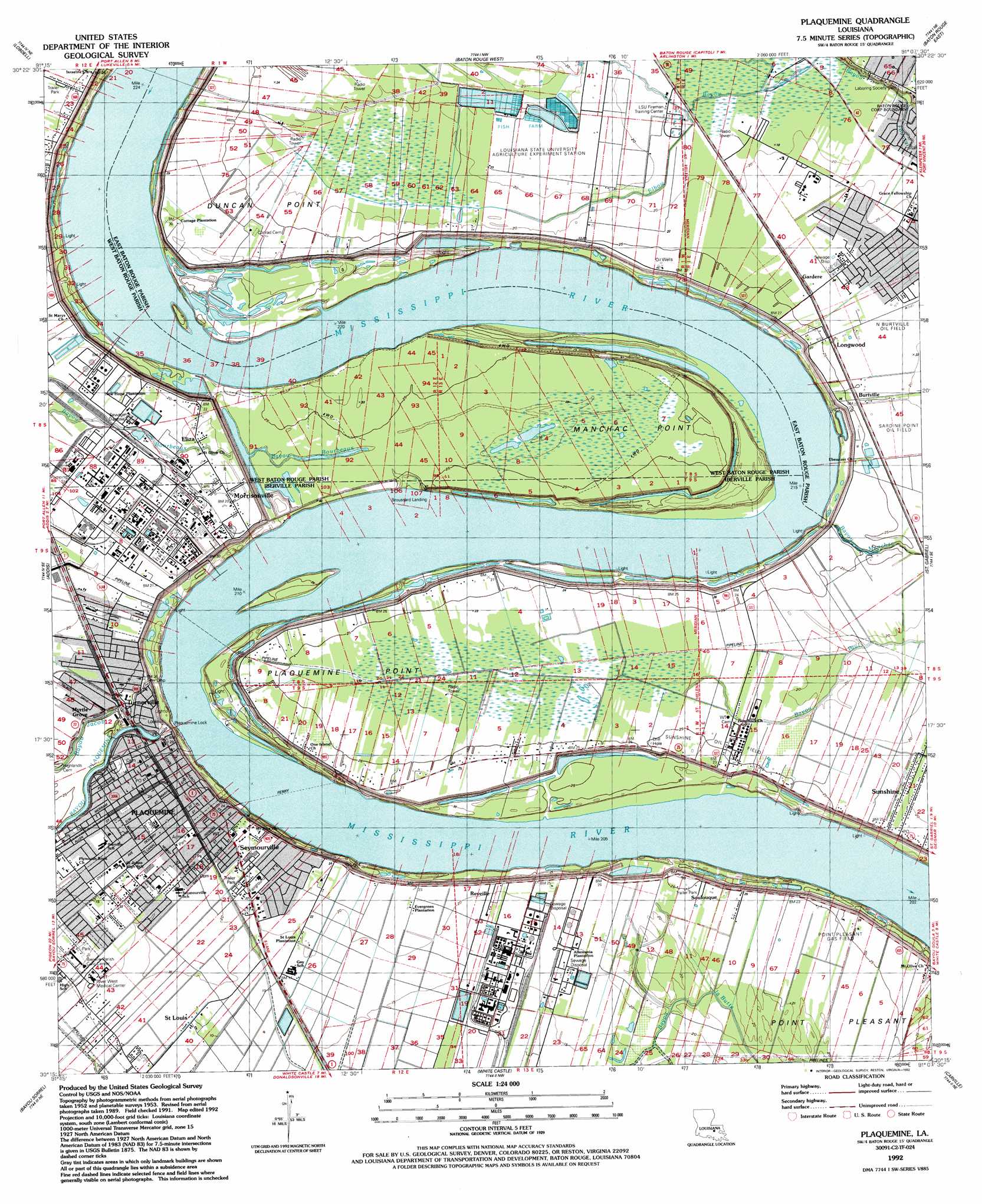
Plaquemine Topo Map Louisiana
To zoom in, hover over the map of Plaquemine
USGS Topo Quad 30091c2 - 1:24,000 scale
| Topo Map Name: | Plaquemine |
| USGS Topo Quad ID: | 30091c2 |
| Print Size: | ca. 21 1/4" wide x 27" high |
| Southeast Coordinates: | 30.25° N latitude / 91.125° W longitude |
| Map Center Coordinates: | 30.3125° N latitude / 91.1875° W longitude |
| U.S. State: | LA |
| Filename: | o30091c2.jpg |
| Download Map JPG Image: | Plaquemine topo map 1:24,000 scale |
| Map Type: | Topographic |
| Topo Series: | 7.5´ |
| Map Scale: | 1:24,000 |
| Source of Map Images: | United States Geological Survey (USGS) |
| Alternate Map Versions: |
Plaquemine LA 1953, updated 1954 Download PDF Buy paper map Plaquemine LA 1963, updated 1964 Download PDF Buy paper map Plaquemine LA 1963, updated 1968 Download PDF Buy paper map Plaquemine LA 1963, updated 1972 Download PDF Buy paper map Plaquemine LA 1963, updated 1981 Download PDF Buy paper map Plaquemine LA 1963, updated 1989 Download PDF Buy paper map Plaquemine LA 1992, updated 1992 Download PDF Buy paper map Plaquemine LA 1992, updated 1992 Download PDF Buy paper map Plaquemine LA 1998, updated 2003 Download PDF Buy paper map Plaquemine LA 2012 Download PDF Buy paper map Plaquemine LA 2015 Download PDF Buy paper map |
1:24,000 Topo Quads surrounding Plaquemine
Erwinville |
Walls |
Scotlandville |
Comite |
Watson |
Grosse Tete |
Lobdell |
Baton Rouge West |
Baton Rouge East |
Denham Springs |
Grosse Tete Sw |
Addis |
Plaquemine |
Saint Gabriel |
Prairieville |
Grand River |
Bayou Sorrel |
White Castle |
Carville |
Gonzales |
Lake Chicot |
Pigeon |
Lone Star |
Belle Rose |
Donaldsonville |
> Back to 30091a1 at 1:100,000 scale
> Back to 30090a1 at 1:250,000 scale
> Back to U.S. Topo Maps home
Plaquemine topo map: Gazetteer
Plaquemine: Airports
River West Medical Center Heliport elevation 6m 19′Plaquemine: Bends
Manchac Bend elevation 4m 13′Missouri Bend elevation 4m 13′
Plaquemine Bend elevation 3m 9′
Plaquemine: Capes
Duncan Point elevation 7m 22′Manchac Point elevation 7m 22′
Plaquemine Point elevation 6m 19′
Point Pleasant elevation 6m 19′
Plaquemine: Dams
Plaquemine Lock elevation 8m 26′Plaquemine: Levees
Manchac Revetment elevation 7m 22′Missouri Bend Revetment elevation 4m 13′
Plaquemine Bend Revetment elevation 3m 9′
Plaquemine: Oilfields
Manchac Point Oil Field elevation 7m 22′Manchac Point Oil Field elevation 10m 32′
Morrisonville Oil Field elevation 7m 22′
North Burtville Oil Field elevation 7m 22′
Point Pleasant Gas Field elevation 7m 22′
Sunshine Oil Field elevation 7m 22′
Plaquemine: Parks
Plaquemine Historic District elevation 7m 22′Plaquemine Lock State Historic Site elevation 10m 32′
Plaquemine: Populated Places
Allemania elevation 6m 19′Bayou Fountain elevation 5m 16′
Ben Hut (historical) elevation 7m 22′
Broussard Landing elevation 3m 9′
Burtville elevation 7m 22′
Eliza elevation 6m 19′
Evangeline Hermitage Estates elevation 6m 19′
Evergreen Plantation elevation 7m 22′
Gardere elevation 7m 22′
Gardere Place elevation 6m 19′
Highland Creek elevation 5m 16′
Indian Park elevation 6m 19′
Longwood elevation 8m 26′
Morrisonville elevation 6m 19′
Myrtle Grove elevation 7m 22′
Plaquemine elevation 7m 22′
Reveille elevation 6m 19′
Riverland elevation 7m 22′
Sable Chase elevation 7m 22′
Saint Louis elevation 5m 16′
Saint Louis Plantation elevation 5m 16′
Sardine Point Settlement (historical) elevation 4m 13′
Seymourville elevation 7m 22′
Soulouque elevation 8m 26′
South Highland elevation 6m 19′
Starling (historical) elevation 7m 22′
Sunshine elevation 7m 22′
Turnerville elevation 8m 26′
University Shadows elevation 5m 16′
Plaquemine: Post Offices
Plaquemine Post Office elevation 8m 26′Sunshine Post Office (historical) elevation 7m 22′
Plaquemine digital topo map on disk
Buy this Plaquemine topo map showing relief, roads, GPS coordinates and other geographical features, as a high-resolution digital map file on DVD: