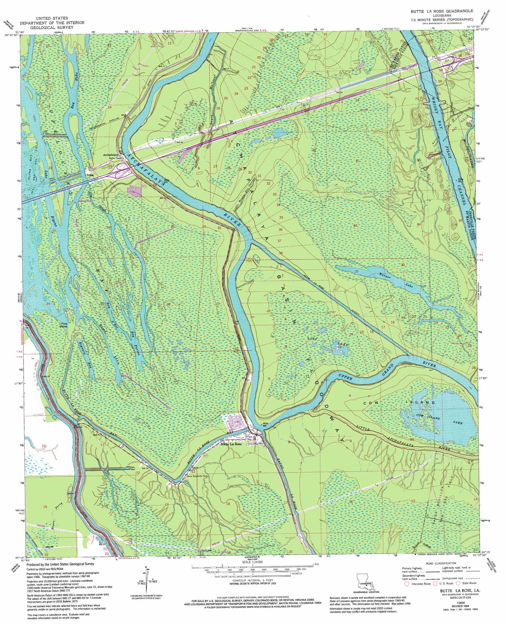
Butte La Rose Topo Map Louisiana
To zoom in, hover over the map of Butte La Rose
USGS Topo Quad 30091c6 - 1:24,000 scale
| Topo Map Name: | Butte La Rose |
| USGS Topo Quad ID: | 30091c6 |
| Print Size: | ca. 21 1/4" wide x 27" high |
| Southeast Coordinates: | 30.25° N latitude / 91.625° W longitude |
| Map Center Coordinates: | 30.3125° N latitude / 91.6875° W longitude |
| U.S. State: | LA |
| Filename: | o30091c6.jpg |
| Download Map JPG Image: | Butte La Rose topo map 1:24,000 scale |
| Map Type: | Topographic |
| Topo Series: | 7.5´ |
| Map Scale: | 1:24,000 |
| Source of Map Images: | United States Geological Survey (USGS) |
| Alternate Map Versions: |
Butte La Rose LA 1968, updated 1968 Download PDF Buy paper map Butte La Rose LA 1968, updated 1970 Download PDF Buy paper map Butte La Rose LA 1968, updated 1988 Download PDF Buy paper map Butte La Rose LA 1968, updated 1998 Download PDF Buy paper map Butte La Rose LA 1999, updated 2000 Download PDF Buy paper map Butte La Rose LA 2012 Download PDF Buy paper map Butte La Rose LA 2015 Download PDF Buy paper map |
1:24,000 Topo Quads surrounding Butte La Rose
Port Barre |
Krotz Springs |
Lottie |
Fordoche |
Erwinville |
Arnaudville |
Portage |
Maringouin Nw |
Maringouin |
Grosse Tete |
Breaux Bridge |
Cecilia |
Butte La Rose |
Cow Bayou |
Grosse Tete Sw |
Broussard |
Parks |
Catahoula |
Lake Mongoulois |
Grand River |
Youngsville |
New Iberia North |
Loreauville |
Jackass Bay |
Lake Chicot |
> Back to 30091a1 at 1:100,000 scale
> Back to 30090a1 at 1:250,000 scale
> Back to U.S. Topo Maps home
Butte La Rose topo map: Gazetteer
Butte La Rose: Bays
Bay A'Bot elevation 3m 9′Bay Farine elevation 3m 9′
Bay Haha elevation 3m 9′
Begnard Bay elevation 3m 9′
Butte La Rose: Canals
Bayou Berard Canal elevation 2m 6′Butte La Rose Cutoff elevation 5m 16′
Butte La Rose: Capes
Five Point elevation 4m 13′Butte La Rose: Crossings
Interchange 121 elevation 7m 22′Interchange 127 elevation 6m 19′
Butte La Rose: Islands
Cow Island elevation 4m 13′Butte La Rose: Lakes
Cow Island Lake elevation 4m 13′Lake Bigeux elevation 3m 9′
Lake Pelba elevation 3m 9′
Lost Lake elevation 4m 13′
Warner Lake elevation 2m 6′
Butte La Rose: Parks
Davis Roadside Park elevation 5m 16′Butte La Rose: Populated Places
Atchafalaya elevation 8m 26′Butte La Rose elevation 7m 22′
Crusel (historical) elevation 5m 16′
Pelba elevation 5m 16′
Butte La Rose: Streams
Atchafalaya River elevation 1m 3′Bayou La Rose elevation 2m 6′
Bayou Loin elevation 3m 9′
Bayou Malboeuf elevation 7m 22′
Bayou Perry elevation 3m 9′
Butte La Rose Bay elevation 3m 9′
Gin Slough elevation 3m 9′
Little Bayou Des Ourses elevation 1m 3′
Butte La Rose: Swamps
Opelousas Bay elevation 4m 13′Butte La Rose digital topo map on disk
Buy this Butte La Rose topo map showing relief, roads, GPS coordinates and other geographical features, as a high-resolution digital map file on DVD: