Baton Rouge West Topo Map Louisiana
To zoom in, hover over the map of Baton Rouge West
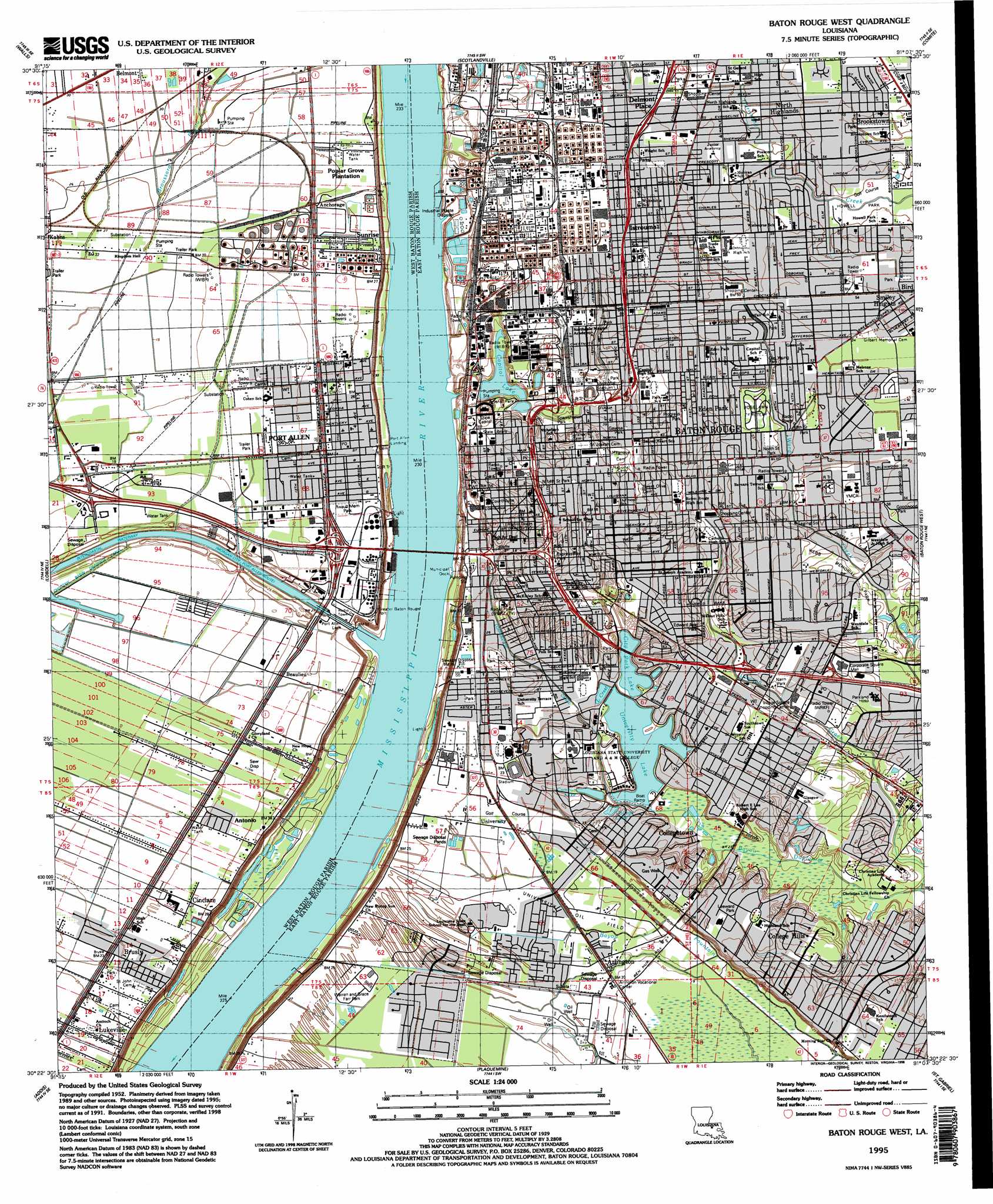
USGS Topo Quad 30091d2 - 1:24,000 scale
| Topo Map Name: | Baton Rouge West |
| USGS Topo Quad ID: | 30091d2 |
| Print Size: | ca. 21 1/4" wide x 27" high |
| Southeast Coordinates: | 30.375° N latitude / 91.125° W longitude |
| Map Center Coordinates: | 30.4375° N latitude / 91.1875° W longitude |
| U.S. State: | LA |
| Filename: | o30091d2.jpg |
| Download Map JPG Image: | Baton Rouge West topo map 1:24,000 scale |
| Map Type: | Topographic |
| Topo Series: | 7.5´ |
| Map Scale: | 1:24,000 |
| Source of Map Images: | United States Geological Survey (USGS) |
| Alternate Map Versions: |
Baton Rouge West LA 1953, updated 1954 Download PDF Buy paper map Baton Rouge West LA 1963, updated 1964 Download PDF Buy paper map Baton Rouge West LA 1963, updated 1971 Download PDF Buy paper map Baton Rouge West LA 1963, updated 1972 Download PDF Buy paper map Baton Rouge West LA 1963, updated 1981 Download PDF Buy paper map Baton Rouge West LA 1963, updated 1989 Download PDF Buy paper map Baton Rouge West LA 1992, updated 1992 Download PDF Buy paper map Baton Rouge West LA 1992, updated 1992 Download PDF Buy paper map Baton Rouge West LA 1995, updated 1998 Download PDF Buy paper map Baton Rouge West LA 2012 Download PDF Buy paper map Baton Rouge West LA 2015 Download PDF Buy paper map |
1:24,000 Topo Quads surrounding Baton Rouge West
New Roads |
Port Hudson |
Zachary |
Fred |
Pride |
Erwinville |
Walls |
Scotlandville |
Comite |
Watson |
Grosse Tete |
Lobdell |
Baton Rouge West |
Baton Rouge East |
Denham Springs |
Grosse Tete Sw |
Addis |
Plaquemine |
Saint Gabriel |
Prairieville |
Grand River |
Bayou Sorrel |
White Castle |
Carville |
Gonzales |
> Back to 30091a1 at 1:100,000 scale
> Back to 30090a1 at 1:250,000 scale
> Back to U.S. Topo Maps home
Baton Rouge West topo map: Gazetteer
Baton Rouge West: Airports
Baton Rouge General Hospital Heliport elevation 15m 49′La Dotd Headquarters Heliport elevation 15m 49′
Louisiana State Police Headquarters Heliport elevation 15m 49′
Baton Rouge West: Canals
Corporation Canal elevation 7m 22′Baton Rouge West: Cliffs
Istrouma Bluff elevation 9m 29′Baton Rouge West: Crossings
Interchange 151 elevation 5m 16′Interchange 153 elevation 8m 26′
Interchange 155 elevation 9m 29′
Interchange 156A elevation 15m 49′
Interchange 156B elevation 15m 49′
Interchange 157A elevation 10m 32′
Interchange 157B elevation 8m 26′
Interchange 158 elevation 10m 32′
Interchange 1A elevation 14m 45′
Interchange 1C elevation 16m 52′
Interchange 1D elevation 12m 39′
Interchange 1E elevation 12m 39′
Interchange 3A elevation 18m 59′
Interchange 4A elevation 18m 59′
Interchange 4B elevation 17m 55′
Baton Rouge West: Dams
Capitol Lake Dam elevation 9m 29′Port Allen Lock elevation 9m 29′
University Lake Dam elevation 6m 19′
Baton Rouge West: Harbors
Greater Baton Rouge Port elevation 9m 29′Baton Rouge West: Lakes
Campus Lake elevation 8m 26′Capitol Lake elevation 9m 29′
City Park Lake elevation 7m 22′
College Lake elevation 7m 22′
Lake Crest elevation 6m 19′
University Lake elevation 6m 19′
Baton Rouge West: Levees
Arlington Revetment elevation 4m 13′Baton Rouge West: Oilfields
Cinclare Gas Field elevation 7m 22′University Oil Field elevation 6m 19′
Baton Rouge West: Parks
40th Street Park elevation 15m 49′Alex Box Stadium elevation 7m 22′
Arsenal Park elevation 12m 39′
Beauregard Town Historic District elevation 11m 36′
Belfair Park elevation 17m 55′
Bernie Moore Track Stadium elevation 7m 22′
Bird Station Park elevation 16m 52′
Bird Station Park elevation 16m 52′
Brooks Park elevation 16m 52′
East Polk Street Park elevation 15m 49′
Edward Avenue Park elevation 11m 36′
Evangeline Park elevation 16m 52′
Expressway Park elevation 12m 39′
Fourtyeighth Street Park elevation 15m 49′
Gayosa Park elevation 12m 39′
Goodwood Playground elevation 16m 52′
Gus Young Park elevation 16m 52′
Howell Park elevation 14m 45′
Ken-Warren Playground elevation 18m 59′
Leeward Park elevation 12m 39′
Longfellow Park elevation 16m 52′
Madison Avenue Park elevation 14m 45′
Magnolia Mound Park elevation 7m 22′
Main Street Historic District elevation 16m 52′
Naivn Park elevation 11m 36′
North 14th Street Park elevation 17m 55′
North Street Park elevation 16m 52′
Progress Park elevation 16m 52′
Rivault Memorial Park elevation 7m 22′
Rivoult Memorial Park elevation 8m 26′
Roosevelt Street Park elevation 7m 22′
Roseland Terrace Historic District elevation 15m 49′
Spanish Town Historic District elevation 16m 52′
Standford Park elevation 7m 22′
Terrace Street Park elevation 13m 42′
Tiger Stadium elevation 8m 26′
Tuscarrora Street Park elevation 18m 59′
Valley Park (historical) elevation 12m 39′
Victory Park elevation 15m 49′
Warren and Grace Farr Park elevation 7m 22′
Webb Memorial Park elevation 12m 39′
Wenonah Street Park elevation 15m 49′
Baton Rouge West: Populated Places
Anchorage elevation 7m 22′Antonio elevation 6m 19′
Ardenwood elevation 17m 55′
Arlington elevation 6m 19′
Baton Rouge elevation 14m 45′
Baton Rouge Terrace elevation 17m 55′
Beaulieu elevation 6m 19′
Beauregard Town elevation 16m 52′
Belfair elevation 15m 49′
Belfort elevation 16m 52′
Belmont elevation 8m 26′
Bernard Terrace elevation 16m 52′
Bogan elevation 18m 59′
Brightside Park elevation 7m 22′
Brookstown elevation 17m 55′
Brusly Landing elevation 7m 22′
Capital Heights elevation 17m 55′
Capitol View elevation 15m 49′
Cinclare elevation 7m 22′
Cinclare Landing (historical) elevation 9m 29′
College Drive Heights elevation 17m 55′
College Hills elevation 12m 39′
College Park elevation 7m 22′
Collegetown elevation 11m 36′
Concord Estates elevation 8m 26′
Concord Park elevation 9m 29′
Dayton elevation 18m 59′
Delmont Place elevation 16m 52′
Dent Terrace elevation 13m 42′
Dougherty Place elevation 17m 55′
East Dayton elevation 15m 49′
Eastland elevation 11m 36′
Eden Park elevation 17m 55′
Fairwoods elevation 16m 52′
Floyd Place elevation 10m 32′
Frisco (historical) elevation 6m 19′
Glenmore elevation 17m 55′
Greenville elevation 17m 55′
Harwich elevation 7m 22′
Heatherstone elevation 7m 22′
Highland Gardens elevation 17m 55′
Highland Hills elevation 11m 36′
Highland Park Heights elevation 13m 42′
Highland Road Estates elevation 12m 39′
Howell Park Terrace elevation 17m 55′
Hundred Oaks elevation 16m 52′
Hyacinth Terrace elevation 12m 39′
Istrouma elevation 18m 59′
Kenilworth elevation 12m 39′
Kleinert elevation 17m 55′
Lakecrest elevation 9m 29′
Longwood Court elevation 16m 52′
Lukeville elevation 7m 22′
Lynn Place elevation 17m 55′
Mag Terrace elevation 10m 32′
Magnolia Heights elevation 12m 39′
Magnolia Ridge elevation 11m 36′
Marwede elevation 14m 45′
McGrath Heights elevation 11m 36′
Meadow Lea elevation 12m 39′
Melrose Place elevation 16m 52′
Midway Place elevation 18m 59′
Mirabeau Gardens elevation 10m 32′
Moreland elevation 15m 49′
Moss Side Place elevation 11m 36′
New Dayton elevation 17m 55′
Nicholson Estates elevation 7m 22′
North Highlands elevation 17m 55′
Northdale elevation 15m 49′
Ogden Park elevation 11m 36′
Platation Trace elevation 12m 39′
Pollard Estates elevation 12m 39′
Poplar Grove Plantation elevation 8m 26′
Port Allen elevation 8m 26′
Port Allen Landing elevation 5m 16′
Prescott Court elevation 17m 55′
Prescott Place elevation 17m 55′
Progress elevation 16m 52′
Riverbend elevation 7m 22′
Roppolo Villa elevation 16m 52′
Saint Gerald Park elevation 18m 59′
Sharlo elevation 7m 22′
Smiley Heights elevation 17m 55′
South Baton Rouge elevation 16m 52′
South Dayton elevation 15m 49′
Southdown elevation 12m 39′
Southdowns elevation 12m 39′
Stafford Place elevation 10m 32′
Standard Heights elevation 17m 55′
Stanford Place elevation 12m 39′
Steele Place elevation 17m 55′
Sunrise elevation 8m 26′
Swart elevation 16m 52′
Sweetbriar elevation 11m 36′
Tigerland Acres elevation 7m 22′
University Acres elevation 11m 36′
University Gardens elevation 8m 26′
University Hills elevation 11m 36′
University South elevation 7m 22′
University Terrace elevation 7m 22′
University View elevation 6m 19′
Villa Ashley elevation 16m 52′
Walnut Hill elevation 15m 49′
West Baton Rouge elevation 8m 26′
Westdale Heights elevation 15m 49′
Westdale Terrace elevation 16m 52′
White Plains elevation 17m 55′
Woodstone Estates elevation 11m 36′
Zee Zee Gardens elevation 8m 26′
Zeeland Place elevation 15m 49′
Baton Rouge West: Post Offices
Brusly Post Office elevation 7m 22′Istrouma Post Office (historical) elevation 18m 59′
Louise Street Branch Post Office (historical) elevation 17m 55′
Port Allen Post Office elevation 7m 22′
Roppoloville Post Office (historical) elevation 17m 55′
Baton Rouge West: Streams
Bayou Duplanier elevation 7m 22′Broussard Bayou elevation 5m 16′
Elbow Bayou elevation 4m 13′
Baton Rouge West digital topo map on disk
Buy this Baton Rouge West topo map showing relief, roads, GPS coordinates and other geographical features, as a high-resolution digital map file on DVD: