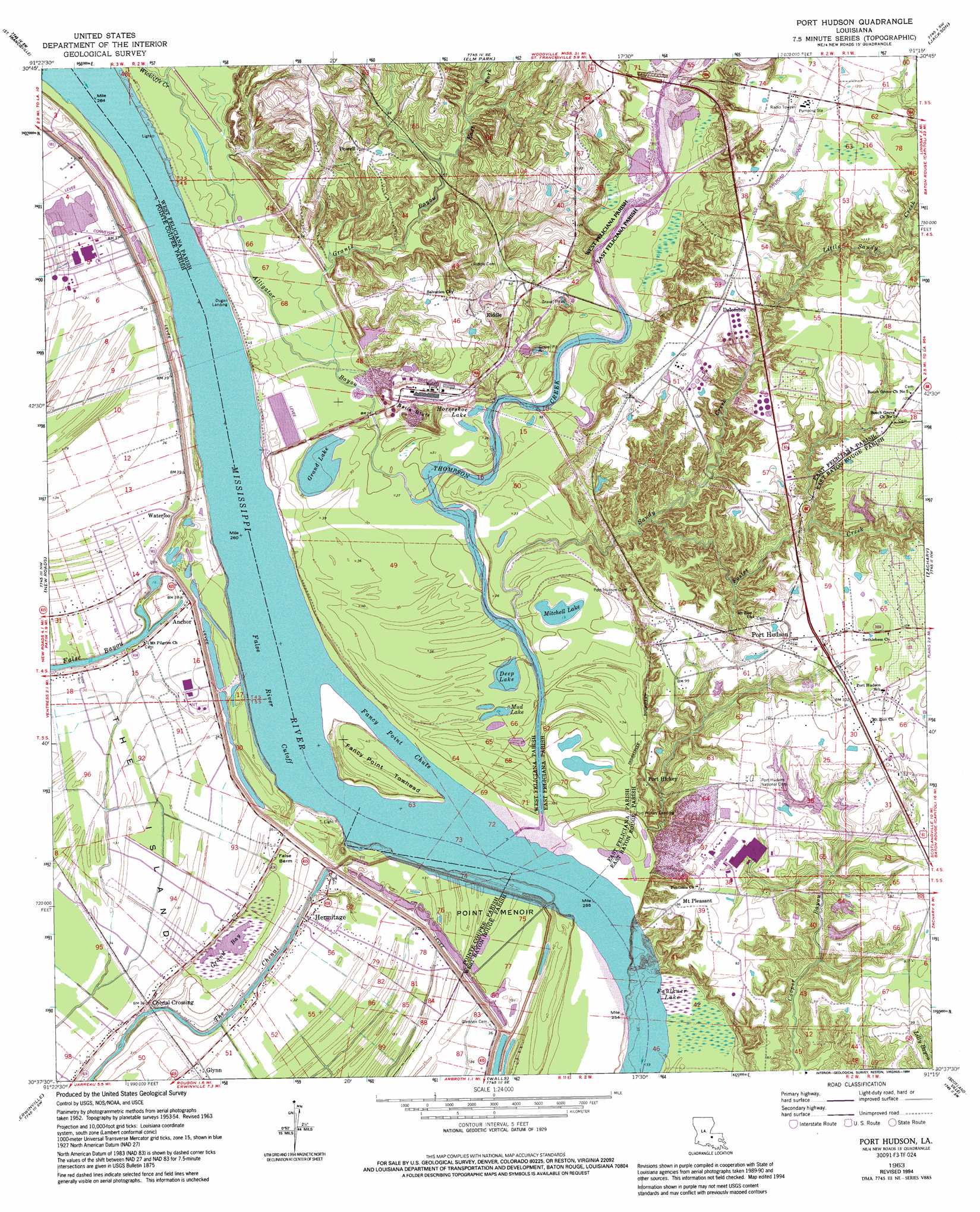
Port Hudson Topo Map Louisiana
To zoom in, hover over the map of Port Hudson
USGS Topo Quad 30091f3 - 1:24,000 scale
| Topo Map Name: | Port Hudson |
| USGS Topo Quad ID: | 30091f3 |
| Print Size: | ca. 21 1/4" wide x 27" high |
| Southeast Coordinates: | 30.625° N latitude / 91.25° W longitude |
| Map Center Coordinates: | 30.6875° N latitude / 91.3125° W longitude |
| U.S. State: | LA |
| Filename: | o30091f3.jpg |
| Download Map JPG Image: | Port Hudson topo map 1:24,000 scale |
| Map Type: | Topographic |
| Topo Series: | 7.5´ |
| Map Scale: | 1:24,000 |
| Source of Map Images: | United States Geological Survey (USGS) |
| Alternate Map Versions: |
Port Hudson LA 1954, updated 1955 Download PDF Buy paper map Port Hudson LA 1963, updated 1964 Download PDF Buy paper map Port Hudson LA 1963, updated 1968 Download PDF Buy paper map Port Hudson LA 1963, updated 1980 Download PDF Buy paper map Port Hudson LA 1963, updated 1986 Download PDF Buy paper map Port Hudson LA 1963, updated 1994 Download PDF Buy paper map Port Hudson LA 2012 Download PDF Buy paper map Port Hudson LA 2015 Download PDF Buy paper map |
1:24,000 Topo Quads surrounding Port Hudson
Tunica |
Weyanoke |
Laurel Hill |
Rogillioville |
Wilson |
Lacour |
Saint Francisville |
Elm Park |
Jackson |
Clinton |
Morganza |
New Roads |
Port Hudson |
Zachary |
Fred |
Fordoche |
Erwinville |
Walls |
Scotlandville |
Comite |
Maringouin |
Grosse Tete |
Lobdell |
Baton Rouge West |
Baton Rouge East |
> Back to 30091e1 at 1:100,000 scale
> Back to 30090a1 at 1:250,000 scale
> Back to U.S. Topo Maps home
Port Hudson topo map: Gazetteer
Port Hudson: Bends
False River Cutoff elevation 6m 19′Port Hudson: Capes
Fancy Point elevation 11m 36′Point Menoir elevation 9m 29′
Port Hudson: Cliffs
Balls Bluff elevation 9m 29′Painted Bluffs elevation 11m 36′
Port Hudson: Islands
Fancy Point Towhead elevation 11m 36′Port Hudson: Lakes
Deep Lake elevation 9m 29′Faulkner Lake elevation 12m 39′
Grand Bay elevation 5m 16′
Grand Lake elevation 9m 29′
Grass Lake elevation 10m 32′
Horseshoe Lake elevation 12m 39′
Mitchell Lake elevation 9m 29′
Mud Lake elevation 9m 29′
Port Hudson: Levees
False Berm elevation 6m 19′Grand Bay Revetment elevation 6m 19′
Port Hudson: Oilfields
Port Hudson Gas Field elevation 29m 95′Port Hudson: Parks
Port Hudson State Historic Site elevation 29m 95′Port Hudson: Populated Places
Anchor elevation 11m 36′Basel (historical) elevation 14m 45′
Bonn elevation 28m 91′
Chenal Crossing elevation 10m 32′
Delombre elevation 32m 104′
Dugan Landing elevation 7m 22′
Glynn elevation 11m 36′
Hermitage elevation 10m 32′
Mannheim (historical) elevation 18m 59′
Mount Pleasant elevation 29m 95′
Paloma (historical) elevation 25m 82′
Port Hickey elevation 27m 88′
Port Hickey Landing elevation 10m 32′
Port Hudson elevation 30m 98′
Port Jackson (historical) elevation 10m 32′
Powell elevation 33m 108′
Riddle elevation 23m 75′
Waterloo elevation 14m 45′
Port Hudson: Post Offices
Glynn Post Office elevation 10m 32′Port Hudson: Streams
Alexander Creek elevation 11m 36′Alligator Bayou elevation 9m 29′
East Fork Grants Bayou elevation 18m 59′
Fancy Point Chute elevation 6m 19′
Foster Creek elevation 9m 29′
Grants Bayou elevation 9m 29′
Little Sandy Creek elevation 22m 72′
Sandy Creek elevation 9m 29′
The Chenal elevation 9m 29′
Thompson Creek elevation 6m 19′
Wickliffe Creek elevation 11m 36′
Port Hudson digital topo map on disk
Buy this Port Hudson topo map showing relief, roads, GPS coordinates and other geographical features, as a high-resolution digital map file on DVD: