Kaplan North Topo Map Louisiana
To zoom in, hover over the map of Kaplan North
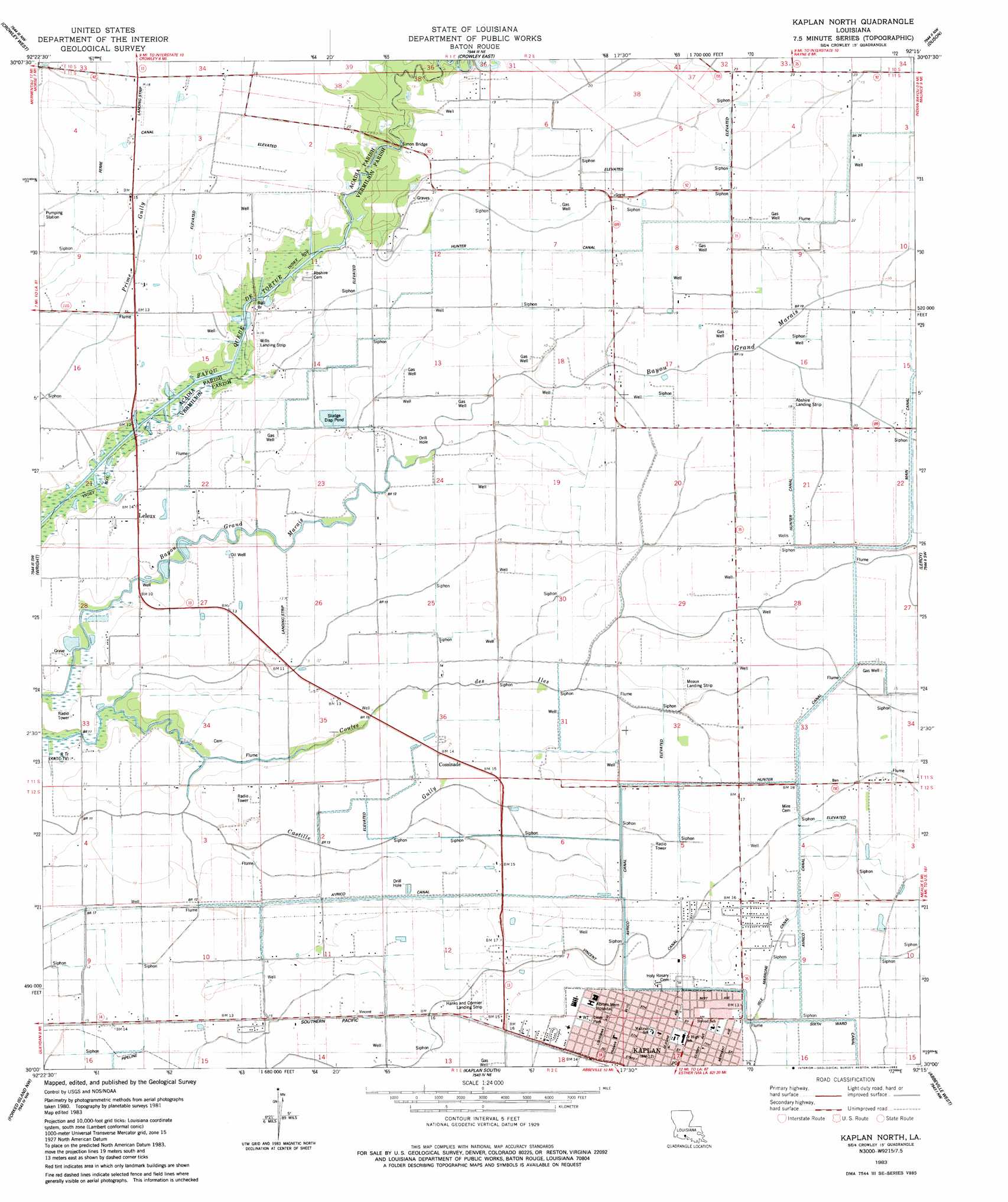
USGS Topo Quad 30092a3 - 1:24,000 scale
| Topo Map Name: | Kaplan North |
| USGS Topo Quad ID: | 30092a3 |
| Print Size: | ca. 21 1/4" wide x 27" high |
| Southeast Coordinates: | 30° N latitude / 92.25° W longitude |
| Map Center Coordinates: | 30.0625° N latitude / 92.3125° W longitude |
| U.S. State: | LA |
| Filename: | o30092a3.jpg |
| Download Map JPG Image: | Kaplan North topo map 1:24,000 scale |
| Map Type: | Topographic |
| Topo Series: | 7.5´ |
| Map Scale: | 1:24,000 |
| Source of Map Images: | United States Geological Survey (USGS) |
| Alternate Map Versions: |
Kaplan North LA 1983, updated 1983 Download PDF Buy paper map Kaplan North LA 2012 Download PDF Buy paper map Kaplan North LA 2015 Download PDF Buy paper map |
1:24,000 Topo Quads surrounding Kaplan North
Evangeline |
Iota |
Branch |
Mire |
Carencro |
Mermentau |
Crowley West |
Crowley East |
Duson |
Lafayette |
Gueydan |
Wright |
Kaplan North |
Leroy |
Milton |
Latanier Bayou |
Forked Island Nw |
Kaplan South |
Abbeville West |
Abbeville East |
Lake Le Bleu |
Jacks Point Island |
Forked Island |
Intracoastal City |
Hebert Lake |
> Back to 30092a1 at 1:100,000 scale
> Back to 30092a1 at 1:250,000 scale
> Back to U.S. Topo Maps home
Kaplan North topo map: Gazetteer
Kaplan North: Airports
Abrom Kaplan Memorial Hospital Heliport elevation 4m 13′Abshire Landing Strip elevation 5m 16′
Hanks Airport elevation 4m 13′
Meaux Landing Strip elevation 5m 16′
Wills Landing Strip elevation 3m 9′
Kaplan North: Areas
Coles Island elevation 3m 9′Kaplan North: Bridges
Simon Bridge elevation 1m 3′Kaplan North: Canals
Hunter Canal elevation 4m 13′Vincent Canal elevation 4m 13′
Kaplan North: Oilfields
Cossinade Gas Field elevation 5m 16′Kaplan Gas Field elevation 4m 13′
Lelieux Oil and Gas Field elevation 4m 13′
Kaplan North: Parks
Liner Park elevation 4m 13′Kaplan North: Populated Places
Cossinade elevation 4m 13′Leleux elevation 4m 13′
Kaplan North: Post Offices
Kaplan Post Office elevation 4m 13′Kaplan North digital topo map on disk
Buy this Kaplan North topo map showing relief, roads, GPS coordinates and other geographical features, as a high-resolution digital map file on DVD: