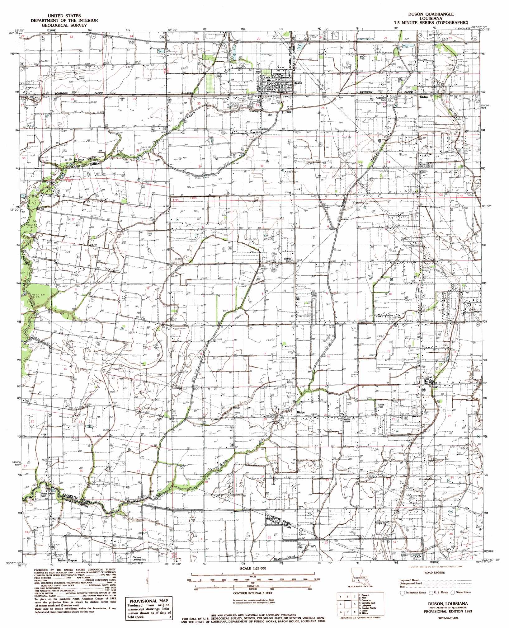
Duson Topo Map Louisiana
To zoom in, hover over the map of Duson
USGS Topo Quad 30092b2 - 1:24,000 scale
| Topo Map Name: | Duson |
| USGS Topo Quad ID: | 30092b2 |
| Print Size: | ca. 21 1/4" wide x 27" high |
| Southeast Coordinates: | 30.125° N latitude / 92.125° W longitude |
| Map Center Coordinates: | 30.1875° N latitude / 92.1875° W longitude |
| U.S. State: | LA |
| Filename: | o30092b2.jpg |
| Download Map JPG Image: | Duson topo map 1:24,000 scale |
| Map Type: | Topographic |
| Topo Series: | 7.5´ |
| Map Scale: | 1:24,000 |
| Source of Map Images: | United States Geological Survey (USGS) |
| Alternate Map Versions: |
Duson LA 1983, updated 1983 Download PDF Buy paper map Duson LA 1998, updated 2000 Download PDF Buy paper map Duson LA 2012 Download PDF Buy paper map Duson LA 2015 Download PDF Buy paper map |
1:24,000 Topo Quads surrounding Duson
Eunice South |
Richard |
Church Point |
Sunset |
Arnaudville |
Iota |
Branch |
Mire |
Carencro |
Breaux Bridge |
Crowley West |
Crowley East |
Duson |
Lafayette |
Broussard |
Wright |
Kaplan North |
Leroy |
Milton |
Youngsville |
Forked Island Nw |
Kaplan South |
Abbeville West |
Abbeville East |
Delcambre |
> Back to 30092a1 at 1:100,000 scale
> Back to 30092a1 at 1:250,000 scale
> Back to U.S. Topo Maps home
Duson topo map: Gazetteer
Duson: Airports
Freebird Field elevation 6m 19′Gladney Airport elevation 6m 19′
Duson: Crossings
Interchange 92 elevation 10m 32′Duson: Oilfields
Duson Oil and Gas Field elevation 8m 26′Scott Oil and Gas Field elevation 10m 32′
Southeast Rayne Gas Field elevation 8m 26′
Southwest Ridge Gas Field elevation 8m 26′
Townsite Gas Field elevation 7m 22′
West Ridge Oil and Gas Field elevation 7m 22′
Duson: Parks
Judice Park elevation 8m 26′Duson: Populated Places
Duson elevation 10m 32′Indian Bayou elevation 7m 22′
Judice elevation 8m 26′
Ridge elevation 8m 26′
Sadou elevation 10m 32′
Duson: Post Offices
Duson Post Office elevation 10m 32′Ridge Post Office (historical) elevation 8m 26′
Duson digital topo map on disk
Buy this Duson topo map showing relief, roads, GPS coordinates and other geographical features, as a high-resolution digital map file on DVD: