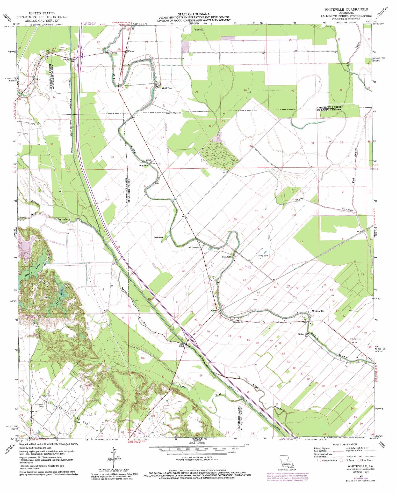
Whiteville Topo Map Louisiana
To zoom in, hover over the map of Whiteville
USGS Topo Quad 30092g2 - 1:24,000 scale
| Topo Map Name: | Whiteville |
| USGS Topo Quad ID: | 30092g2 |
| Print Size: | ca. 21 1/4" wide x 27" high |
| Southeast Coordinates: | 30.75° N latitude / 92.125° W longitude |
| Map Center Coordinates: | 30.8125° N latitude / 92.1875° W longitude |
| U.S. State: | LA |
| Filename: | o30092g2.jpg |
| Download Map JPG Image: | Whiteville topo map 1:24,000 scale |
| Map Type: | Topographic |
| Topo Series: | 7.5´ |
| Map Scale: | 1:24,000 |
| Source of Map Images: | United States Geological Survey (USGS) |
| Alternate Map Versions: |
Whiteville LA 1966, updated 1967 Download PDF Buy paper map Whiteville LA 1966, updated 1990 Download PDF Buy paper map Whiteville LA 1966, updated 1992 Download PDF Buy paper map Whiteville LA 2012 Download PDF Buy paper map Whiteville LA 2015 Download PDF Buy paper map |
1:24,000 Topo Quads surrounding Whiteville
Lecompte |
Cheneyville |
Belle D'Eau |
Marksville South |
Moreauville |
Cocodrie Lake |
Lone Pine |
Bunkie |
Cottonport |
Plaucheville |
Pine Prairie |
Saint Landry |
Whiteville |
Morrow |
Bayou Jack |
Mamou |
Ville Platte |
Tate Cove |
Beggs |
Palmetto |
Eunice North |
Chataignier |
Lawtell |
Opelousas |
Port Barre |
> Back to 30092e1 at 1:100,000 scale
> Back to 30092a1 at 1:250,000 scale
> Back to U.S. Topo Maps home
Whiteville topo map: Gazetteer
Whiteville: Airports
Whiteville Airport elevation 11m 36′Whiteville: Oilfields
Ville Platte Oil and Gas Field elevation 22m 72′Whiteville: Populated Places
Augusta elevation 14m 45′Barbreck elevation 13m 42′
Chappel (historical) elevation 11m 36′
Gold Dust elevation 15m 49′
Milburn elevation 15m 49′
Saint Louis elevation 13m 42′
Whiteville elevation 13m 42′
Whiteville: Post Offices
Barbreck Post Office (historical) elevation 14m 45′Whiteville Post Office elevation 13m 42′
Whiteville: Reservoirs
Indian Lake elevation 15m 49′Negro Lake elevation 11m 36′
Whiteville: Streams
Bayou Chicot elevation 8m 26′Coulee Teal elevation 5m 16′
Red Bayou elevation 12m 39′
Whiteville: Swamps
Cazan Lake elevation 11m 36′Whiteville digital topo map on disk
Buy this Whiteville topo map showing relief, roads, GPS coordinates and other geographical features, as a high-resolution digital map file on DVD: