Pine Prairie Topo Map Louisiana
To zoom in, hover over the map of Pine Prairie
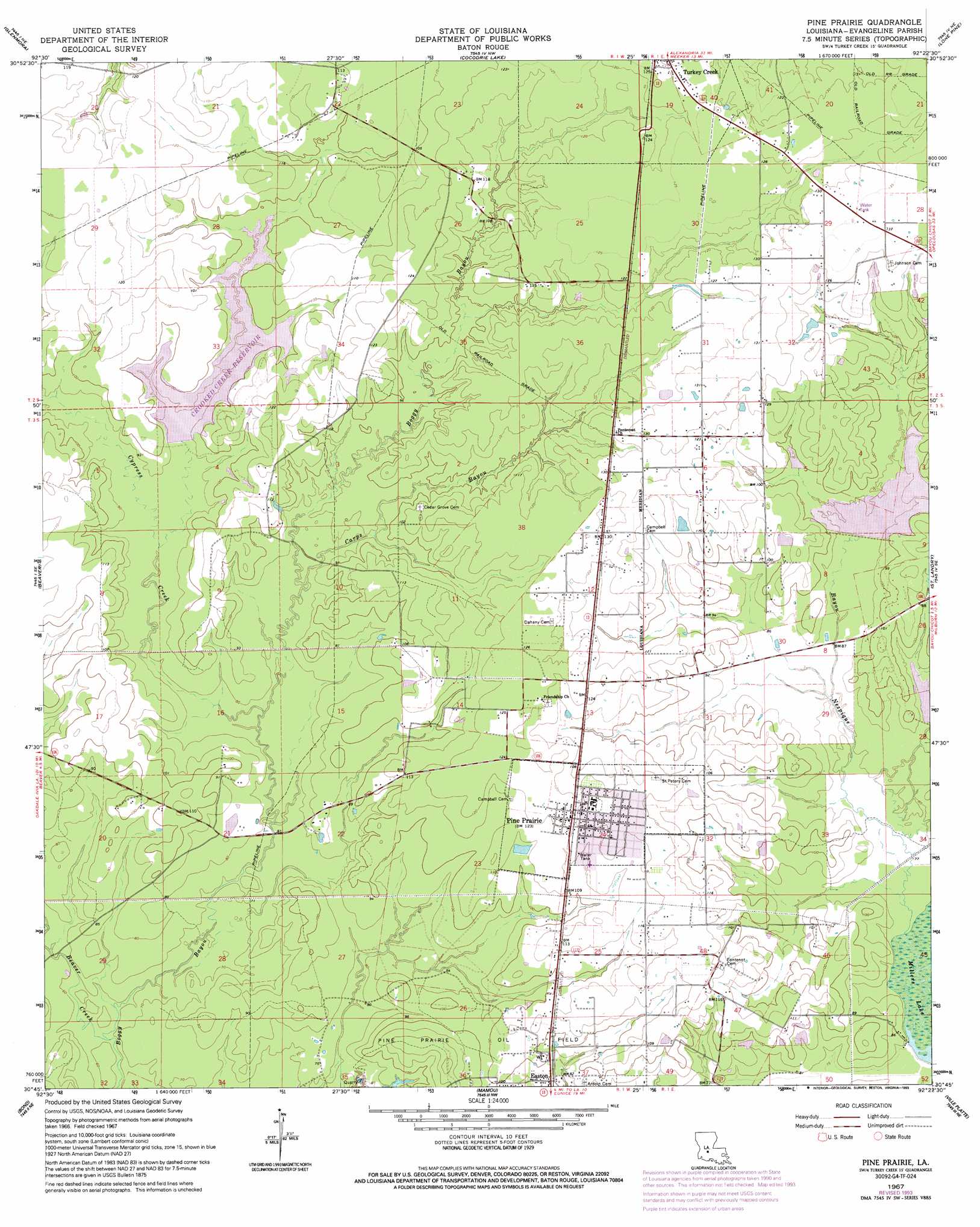
USGS Topo Quad 30092g4 - 1:24,000 scale
| Topo Map Name: | Pine Prairie |
| USGS Topo Quad ID: | 30092g4 |
| Print Size: | ca. 21 1/4" wide x 27" high |
| Southeast Coordinates: | 30.75° N latitude / 92.375° W longitude |
| Map Center Coordinates: | 30.8125° N latitude / 92.4375° W longitude |
| U.S. State: | LA |
| Filename: | o30092g4.jpg |
| Download Map JPG Image: | Pine Prairie topo map 1:24,000 scale |
| Map Type: | Topographic |
| Topo Series: | 7.5´ |
| Map Scale: | 1:24,000 |
| Source of Map Images: | United States Geological Survey (USGS) |
| Alternate Map Versions: |
Pine Prairie LA 1967, updated 1993 Download PDF Buy paper map Pine Prairie LA 2012 Download PDF Buy paper map Pine Prairie LA 2015 Download PDF Buy paper map |
1:24,000 Topo Quads surrounding Pine Prairie
Melder |
Forest Hill |
Lecompte |
Cheneyville |
Belle D'Eau |
Pawnee |
Glenmora |
Cocodrie Lake |
Lone Pine |
Bunkie |
Oakdale |
Beaver |
Pine Prairie |
Saint Landry |
Whiteville |
Guy |
Bond |
Mamou |
Ville Platte |
Tate Cove |
Soileau |
Duralde |
Eunice North |
Chataignier |
Lawtell |
> Back to 30092e1 at 1:100,000 scale
> Back to 30092a1 at 1:250,000 scale
> Back to U.S. Topo Maps home
Pine Prairie topo map: Gazetteer
Pine Prairie: Dams
Upper Bayou Nezpique Number Seven Dam elevation 25m 82′Upper Bayou Nezpique Number Six Dam elevation 27m 88′
Upper Bayou Nezpique Number Three Dam elevation 26m 85′
Pine Prairie: Populated Places
Beale elevation 37m 121′Easton elevation 27m 88′
Pine Prairie elevation 38m 124′
Pine Prairie: Reservoirs
Crooked Creek Reservoir elevation 26m 85′Pine Prairie: Streams
Bayou Nezpique elevation 23m 75′Beaver Creek elevation 20m 65′
Carps Bayou elevation 25m 82′
Cypress Creek elevation 23m 75′
Pine Prairie digital topo map on disk
Buy this Pine Prairie topo map showing relief, roads, GPS coordinates and other geographical features, as a high-resolution digital map file on DVD: