Orange Topo Map Louisiana
To zoom in, hover over the map of Orange
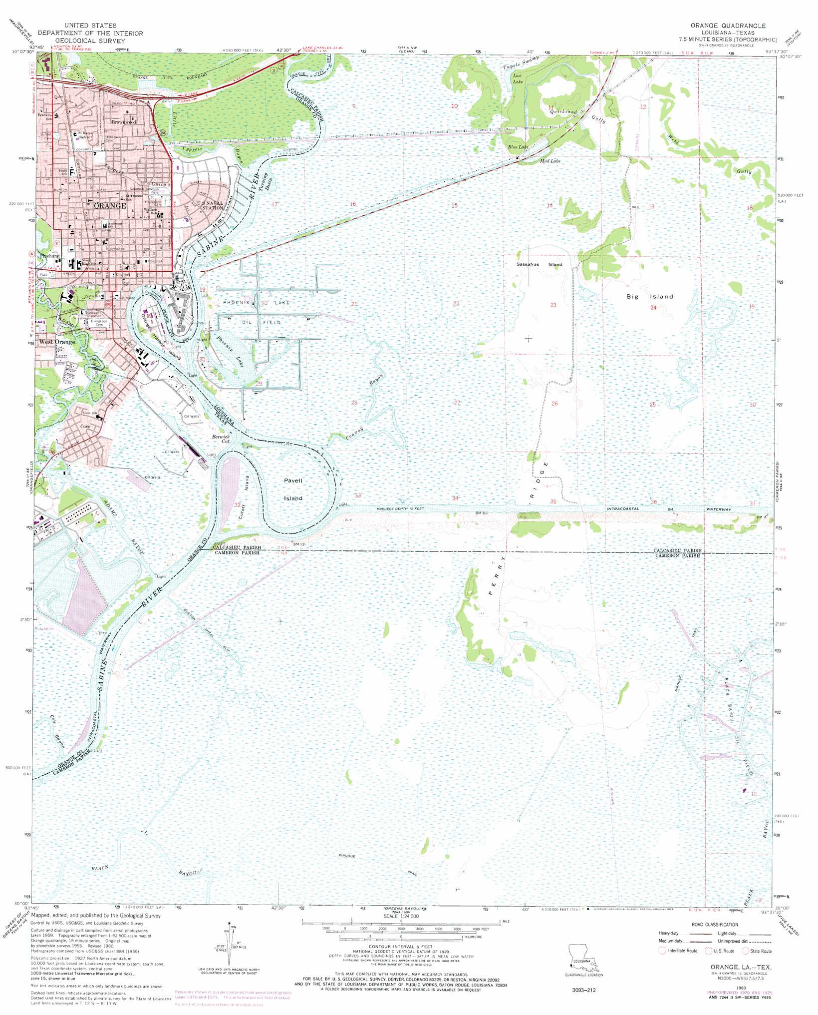
USGS Topo Quad 30093a6 - 1:24,000 scale
| Topo Map Name: | Orange |
| USGS Topo Quad ID: | 30093a6 |
| Print Size: | ca. 21 1/4" wide x 27" high |
| Southeast Coordinates: | 30° N latitude / 93.625° W longitude |
| Map Center Coordinates: | 30.0625° N latitude / 93.6875° W longitude |
| U.S. States: | LA, TX |
| Filename: | o30093a6.jpg |
| Download Map JPG Image: | Orange topo map 1:24,000 scale |
| Map Type: | Topographic |
| Topo Series: | 7.5´ |
| Map Scale: | 1:24,000 |
| Source of Map Images: | United States Geological Survey (USGS) |
| Alternate Map Versions: |
Orange TX 1926 Download PDF Buy paper map Orange TX 1960, updated 1961 Download PDF Buy paper map Orange TX 1960, updated 1970 Download PDF Buy paper map Orange TX 1960, updated 1971 Download PDF Buy paper map Orange TX 1960, updated 1976 Download PDF Buy paper map Orange TX 1960, updated 1978 Download PDF Buy paper map Orange TX 1996, updated 1999 Download PDF Buy paper map Orange TX 2010 Download PDF Buy paper map Orange TX 2013 Download PDF Buy paper map Orange TX 2016 Download PDF Buy paper map |
1:24,000 Topo Quads surrounding Orange
Gist |
Hartburg |
Starks |
Lunita |
Brimstone |
Texla |
Mauriceville |
Echo |
Vinton |
Sulphur |
Terry |
Orangefield |
Orange |
Cameron Farms |
Black Lake |
Port Arthur North |
West Of Greens Bayou |
Greens Bayou |
Five Lakes |
Browns Lake |
Port Arthur South |
West Of Johnsons Bayou |
Johnsons Bayou |
Peveto Beach |
Holly Beach |
> Back to 30093a1 at 1:100,000 scale
> Back to 30092a1 at 1:250,000 scale
> Back to U.S. Topo Maps home
Orange topo map: Gazetteer
Orange: Bends
Berwick Cut elevation 0m 0′Orange: Dams
Dupont Plant Reservoir Levee elevation 4m 13′Orange: Islands
Big Island elevation 1m 3′Cutoff Island elevation 0m 0′
Orange Harbor Island elevation 2m 6′
Pavell Island elevation 1m 3′
Sassafras Island elevation 1m 3′
Orange: Lakes
Blue Lake elevation 2m 6′Lost Lake elevation 2m 6′
Mud Lake elevation 0m 0′
Phoenix Lake elevation 0m 0′
Orange: Oilfields
Phoenix Lake Gas Field elevation 0m 0′Phoenix Lake Oil Field elevation 0m 0′
Orange: Parks
Lower Neches Wildlife Management Area - Adams Bayou elevation 1m 3′Navy Park elevation 2m 6′
Pinhurst City Park elevation 2m 6′
Solomon Johnson Park elevation 2m 6′
Sunset Park elevation 3m 9′
Orange: Populated Places
Brownwood elevation 3m 9′Cove elevation 3m 9′
Orange elevation 2m 6′
Orange: Reservoirs
Plant Reservoir elevation 4m 13′Orange: Ridges
Perry Ridge elevation 2m 6′Orange: Streams
Adams Bayou elevation 0m 0′Conway Bayou elevation 0m 0′
Cow Bayou elevation 0m 0′
Little Cypress Bayou elevation 0m 0′
Quicksand Gully elevation 1m 3′
Orange: Valleys
Coopers Gulley elevation 1m 3′Orange digital topo map on disk
Buy this Orange topo map showing relief, roads, GPS coordinates and other geographical features, as a high-resolution digital map file on DVD: