Bancroft Topo Map Louisiana
To zoom in, hover over the map of Bancroft
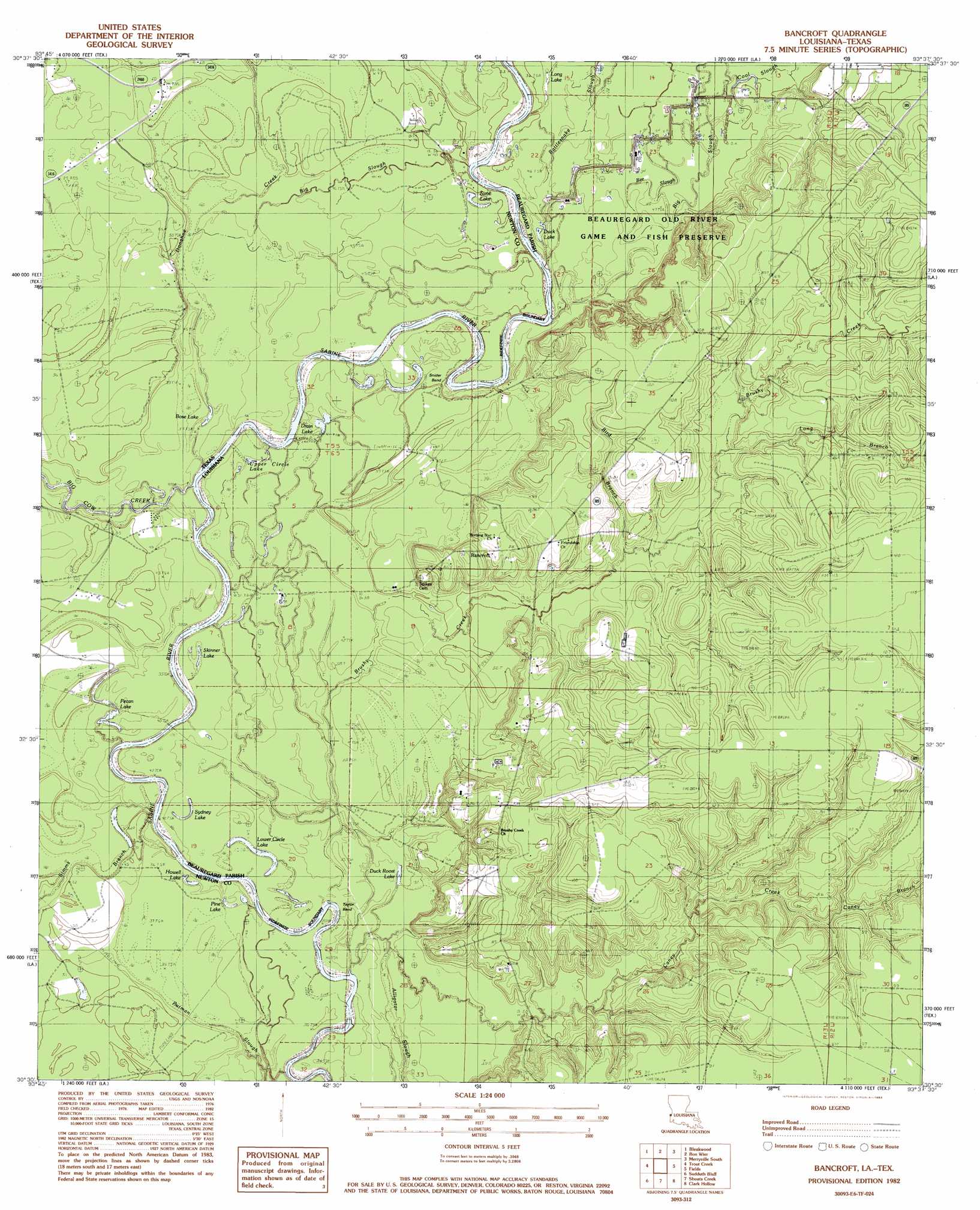
USGS Topo Quad 30093e6 - 1:24,000 scale
| Topo Map Name: | Bancroft |
| USGS Topo Quad ID: | 30093e6 |
| Print Size: | ca. 21 1/4" wide x 27" high |
| Southeast Coordinates: | 30.5° N latitude / 93.625° W longitude |
| Map Center Coordinates: | 30.5625° N latitude / 93.6875° W longitude |
| U.S. States: | LA, TX |
| Filename: | o30093e6.jpg |
| Download Map JPG Image: | Bancroft topo map 1:24,000 scale |
| Map Type: | Topographic |
| Topo Series: | 7.5´ |
| Map Scale: | 1:24,000 |
| Source of Map Images: | United States Geological Survey (USGS) |
| Alternate Map Versions: |
Bancroft LA 1982, updated 1983 Download PDF Buy paper map Bancroft LA 2010 Download PDF Buy paper map Bancroft LA 2012 Download PDF Buy paper map Bancroft LA 2015 Download PDF Buy paper map |
1:24,000 Topo Quads surrounding Bancroft
Roganville |
Newton West |
Newton East |
Merryville North |
Neale |
Kirbyville |
Bleakwood |
Bon Wier |
Merryville South |
Singer |
Call Junction |
Trout Creek |
Bancroft |
Fields |
Oretta |
Buna |
Sudduth Bluff |
Shoats Creek |
Clark Hollow |
De Quincy |
Gist |
Hartburg |
Starks |
Lunita |
Brimstone |
> Back to 30093e1 at 1:100,000 scale
> Back to 30092a1 at 1:250,000 scale
> Back to U.S. Topo Maps home
Bancroft topo map: Gazetteer
Bancroft: Bends
Snider Bend elevation 13m 42′Taylor Bend elevation 12m 39′
Taylor Bend elevation 11m 36′
Bancroft: Crossings
Salem Ferry (historical) elevation 12m 39′Whitmans Ferry (historical) elevation 14m 45′
Bancroft: Guts
Bee Slough elevation 14m 45′Big Slough elevation 14m 45′
Bancroft: Lakes
Bose Lake elevation 13m 42′Drain Lake elevation 13m 42′
Duck Lake elevation 14m 45′
Howell Lake elevation 12m 39′
Long Lake elevation 15m 49′
Lower Circle Lake elevation 11m 36′
Pecan Lake elevation 12m 39′
Pine Lake elevation 11m 36′
Sime Lake elevation 14m 45′
Skinner Lake elevation 12m 39′
Sydney Lake elevation 12m 39′
Upper Circle Lake elevation 14m 45′
Bancroft: Oilfields
Bancroft Oil Field elevation 25m 82′North Bancroft Oil Field elevation 15m 49′
Skinner Lakes Oil Field elevation 12m 39′
Bancroft: Populated Places
Bancroft elevation 26m 85′Bancroft: Streams
Big Cow Creek elevation 12m 39′Big Slough elevation 14m 45′
Bird Branch elevation 17m 55′
Brushy Creek elevation 11m 36′
Bugger Branch elevation 14m 45′
Caney Branch elevation 21m 68′
Caney Creek elevation 11m 36′
Cool Slough elevation 14m 45′
Donahoe Creek elevation 13m 42′
Long Branch elevation 20m 65′
Rattlesnake Slough elevation 14m 45′
Simms Branch elevation 12m 39′
Bancroft: Swamps
Duck Roost Lake elevation 11m 36′Bancroft digital topo map on disk
Buy this Bancroft topo map showing relief, roads, GPS coordinates and other geographical features, as a high-resolution digital map file on DVD: