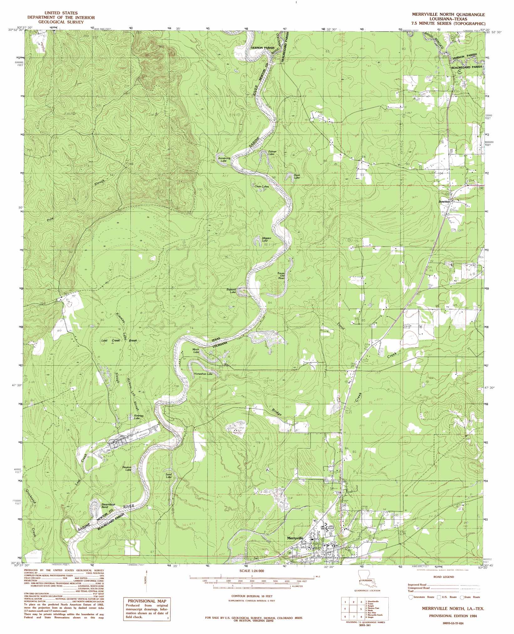
Merryville North Topo Map Louisiana
To zoom in, hover over the map of Merryville North
USGS Topo Quad 30093g5 - 1:24,000 scale
| Topo Map Name: | Merryville North |
| USGS Topo Quad ID: | 30093g5 |
| Print Size: | ca. 21 1/4" wide x 27" high |
| Southeast Coordinates: | 30.75° N latitude / 93.5° W longitude |
| Map Center Coordinates: | 30.8125° N latitude / 93.5625° W longitude |
| U.S. States: | LA, TX |
| Filename: | o30093g5.jpg |
| Download Map JPG Image: | Merryville North topo map 1:24,000 scale |
| Map Type: | Topographic |
| Topo Series: | 7.5´ |
| Map Scale: | 1:24,000 |
| Source of Map Images: | United States Geological Survey (USGS) |
| Alternate Map Versions: |
Merryville North LA 1984, updated 1985 Download PDF Buy paper map Merryville North LA 2010 Download PDF Buy paper map Merryville North LA 2012 Download PDF Buy paper map Merryville North LA 2015 Download PDF Buy paper map |
1:24,000 Topo Quads surrounding Merryville North
Weeks Settlement |
Wiergate |
Wiergate Se |
Burr Ferry |
Newllano |
Jamestown |
Shankleville |
Evans |
Knight |
Rose Pine |
Newton West |
Newton East |
Merryville North |
Neale |
De Ridder |
Bleakwood |
Bon Wier |
Merryville South |
Singer |
Mach Branch |
Trout Creek |
Bancroft |
Fields |
Oretta |
Kernan |
> Back to 30093e1 at 1:100,000 scale
> Back to 30092a1 at 1:250,000 scale
> Back to U.S. Topo Maps home
Merryville North topo map: Gazetteer
Merryville North: Bends
Steamboat Bend elevation 17m 55′Merryville North: Crossings
Clines Ferry (historical) elevation 18m 59′Merryville North: Lakes
Alligator Lake elevation 20m 65′Armstrong Lake elevation 23m 75′
Black Lake elevation 18m 59′
Chain Lakes elevation 22m 72′
Eaves Old River elevation 19m 62′
Horseshoe Lake elevation 19m 62′
Kimmey Lake elevation 21m 68′
Moon Lake elevation 21m 68′
Palmer Lake elevation 20m 65′
Ryan Lake elevation 20m 65′
Sand Lake elevation 19m 62′
Merryville North: Oilfields
Bayou Anacoco Gas Field elevation 29m 95′Merryville Oil Field elevation 22m 72′
Merryville North: Populated Places
Junction elevation 29m 95′Merryville elevation 24m 78′
Merryville North: Post Offices
Merryville Post Office elevation 24m 78′Merryville North: Streams
Bayou Anacoco elevation 20m 65′Bridge Creek elevation 19m 62′
Lost Creek elevation 19m 62′
Pole Slough elevation 22m 72′
Trout Creek elevation 21m 68′
Merryville North: Swamps
Kimmey Lake Slough elevation 21m 68′Merryville North digital topo map on disk
Buy this Merryville North topo map showing relief, roads, GPS coordinates and other geographical features, as a high-resolution digital map file on DVD: