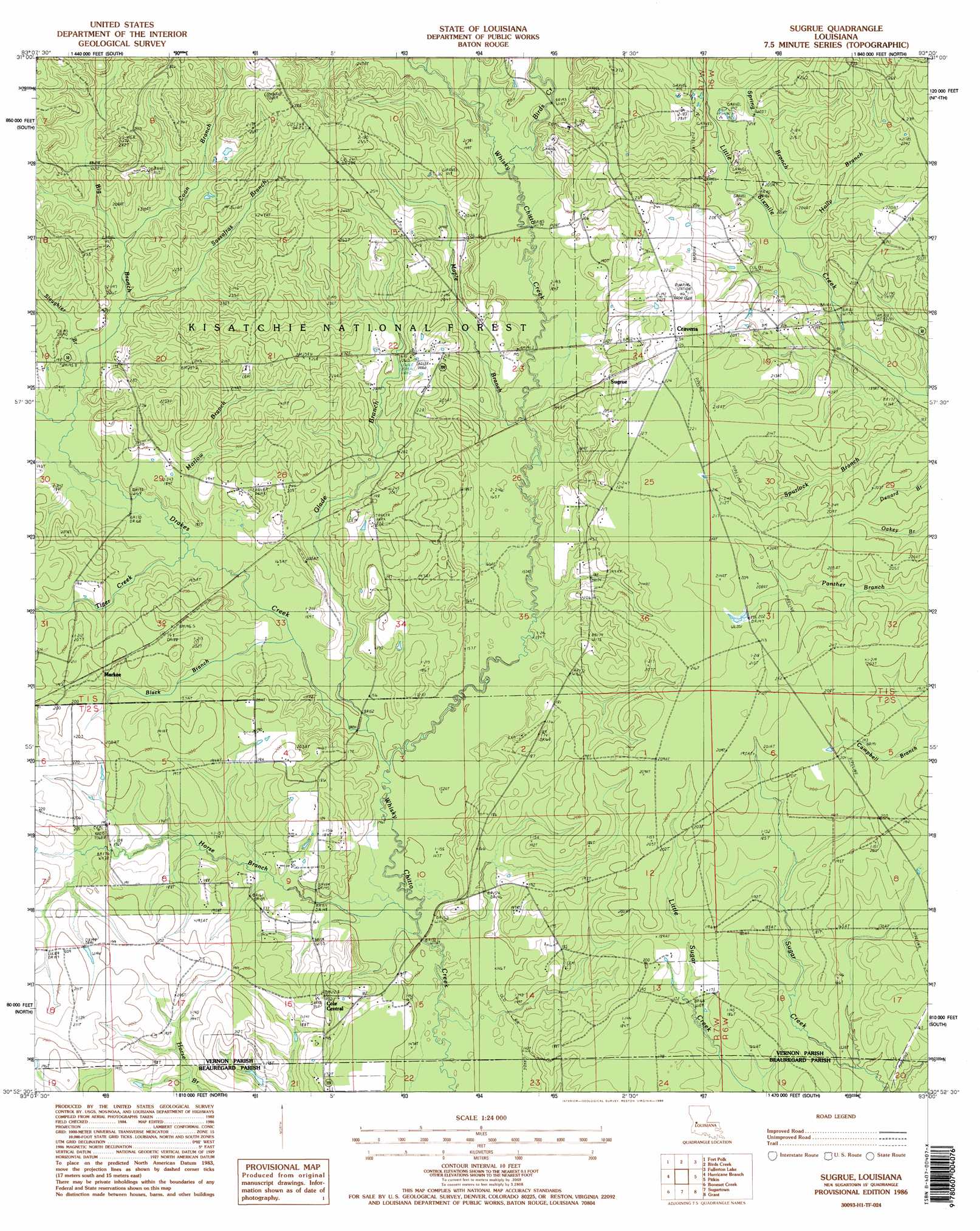
Sugrue Topo Map Louisiana
To zoom in, hover over the map of Sugrue
USGS Topo Quad 30093h1 - 1:24,000 scale
| Topo Map Name: | Sugrue |
| USGS Topo Quad ID: | 30093h1 |
| Print Size: | ca. 21 1/4" wide x 27" high |
| Southeast Coordinates: | 30.875° N latitude / 93° W longitude |
| Map Center Coordinates: | 30.9375° N latitude / 93.0625° W longitude |
| U.S. State: | LA |
| Filename: | o30093h1.jpg |
| Download Map JPG Image: | Sugrue topo map 1:24,000 scale |
| Map Type: | Topographic |
| Topo Series: | 7.5´ |
| Map Scale: | 1:24,000 |
| Source of Map Images: | United States Geological Survey (USGS) |
| Alternate Map Versions: |
Sugrue LA 1986, updated 1986 Download PDF Buy paper map Sugrue LA 1986, updated 1986 Download PDF Buy paper map Sugrue LA 2004, updated 2005 Download PDF Buy paper map Sugrue LA 2012 Download PDF Buy paper map Sugrue LA 2015 Download PDF Buy paper map |
| FStopo: | US Forest Service topo Sugrue is available: Download FStopo PDF Download FStopo TIF |
1:24,000 Topo Quads surrounding Sugrue
Leesville |
Slagle |
Simpson South |
Lacamp |
Sieper |
Newllano |
Fort Polk |
Birds Creek |
Fullerton Lake |
Afeman |
Rose Pine |
Hurricane Branch |
Sugrue |
Pitkin |
Steep Gully |
De Ridder |
Boneset Creek |
Sugartown |
Grant |
Elizabeth |
Mach Branch |
Redhead Branch |
Dry Creek |
Mittie |
Pine Chapel |
> Back to 30093e1 at 1:100,000 scale
> Back to 30092a1 at 1:250,000 scale
> Back to U.S. Topo Maps home
Sugrue topo map: Gazetteer
Sugrue: Dams
Louisiana Noname 62 Dam elevation 63m 206′Sugrue: Populated Places
Cole Central elevation 56m 183′Cravens elevation 71m 232′
Markee elevation 63m 206′
Sugrue elevation 65m 213′
Sugrue: Streams
Big Branch elevation 52m 170′Birds Creek elevation 56m 183′
Black Branch elevation 47m 154′
Coon Branch elevation 60m 196′
Cowpen Branch elevation 62m 203′
Drakes Creek elevation 46m 150′
Glade Branch elevation 46m 150′
Holly Branch elevation 55m 180′
Horse Branch elevation 43m 141′
Maple Branch elevation 53m 173′
Marlow Branch elevation 50m 164′
Sassafras Branch elevation 57m 187′
Slaughter Branch elevation 54m 177′
Spring Branch elevation 55m 180′
Spurlock Branch elevation 51m 167′
Tiger Creek elevation 50m 164′
Sugrue: Trails
Big Branch Trail elevation 70m 229′Sugrue digital topo map on disk
Buy this Sugrue topo map showing relief, roads, GPS coordinates and other geographical features, as a high-resolution digital map file on DVD: